![](/images/other/stat-length.png)
![Trail Cycle Le Rozier - Circuit des 10 plus beaux villages de France de l'Aveyron - Le Rozier - Nant - Photo](https://media.geolcdn.com/t/1900/400/ext.pjpeg?maxdim=2&url=https%3A%2F%2Fservices.sitytrail.com%2FGeolivesWS%2FDownloadMedia.ashx%3FTrailID%3D172361%26Media%3D13701_5.jpg)
Circuit des 10 plus beaux villages de France de l'Aveyron - Le Rozier - Nant
tracegps
User
![Length](/images/other/stat-length.png)
![Max alt](https://static1.geolcdn.com/siteimages/upload/files/1508320355ic_sort_altitude_max_24dp.png)
![Uphill gradient](https://static1.geolcdn.com/siteimages/upload/files/1508320355ic_sort_den_pos_24dp.png)
![Km-Effort](/images/other/stat-length.png)
![Min alt](https://static1.geolcdn.com/siteimages/upload/files/1508320355ic_sort_altitude_min_24dp.png)
![Downhill gradient](https://static1.geolcdn.com/siteimages/upload/files/1508320355ic_sort_den_neg_24dp.png)
![Boucle](https://static1.geolcdn.com/siteimages/upload/files/16400158638029165_repeat_loop_refresh_sync_direction_icon.png)
![Cycle](https://static1.geolcdn.com/sitytour/trail-icons/200.png)
6h00
Difficulty : Difficult
![Scan this QR Code to open this trail in the SityTrail application](https://capi.geolives.com/qq0zvz2zws4bq2lad0pu/sitytour/trails/172361/qr.png?size=200)
FREE GPS app for hiking
About
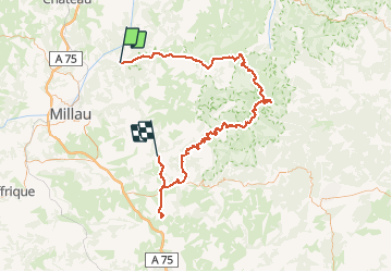
Trail Cycle of 122 km to be discovered at Occitania, Lozère, Le Rozier. This trail is proposed by tracegps.
Description
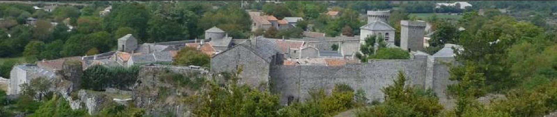
Circuit proposé par le Comité Départemental de Tourisme de l'Aveyron. Au départ de Le Rozier, vous quittez les Gorges du Tarn pour pénétrer dans les Gorges de la Jonte. Survolé par les vautours fauves, un magnifique spectacle s'offre à vous. Lors de ce long parcours des points de vues impressionnants se découvrent à l'exemple du Mont Aigoual (vue sur la mer par beau temps!). En fin de journée, vous laisserez monts et gorges derrière vous pour rouler facilement sur le plateau du Larzac. Un court aller-retour s'impose pour visiter le village classé de la Couvertoirade, cité Templière.
Positioning
Comments
Trails nearby
![Trail Walking Le Rozier - 12 vase de Sèvres Chine ch. brunet - Photo](https://media.geolcdn.com/t/375/260/42bd83b0-7fd2-4ea6-86ca-ddc89ff015aa.jpg&format=jpg&maxdim=2)
![Walking Walking](https://static1.geolcdn.com/sitytour/trail-icons/101.png)
Walking
![](/images/other/stat-length.png)
![](https://static1.geolcdn.com/siteimages/upload/files/16400158638029165_repeat_loop_refresh_sync_direction_icon.png)
![Trail Walking Mostuéjouls - Cirque de Saint Marcellin - Mostuéjouls - Liaucous - Photo](https://media.geolcdn.com/t/375/260/ext.jpg?maxdim=2&url=https%3A%2F%2Fservices.sitytrail.com%2FGeolivesWS%2FDownloadMedia.ashx%3FTrailID%3D173134%26Media%3D14690_6.jpg)
![Walking Walking](https://static1.geolcdn.com/sitytour/trail-icons/101.png)
Walking
![](/images/other/stat-length.png)
![](https://static1.geolcdn.com/siteimages/upload/files/16400158638029165_repeat_loop_refresh_sync_direction_icon.png)
![Trail Walking Le Rozier - Causse et gorges au pays des vautours - Photo](https://media.geolcdn.com/t/375/260/cab4842f-73f8-42f5-b236-9c9a4da22964.jpg&format=jpg&maxdim=2)
![Walking Walking](https://static1.geolcdn.com/sitytour/trail-icons/101.png)
Walking
![](/images/other/stat-length.png)
![](https://static1.geolcdn.com/siteimages/upload/files/16400158638029165_repeat_loop_refresh_sync_direction_icon.png)
![Trail Walking Saint-Pierre-des-Tripiers - Cassagnes crête vallée Jonte et Tarn 12,2 km - Photo](https://media.geolcdn.com/t/375/260/9473c7ff-c94b-41a9-84a9-d12f53c1c0cb.jpg&format=jpg&maxdim=2)
![Walking Walking](https://static1.geolcdn.com/sitytour/trail-icons/101.png)
Walking
![](/images/other/stat-length.png)
![](https://static1.geolcdn.com/siteimages/upload/files/16400158638029165_repeat_loop_refresh_sync_direction_icon.png)
![Trail Walking Rivière-sur-Tarn - Grands Causses - Peyrelade - Chateau-vignes-forêt - 2016 09 09 - Photo](https://media.geolcdn.com/t/375/260/ext.jpg?maxdim=2&url=https%3A%2F%2Fservices.sitytrail.com%2FGeolivesWS%2FDownloadMedia.ashx%3FTrailID%3D629408%26Media%3Dfix__20160909102534.jpg)
![Walking Walking](https://static1.geolcdn.com/sitytour/trail-icons/101.png)
Walking
![](/images/other/stat-length.png)
![](https://static1.geolcdn.com/siteimages/upload/files/16400158638029165_repeat_loop_refresh_sync_direction_icon.png)
![Trail Walking Saint-Pierre-des-Tripiers - Grands Causses - Cassagnes - Corniches du Causse Méjean - 2016 09 08 - Photo](https://media.geolcdn.com/t/375/260/ext.jpg?maxdim=2&url=https%3A%2F%2Fservices.sitytrail.com%2FGeolivesWS%2FDownloadMedia.ashx%3FTrailID%3D629401%26Media%3Dfix__20160908104835.jpg)
![Walking Walking](https://static1.geolcdn.com/sitytour/trail-icons/101.png)
Walking
![](/images/other/stat-length.png)
![](https://static1.geolcdn.com/siteimages/upload/files/16400158638029165_repeat_loop_refresh_sync_direction_icon.png)
![Trail Walking Peyreleau - Grands Causses - Peyreleau - Corniches du Causse Noir- 2016 09 06 - Photo](https://media.geolcdn.com/t/375/260/ext.jpg?maxdim=2&url=https%3A%2F%2Fservices.sitytrail.com%2FGeolivesWS%2FDownloadMedia.ashx%3FTrailID%3D629392%26Media%3Dfix__20160906104401.jpg)
![Walking Walking](https://static1.geolcdn.com/sitytour/trail-icons/101.png)
Walking
![](/images/other/stat-length.png)
![](https://static1.geolcdn.com/siteimages/upload/files/16400158638029165_repeat_loop_refresh_sync_direction_icon.png)
![Trail Walking Mostuéjouls - Grands Causses - Liaucous - St-Marcellin - 2016 07 04 - 680m 14,3km - Photo](https://media.geolcdn.com/t/375/260/ext.jpg?maxdim=2&url=https%3A%2F%2Fservices.sitytrail.com%2FGeolivesWS%2FDownloadMedia.ashx%3FTrailID%3D595296%26Media%3Dfix__20160704145129.jpg)
![Walking Walking](https://static1.geolcdn.com/sitytour/trail-icons/101.png)
Walking
![](/images/other/stat-length.png)
![](https://static1.geolcdn.com/siteimages/upload/files/16400158638029165_repeat_loop_refresh_sync_direction_icon.png)
![Trail Walking Veyreau - J3 St Jean des Balmes Ermitage St Michel - Photo](https://media.geolcdn.com/t/375/260/ext.jpg?maxdim=2&url=https%3A%2F%2Fstatic1.geolcdn.com%2Fsiteimages%2Fupload%2Ffiles%2F1553511878bg_sport_marche.png)
![Walking Walking](https://static1.geolcdn.com/sitytour/trail-icons/101.png)
Walking
![](/images/other/stat-length.png)
![](https://static1.geolcdn.com/siteimages/upload/files/16400158638029165_repeat_loop_refresh_sync_direction_icon.png)