Trail Walking Béthonsart - Bethonsart Caucourt Mingoval - Photo

Bethonsart Caucourt Mingoval

 tracegps
tracegps

User

© OpenStreetMap contributors
Length
Length
11.7 km
Max alt
Max alt
156 m
Uphill gradient
Uphill gradient
105 m
Km-Effort
Km-Effort  
13.2 km
Min alt
Min alt
94 m
Downhill gradient
Downhill gradient
109 m
Boucle
Boucle
Yes
Creation date :
2014-12-10 00:00:00.0
Updated on :
2014-12-10 00:00:00.0

(0 Reviews)

Walking
Walking
2h30
Difficulty : Medium

Scan this QR Code to open this trail in the SityTrail application

FREE GPS app for hiking

Logo SityTrail SityTrail

IGN / Geographical institutes

Download SityTrail from the App Store Download SityTrail from Google Play

Logo SityTrail SityTrail World

The world is yours!

Download SityTrail from the App Store Download SityTrail from Google Play Download SityTrail on Huawei AppGallery

About

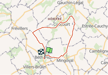
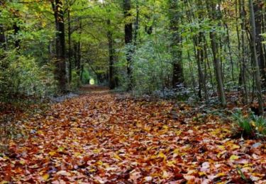
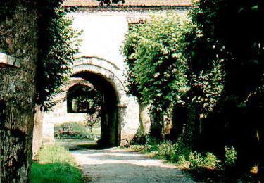
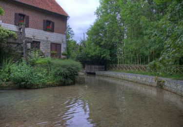
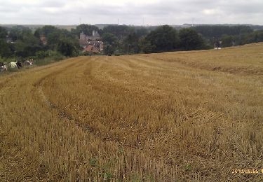
Trail Walking of 11.7 km to be discovered at Hauts-de-France, Pas-de-Calais, Béthonsart. This trail is proposed by tracegps.

Description

Beau parcours qui emprunte des chemins creux sur Caucourt (à faire par beau temps) et le gué de Caucourt.

Elevation profile

Photos

Positioning

Country:
France
Region :
Hauts-de-France
Department/Province :
Pas-de-Calais
Municipality :
Béthonsart
Location:
Unknown
Start:(UTM)
468135 ; 5580502 (31U) N.

Trails nearby

Trail Walking Magnicourt-en-Comte - Chemin de la vallée des prêtres (Magnicourt-en-Comte) - Photo
Walking
tracegps

Walking

Easy
Magnicourt-en-Comte, Hauts-de-France, Pas-de-Calais, France
4.6 km | 5.6 km-effort
1h 15min
Yes
Trail Walking Villers-Châtel - Chemin de la charbonnière (Villers-Châtel)  - Photo
Walking
tracegps

Walking

Medium
Villers-Châtel, Hauts-de-France, Pas-de-Calais, France
11.8 km | 13.4 km-effort
3h 0min
Yes
Trail Walking Gauchin-Légal - Vieux cailloux et patois - Photo
Walking
tracegps

Walking

Difficult
(2)
Gauchin-Légal, Hauts-de-France, Pas-de-Calais, France
26 km | 31 km-effort
5h 30min
Yes
Trail Walking Cambligneul - Cambigneul - Villers Chatel - Mingoval - Caucourt - Estée Cauchy - Photo
Walking
tracegps

Walking

Medium
Cambligneul, Hauts-de-France, Pas-de-Calais, France
9.9 km | 11.1 km-effort
2h 0min
Yes
Trail Walking Gauchin-Légal - Autour du golf d'Olhain - Gauchin Légal - Photo
Walking
tracegps

Walking

Medium
Gauchin-Légal, Hauts-de-France, Pas-de-Calais, France
8.1 km | 10.2 km-effort
2h 0min
Yes
Trail Walking Chelers - Chemin des Bosquets (Chelers) - Photo
Walking
tracegps

Walking

Difficult
Chelers, Hauts-de-France, Pas-de-Calais, France
14.7 km | 16.5 km-effort
3h 45min
Yes
Trail Walking Gauchin-Légal - En passant par le gué de Caucourt - Photo
Walking
tracegps

Walking

Medium
(2)
Gauchin-Légal, Hauts-de-France, Pas-de-Calais, France
9.1 km | 10.3 km-effort
2h 0min
Yes
Trail Walking Gauchin-Légal - Gauchin le Gal - Tour du golf d'Olhain - Photo
Walking
tracegps

Walking

Medium
Gauchin-Légal, Hauts-de-France, Pas-de-Calais, France
8 km | 10 km-effort
1h 40min
Yes
Trail Mountain bike Tincques - Rando_Tincques2012 - Photo
Mountain bike
tantan62

Mountain bike

Medium
Tincques, Hauts-de-France, Pas-de-Calais, France
71 km | 81 km-effort
Unknown
Yes


Close
My subscriptions