![](/images/other/stat-length.png)
![Trail Walking Lapte - Petite virée au Bourg des 32 clochers - Lapte - Photo](https://media.geolcdn.com/t/1900/400/ext.pjpeg?maxdim=2&url=https%3A%2F%2Fservices.sitytrail.com%2FGeolivesWS%2FDownloadMedia.ashx%3FTrailID%3D172314%26Media%3D13635_4.jpg)
Petite virée au Bourg des 32 clochers - Lapte
tracegps
User
![Length](/images/other/stat-length.png)
Length
7.8 km
![Max alt](https://static1.geolcdn.com/siteimages/upload/files/1508320355ic_sort_altitude_max_24dp.png)
Max alt
875 m
![Uphill gradient](https://static1.geolcdn.com/siteimages/upload/files/1508320355ic_sort_den_pos_24dp.png)
Uphill gradient
246 m
![Km-Effort](/images/other/stat-length.png)
Km-Effort
11.1 km
![Min alt](https://static1.geolcdn.com/siteimages/upload/files/1508320355ic_sort_altitude_min_24dp.png)
Min alt
730 m
![Downhill gradient](https://static1.geolcdn.com/siteimages/upload/files/1508320355ic_sort_den_neg_24dp.png)
Downhill gradient
247 m
![Boucle](https://static1.geolcdn.com/siteimages/upload/files/16400158638029165_repeat_loop_refresh_sync_direction_icon.png)
Boucle
Yes
Creation date :
2014-12-10 00:00:00.0
Updated on :
2014-12-10 00:00:00.0
![Walking](https://static1.geolcdn.com/sitytour/trail-icons/101.png)
2h00
Difficulty : Medium
![Scan this QR Code to open this trail in the SityTrail application](https://capi.geolives.com/qq0zvz2zws4bq2lad0pu/sitytour/trails/172314/qr.png?size=200)
FREE GPS app for hiking
About
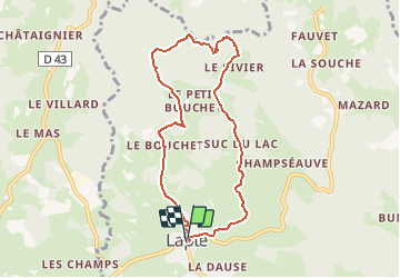
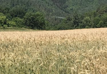
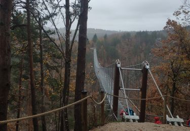
Trail Walking of 7.8 km to be discovered at Auvergne-Rhône-Alpes, Haute-Loire, Lapte. This trail is proposed by tracegps.
Description
Petite balade dans les environs de Lapte, le bourg dont le clocher permet d'apercevoir- par temps clair - 32 clochers. Ancien oppidum romain qui offre des sentiers sauvages et vallonnés. Visite de son église possible.
Positioning
Country:
France
Region :
Auvergne-Rhône-Alpes
Department/Province :
Haute-Loire
Municipality :
Lapte
Location:
Unknown
Start:(Dec)
Start:(UTM)
595605 ; 5004205 (31T) N.
Comments
Trails nearby
![Trail Mountain bike Lapte - Espace VTT FFC Le Velay des 3 Rivières - N°19 Lavalette Lapte Chenereilles - Photo](https://media.geolcdn.com/t/375/260/ext.jpg?maxdim=2&url=https%3A%2F%2Fservices.sitytrail.com%2FGeolivesWS%2FDownloadMedia.ashx%3FTrailID%3D101820%26Media%3D2095_1.jpg)
![Mountain bike Mountain bike](https://static1.geolcdn.com/sitytour/trail-icons/202.png)
Espace VTT FFC Le Velay des 3 Rivières - N°19 Lavalette Lapte Chenereilles
Mountain bike
Medium
(1)
Lapte,
Auvergne-Rhône-Alpes,
Haute-Loire,
France
![](/images/other/stat-length.png)
28 km | 36 km-effort
3h 15min
![](https://static1.geolcdn.com/siteimages/upload/files/16400158638029165_repeat_loop_refresh_sync_direction_icon.png)
Yes
![Trail Walking Saint-Pal-de-Mons - chapelle ste julien-7 km - Photo](https://media.geolcdn.com/t/375/260/cfa5e2e6-8689-4e6b-80b6-6f81820462e4.jpg&format=jpg&maxdim=2)
![Walking Walking](https://static1.geolcdn.com/sitytour/trail-icons/101.png)
chapelle ste julien-7 km
Walking
Medium
Saint-Pal-de-Mons,
Auvergne-Rhône-Alpes,
Haute-Loire,
France
![](/images/other/stat-length.png)
7.1 km | 10.5 km-effort
2h 13min
![](https://static1.geolcdn.com/siteimages/upload/files/16400158638029165_repeat_loop_refresh_sync_direction_icon.png)
Yes
![Trail Walking Sainte-Sigolène - ste sigolene - boucle de vaubarlet - Photo](https://media.geolcdn.com/t/375/260/be2999b1-8a7c-4639-9ccb-00bd9d8be97a.jpg&format=jpg&maxdim=2)
![Walking Walking](https://static1.geolcdn.com/sitytour/trail-icons/101.png)
ste sigolene - boucle de vaubarlet
Walking
Difficult
Sainte-Sigolène,
Auvergne-Rhône-Alpes,
Haute-Loire,
France
![](/images/other/stat-length.png)
7.8 km | 12 km-effort
2h 44min
![](https://static1.geolcdn.com/siteimages/upload/files/16400158638029165_repeat_loop_refresh_sync_direction_icon.png)
Yes
![Trail Walking Grazac - Passerelles du Lignon - Photo](https://media.geolcdn.com/t/375/260/30a20dec-ccba-4a3b-9421-f7a322f01f87.jpg&format=jpg&maxdim=2)
![Walking Walking](https://static1.geolcdn.com/sitytour/trail-icons/101.png)
Passerelles du Lignon
Walking
Medium
Grazac,
Auvergne-Rhône-Alpes,
Haute-Loire,
France
![](/images/other/stat-length.png)
6 km | 9.2 km-effort
1h 36min
![](https://static1.geolcdn.com/siteimages/upload/files/16400158638029165_repeat_loop_refresh_sync_direction_icon.png)
Yes
![Trail Walking Grazac - Gorges du Lignon - Photo](https://media.geolcdn.com/t/375/260/c288bea0-5a87-4e7b-81c9-465f5a7fd2b7.jpg&format=jpg&maxdim=2)
![Walking Walking](https://static1.geolcdn.com/sitytour/trail-icons/101.png)
Gorges du Lignon
Walking
Easy
Grazac,
Auvergne-Rhône-Alpes,
Haute-Loire,
France
![](/images/other/stat-length.png)
10.6 km | 14.3 km-effort
4h 10min
![](https://static1.geolcdn.com/siteimages/upload/files/16400158638029165_repeat_loop_refresh_sync_direction_icon.png)
Yes
![Trail Walking Grazac - De Charrerogne en Dunière - Vaubarlet - Photo](https://media.geolcdn.com/t/375/260/ext.jpg?maxdim=2&url=https%3A%2F%2Fservices.sitytrail.com%2FGeolivesWS%2FDownloadMedia.ashx%3FTrailID%3D172884%26Media%3D14342_5.jpg)
![Walking Walking](https://static1.geolcdn.com/sitytour/trail-icons/101.png)
De Charrerogne en Dunière - Vaubarlet
Walking
Difficult
Grazac,
Auvergne-Rhône-Alpes,
Haute-Loire,
France
![](/images/other/stat-length.png)
7.1 km | 10.3 km-effort
2h 30min
![](https://static1.geolcdn.com/siteimages/upload/files/16400158638029165_repeat_loop_refresh_sync_direction_icon.png)
Yes
![Trail Walking Grazac - Grazac la passerelle - Photo](https://media.geolcdn.com/t/375/260/f2e9779a-57c2-4245-b0ad-3c869e079b0b.jpg&format=jpg&maxdim=2)
![Walking Walking](https://static1.geolcdn.com/sitytour/trail-icons/101.png)
Grazac la passerelle
Walking
Easy
Grazac,
Auvergne-Rhône-Alpes,
Haute-Loire,
France
![](/images/other/stat-length.png)
6.8 km | 10.2 km-effort
2h 11min
![](https://static1.geolcdn.com/siteimages/upload/files/16400158638029165_repeat_loop_refresh_sync_direction_icon.png)
Yes
![Trail Walking Grazac - 25 novembre 2022 grazac - Photo](https://media.geolcdn.com/t/375/260/bef94bef-ac2e-42e0-bef5-579094f95342.jpg&format=jpg&maxdim=2)
![Walking Walking](https://static1.geolcdn.com/sitytour/trail-icons/101.png)
25 novembre 2022 grazac
Walking
Very difficult
Grazac,
Auvergne-Rhône-Alpes,
Haute-Loire,
France
![](/images/other/stat-length.png)
19.6 km | 27 km-effort
6h 12min
![](https://static1.geolcdn.com/siteimages/upload/files/16400158638029165_repeat_loop_refresh_sync_direction_icon.png)
Yes
![Trail Walking Grazac - grazac - Photo](https://media.geolcdn.com/t/375/260/3c3d3b97-5437-4b15-a984-200e7e385c51.jpg&format=jpg&maxdim=2)
![Walking Walking](https://static1.geolcdn.com/sitytour/trail-icons/101.png)
grazac
Walking
Medium
(1)
Grazac,
Auvergne-Rhône-Alpes,
Haute-Loire,
France
![](/images/other/stat-length.png)
6.4 km | 9.7 km-effort
2h 37min
![](https://static1.geolcdn.com/siteimages/upload/files/16400158638029165_repeat_loop_refresh_sync_direction_icon.png)
Yes