![](/images/other/stat-length.png)
![Trail Mountain bike Salt-en-Donzy - VTT - Salt en Donzy (2012) - Photo](https://media.geolcdn.com/t/1900/400/ext.pjpeg?maxdim=2&url=https%3A%2F%2Fservices.sitytrail.com%2FGeolivesWS%2FDownloadMedia.ashx%3FTrailID%3D172269%26Media%3D13582_6.jpg)
VTT - Salt en Donzy (2012)
tracegps
User
![Length](/images/other/stat-length.png)
![Max alt](https://static1.geolcdn.com/siteimages/upload/files/1508320355ic_sort_altitude_max_24dp.png)
![Uphill gradient](https://static1.geolcdn.com/siteimages/upload/files/1508320355ic_sort_den_pos_24dp.png)
![Km-Effort](/images/other/stat-length.png)
![Min alt](https://static1.geolcdn.com/siteimages/upload/files/1508320355ic_sort_altitude_min_24dp.png)
![Downhill gradient](https://static1.geolcdn.com/siteimages/upload/files/1508320355ic_sort_den_neg_24dp.png)
![Boucle](https://static1.geolcdn.com/siteimages/upload/files/16400158638029165_repeat_loop_refresh_sync_direction_icon.png)
![Mountain bike](https://static1.geolcdn.com/sitytour/trail-icons/202.png)
2h45
Difficulty : Difficult
![Scan this QR Code to open this trail in the SityTrail application](https://capi.geolives.com/qq0zvz2zws4bq2lad0pu/sitytour/trails/172269/qr.png?size=200)
FREE GPS app for hiking
About
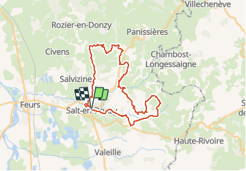
Trail Mountain bike of 30 km to be discovered at Auvergne-Rhône-Alpes, Loire, Salt-en-Donzy. This trail is proposed by tracegps.
Description
Cette randonnée "Marche et VTT en Forez" est organisée chaque année par "Solidarité Inter Associations" et ce parcours a été réalisé le dimanche 03 juin 2012. Départ du parking proche de l'école. Ce Parcours VTT d'un peu plus de 30 km est sans difficulté majeure, mais de longues ascensions useront les VTTistes les moins affûtés !!! Bien qu'il y ait d'interminables liaisons sur route, le circuit alterne les montées et les descentes et au creux des vallons, les sentiers serpentent le long des petits cours d'eau que l'on traverse soit à gué soit sur des petits ponts. Balade verte en pleine nature mais à éviter quand le terrain est gras. Guides des Montagnes du Matin : Topo-guide "Randonnée Pédestre" - 550 km de sentiers, 54 circuits au départ de 29 communes ; Nouvelle édition, Carto-guide "Itinéraires VTT" - 350 km de sentiers aménagés, 26 circuits balisés VTT (rouge).
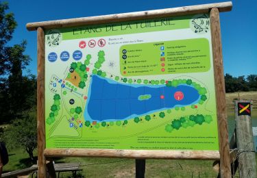
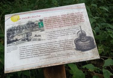
Positioning
Comments
Trails nearby
![Trail Walking Essertines-en-Donzy - Essertines en Donzy - Photo](https://media.geolcdn.com/t/375/260/846e66e1-3e4e-46d4-8aff-bf6bfe8bdd34.jpg&format=jpg&maxdim=2)
![Walking Walking](https://static1.geolcdn.com/sitytour/trail-icons/101.png)
Walking
![](/images/other/stat-length.png)
![](https://static1.geolcdn.com/siteimages/upload/files/16400158638029165_repeat_loop_refresh_sync_direction_icon.png)
![Trail Walking Salt-en-Donzy - Salt en Donzy - Photo](https://media.geolcdn.com/t/375/260/92e0799b-7397-4a83-951d-7d8dab5181d4.jpg&format=jpg&maxdim=2)
![Walking Walking](https://static1.geolcdn.com/sitytour/trail-icons/101.png)
Walking
![](/images/other/stat-length.png)
![](https://static1.geolcdn.com/siteimages/upload/files/16400158638029165_repeat_loop_refresh_sync_direction_icon.png)
![Trail Walking Feurs - Randonnée au dessus de Feurs - Photo](https://media.geolcdn.com/t/375/260/d2c52346-f2e5-4497-8257-48fbc24ee939.jpg&format=jpg&maxdim=2)
![Walking Walking](https://static1.geolcdn.com/sitytour/trail-icons/101.png)
Walking
![](/images/other/stat-length.png)
![](https://static1.geolcdn.com/siteimages/upload/files/16400158638029165_repeat_loop_refresh_sync_direction_icon.png)
![Trail Walking Valeille - Randonnée de Valeille - Photo](https://media.geolcdn.com/t/375/260/ff2b86da-5b69-4dbf-81f1-c6c051c235e0.jpg&format=jpg&maxdim=2)
![Walking Walking](https://static1.geolcdn.com/sitytour/trail-icons/101.png)
Walking
![](/images/other/stat-length.png)
![](https://static1.geolcdn.com/siteimages/upload/files/16400158638029165_repeat_loop_refresh_sync_direction_icon.png)
![Trail Walking Essertines-en-Donzy - rando à partir de l'étang de la tuilerie - Photo](https://media.geolcdn.com/t/375/260/03d3503b-ae63-4901-b6b1-fb14fd833326.jpg&format=jpg&maxdim=2)
![Walking Walking](https://static1.geolcdn.com/sitytour/trail-icons/101.png)
Walking
![](/images/other/stat-length.png)
![](https://static1.geolcdn.com/siteimages/upload/files/16400158638029165_repeat_loop_refresh_sync_direction_icon.png)
![Trail Walking Salt-en-Donzy - rando au départ de Salt en Douzy, les 3 Chapelles - Photo](https://media.geolcdn.com/t/375/260/1d587284-1cc2-4d83-a606-db22cec9330d.jpg&format=jpg&maxdim=2)
![Walking Walking](https://static1.geolcdn.com/sitytour/trail-icons/101.png)
Walking
![](/images/other/stat-length.png)
![](https://static1.geolcdn.com/siteimages/upload/files/16400158638029165_repeat_loop_refresh_sync_direction_icon.png)
![Trail Walking Salvizinet - Salvizinet, les ponts - Photo](https://media.geolcdn.com/t/375/260/c69d1521-2db8-470f-b0c0-5530cf9080dd.jpg&format=jpg&maxdim=2)
![Walking Walking](https://static1.geolcdn.com/sitytour/trail-icons/101.png)
Walking
![](/images/other/stat-length.png)
![](https://static1.geolcdn.com/siteimages/upload/files/16400158638029165_repeat_loop_refresh_sync_direction_icon.png)
![Trail Walking Salt-en-Donzy - Salt-en-Donzy, petite montagne - Photo](https://media.geolcdn.com/t/375/260/252d959a-2962-4e4a-bcee-20640b08fc82.jpg&format=jpg&maxdim=2)
![Walking Walking](https://static1.geolcdn.com/sitytour/trail-icons/101.png)
Walking
![](/images/other/stat-length.png)
![](https://static1.geolcdn.com/siteimages/upload/files/16400158638029165_repeat_loop_refresh_sync_direction_icon.png)
![Trail Walking Salt-en-Donzy - rando à Salt en Douzy, boucle autour du chemin de monorail - Photo](https://media.geolcdn.com/t/375/260/ee316358-f7a5-4d9c-844b-66185530b4f7.jpg&format=jpg&maxdim=2)
![Walking Walking](https://static1.geolcdn.com/sitytour/trail-icons/101.png)
Walking
![](/images/other/stat-length.png)
![](https://static1.geolcdn.com/siteimages/upload/files/16400158638029165_repeat_loop_refresh_sync_direction_icon.png)