![](/images/other/stat-length.png)
![Trail Walking Saint-Germain-du-Bois - Balade des Étangs - St Germain du Bois - Photo](https://media.geolcdn.com/t/1900/400/ext.pjpeg?maxdim=2&url=https%3A%2F%2Fservices.sitytrail.com%2FGeolivesWS%2FDownloadMedia.ashx%3FTrailID%3D172248%26Media%3D5917_2.jpg)
Balade des Étangs - St Germain du Bois
tracegps
User
![Length](/images/other/stat-length.png)
Length
20 km
![Max alt](https://static1.geolcdn.com/siteimages/upload/files/1508320355ic_sort_altitude_max_24dp.png)
Max alt
215 m
![Uphill gradient](https://static1.geolcdn.com/siteimages/upload/files/1508320355ic_sort_den_pos_24dp.png)
Uphill gradient
175 m
![Km-Effort](/images/other/stat-length.png)
Km-Effort
22 km
![Min alt](https://static1.geolcdn.com/siteimages/upload/files/1508320355ic_sort_altitude_min_24dp.png)
Min alt
182 m
![Downhill gradient](https://static1.geolcdn.com/siteimages/upload/files/1508320355ic_sort_den_neg_24dp.png)
Downhill gradient
177 m
![Boucle](https://static1.geolcdn.com/siteimages/upload/files/16400158638029165_repeat_loop_refresh_sync_direction_icon.png)
Boucle
Yes
Creation date :
2014-12-10 00:00:00.0
Updated on :
2014-12-10 00:00:00.0
![Walking](https://static1.geolcdn.com/sitytour/trail-icons/101.png)
4h45
Difficulty : Difficult
![Scan this QR Code to open this trail in the SityTrail application](https://capi.geolives.com/qq0zvz2zws4bq2lad0pu/sitytour/trails/172248/qr.png?size=200)
FREE GPS app for hiking
About
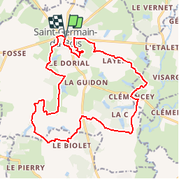
Trail Walking of 20 km to be discovered at Bourgogne-Franche-Comté, Saône-et-Loire, Saint-Germain-du-Bois. This trail is proposed by tracegps.
Description
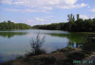
Le circuit au départ de l'église de Saint-Germain-du-Bois, permet de donner une vue sur l'ensemble des étangs au sud de la commune. Retrouvez la carte des circuits de randonnées de la commune sur le site de Saint Germain du Bois.
Positioning
Country:
France
Region :
Bourgogne-Franche-Comté
Department/Province :
Saône-et-Loire
Municipality :
Saint-Germain-du-Bois
Location:
Unknown
Start:(Dec)
Start:(UTM)
671304 ; 5180125 (31T) N.
Comments
Trails nearby
![Trail Equestrian Saint-Germain-du-Bois - Balade des Étangs - St Germain du Bois - Photo](https://media.geolcdn.com/t/375/260/ext.jpg?maxdim=2&url=https%3A%2F%2Fservices.sitytrail.com%2FGeolivesWS%2FDownloadMedia.ashx%3FTrailID%3D172250%26Media%3D5917_2.jpg)
![Equestrian Equestrian](https://static1.geolcdn.com/sitytour/trail-icons/300.png)
Balade des Étangs - St Germain du Bois
Equestrian
Difficult
Saint-Germain-du-Bois,
Bourgogne-Franche-Comté,
Saône-et-Loire,
France
![](/images/other/stat-length.png)
20 km | 22 km-effort
3h 0min
![](https://static1.geolcdn.com/siteimages/upload/files/16400158638029165_repeat_loop_refresh_sync_direction_icon.png)
Yes
![Trail Mountain bike Saint-Germain-du-Bois - Balade des Étangs - St Germain du Bois - Photo](https://media.geolcdn.com/t/375/260/ext.jpg?maxdim=2&url=https%3A%2F%2Fservices.sitytrail.com%2FGeolivesWS%2FDownloadMedia.ashx%3FTrailID%3D172249%26Media%3D5917_1.jpg)
![Mountain bike Mountain bike](https://static1.geolcdn.com/sitytour/trail-icons/202.png)
Balade des Étangs - St Germain du Bois
Mountain bike
Difficult
Saint-Germain-du-Bois,
Bourgogne-Franche-Comté,
Saône-et-Loire,
France
![](/images/other/stat-length.png)
20 km | 22 km-effort
1h 45min
![](https://static1.geolcdn.com/siteimages/upload/files/16400158638029165_repeat_loop_refresh_sync_direction_icon.png)
Yes
![Trail On foot Simard - Simard , Champ de l' étang , les Peutots , le Meix Chantrault et retour - Photo](https://media.geolcdn.com/t/375/260/ext.jpg?maxdim=2&url=https%3A%2F%2Fstatic1.geolcdn.com%2Fsiteimages%2Fupload%2Ffiles%2F1545311037marcheuse_200dpi.jpg)
![On foot On foot](https://static1.geolcdn.com/sitytour/trail-icons/100.png)
Simard , Champ de l' étang , les Peutots , le Meix Chantrault et retour
On foot
Easy
Simard,
Bourgogne-Franche-Comté,
Saône-et-Loire,
France
![](/images/other/stat-length.png)
5.5 km | 5.8 km-effort
1h 19min
![](https://static1.geolcdn.com/siteimages/upload/files/16400158638029165_repeat_loop_refresh_sync_direction_icon.png)
Yes
![Trail Walking Serley - P ou TP . Serley - La Croix - La grande Champonnière - les Vernes Thibert - et retour - Photo](https://media.geolcdn.com/t/375/260/ext.jpg?maxdim=2&url=https%3A%2F%2Fstatic1.geolcdn.com%2Fsiteimages%2Fupload%2Ffiles%2F1553511878bg_sport_marche.png)
![Walking Walking](https://static1.geolcdn.com/sitytour/trail-icons/101.png)
P ou TP . Serley - La Croix - La grande Champonnière - les Vernes Thibert - ...
Walking
Medium
Serley,
Bourgogne-Franche-Comté,
Saône-et-Loire,
France
![](/images/other/stat-length.png)
6.1 km | 6.5 km-effort
1h 28min
![](https://static1.geolcdn.com/siteimages/upload/files/16400158638029165_repeat_loop_refresh_sync_direction_icon.png)
Yes
![Trail Walking Simard - G . Simard - Les Peutots - Le Perroir - la Voirie - Les Toines - et retour - Photo](https://media.geolcdn.com/t/375/260/ext.jpg?maxdim=2&url=https%3A%2F%2Fstatic1.geolcdn.com%2Fsiteimages%2Fupload%2Ffiles%2F1553511878bg_sport_marche.png)
![Walking Walking](https://static1.geolcdn.com/sitytour/trail-icons/101.png)
G . Simard - Les Peutots - Le Perroir - la Voirie - Les Toines - et retour
Walking
Difficult
Simard,
Bourgogne-Franche-Comté,
Saône-et-Loire,
France
![](/images/other/stat-length.png)
12.9 km | 13.9 km-effort
3h 9min
![](https://static1.geolcdn.com/siteimages/upload/files/16400158638029165_repeat_loop_refresh_sync_direction_icon.png)
Yes
![Trail Walking Serley - G. Serley - Photo](https://media.geolcdn.com/t/375/260/ext.jpg?maxdim=2&url=https%3A%2F%2Fstatic1.geolcdn.com%2Fsiteimages%2Fupload%2Ffiles%2F1553511878bg_sport_marche.png)
![Walking Walking](https://static1.geolcdn.com/sitytour/trail-icons/101.png)
G. Serley
Walking
Medium
Serley,
Bourgogne-Franche-Comté,
Saône-et-Loire,
France
![](/images/other/stat-length.png)
10.2 km | 10.9 km-effort
2h 28min
![](https://static1.geolcdn.com/siteimages/upload/files/16400158638029165_repeat_loop_refresh_sync_direction_icon.png)
Yes
![Trail Road bike Saint-Germain-du-Bois - VI Roanne J3 - Photo](https://media.geolcdn.com/t/375/260/ext.jpg?maxdim=2&url=https%3A%2F%2Fstatic1.geolcdn.com%2Fsiteimages%2Fupload%2Ffiles%2F1524743154velo.jpg)
![Road bike Road bike](https://static1.geolcdn.com/sitytour/trail-icons/201.png)
VI Roanne J3
Road bike
Medium
Saint-Germain-du-Bois,
Bourgogne-Franche-Comté,
Saône-et-Loire,
France
![](/images/other/stat-length.png)
96 km | 106 km-effort
4h 23min
![](https://static1.geolcdn.com/siteimages/upload/files/16400158638029165_repeat_loop_refresh_sync_direction_icon.png)
No
![Trail Mountain bike Saint-Germain-du-Bois - Vac2021 - etape 4 bis - Photo](https://media.geolcdn.com/t/375/260/ext.jpg?maxdim=2&url=https%3A%2F%2Fstatic1.geolcdn.com%2Fsiteimages%2Fupload%2Ffiles%2F1524743154velo.jpg)
![Mountain bike Mountain bike](https://static1.geolcdn.com/sitytour/trail-icons/202.png)
Vac2021 - etape 4 bis
Mountain bike
Difficult
Saint-Germain-du-Bois,
Bourgogne-Franche-Comté,
Saône-et-Loire,
France
![](/images/other/stat-length.png)
32 km | 36 km-effort
2h 28min
![](https://static1.geolcdn.com/siteimages/upload/files/16400158638029165_repeat_loop_refresh_sync_direction_icon.png)
No
![Trail Mountain bike Saint-Germain-du-Bois - Vac2021 - Etape 4 je - Photo](https://media.geolcdn.com/t/375/260/ext.jpg?maxdim=2&url=https%3A%2F%2Fstatic1.geolcdn.com%2Fsiteimages%2Fupload%2Ffiles%2F1524743154velo.jpg)
![Mountain bike Mountain bike](https://static1.geolcdn.com/sitytour/trail-icons/202.png)
Vac2021 - Etape 4 je
Mountain bike
Very difficult
Saint-Germain-du-Bois,
Bourgogne-Franche-Comté,
Saône-et-Loire,
France
![](/images/other/stat-length.png)
43 km | 49 km-effort
3h 23min
![](https://static1.geolcdn.com/siteimages/upload/files/16400158638029165_repeat_loop_refresh_sync_direction_icon.png)
No