![](/images/other/stat-length.png)
![Trail Walking Pont de Montvert - Sud Mont Lozère - #7 GR70 Finiels - Mijavols - Photo](https://media.geolcdn.com/t/1900/400/ext.pjpeg?maxdim=2&url=https%3A%2F%2Fstatic1.geolcdn.com%2Fsiteimages%2Fupload%2Ffiles%2F1553511878bg_sport_marche.png)
#7 GR70 Finiels - Mijavols
magalette
User
![Length](/images/other/stat-length.png)
Length
21 km
![Max alt](https://static1.geolcdn.com/siteimages/upload/files/1508320355ic_sort_altitude_max_24dp.png)
Max alt
1421 m
![Uphill gradient](https://static1.geolcdn.com/siteimages/upload/files/1508320355ic_sort_den_pos_24dp.png)
Uphill gradient
713 m
![Km-Effort](/images/other/stat-length.png)
Km-Effort
31 km
![Min alt](https://static1.geolcdn.com/siteimages/upload/files/1508320355ic_sort_altitude_min_24dp.png)
Min alt
873 m
![Downhill gradient](https://static1.geolcdn.com/siteimages/upload/files/1508320355ic_sort_den_neg_24dp.png)
Downhill gradient
1017 m
![Boucle](https://static1.geolcdn.com/siteimages/upload/files/16400158638029165_repeat_loop_refresh_sync_direction_icon.png)
Boucle
No
Creation date :
2014-12-10 00:00:00.0
Updated on :
2014-12-10 00:00:00.0
![Walking](https://static1.geolcdn.com/sitytour/trail-icons/101.png)
6h20
Difficulty : Medium
![Scan this QR Code to open this trail in the SityTrail application](https://capi.geolives.com/qq0zvz2zws4bq2lad0pu/sitytour/trails/171788/qr.png?size=200)
FREE GPS app for hiking
About
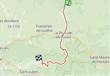
Trail Walking of 21 km to be discovered at Occitania, Lozère, Pont de Montvert - Sud Mont Lozère. This trail is proposed by magalette.
Description
7ème étape de notre randonnée sur les traces de RL Stevenson entre Finiels et Mijavols. Etape prévue au gîte d'étapes de Mijavols.
Positioning
Country:
France
Region :
Occitania
Department/Province :
Lozère
Municipality :
Pont de Montvert - Sud Mont Lozère
Location:
Le Pont-de-Montvert
Start:(Dec)
Start:(UTM)
559331 ; 4917033 (31T) N.
Comments
Trails nearby
![Trail Mountain bike Cubières - TOUR MONT LOZERE - Photo](https://media.geolcdn.com/t/375/260/a1bfdb58-8337-4d84-b53e-6cb2f940b716.jpeg&format=jpg&maxdim=2)
![Mountain bike Mountain bike](https://static1.geolcdn.com/sitytour/trail-icons/202.png)
TOUR MONT LOZERE
Mountain bike
Very difficult
(1)
Cubières,
Occitania,
Lozère,
France
![](/images/other/stat-length.png)
38 km | 47 km-effort
3h 14min
![](https://static1.geolcdn.com/siteimages/upload/files/16400158638029165_repeat_loop_refresh_sync_direction_icon.png)
Yes
![Walking Walking](https://static1.geolcdn.com/sitytour/trail-icons/101.png)
Les prairies du col de Finiels et des monts Lozere
Walking
Medium
(1)
Mont Lozère et Goulet,
Occitania,
Lozère,
France
![](/images/other/stat-length.png)
7.2 km | 9.5 km-effort
2h 59min
![](https://static1.geolcdn.com/siteimages/upload/files/16400158638029165_repeat_loop_refresh_sync_direction_icon.png)
Yes
![Trail Walking Pont de Montvert - Sud Mont Lozère - Bédoues saint jean du Gard GR70 gr43 - Photo](https://media.geolcdn.com/t/375/260/c8a87bd6-9939-4680-8373-9b7fd4cfe94c.jpg&format=jpg&maxdim=2)
![Walking Walking](https://static1.geolcdn.com/sitytour/trail-icons/101.png)
Bédoues saint jean du Gard GR70 gr43
Walking
Very difficult
Pont de Montvert - Sud Mont Lozère,
Occitania,
Lozère,
France
![](/images/other/stat-length.png)
86 km | 120 km-effort
26h 6min
![](https://static1.geolcdn.com/siteimages/upload/files/16400158638029165_repeat_loop_refresh_sync_direction_icon.png)
No
![Trail Walking Pont de Montvert - Sud Mont Lozère - Stevenson pont de Monvert/ Bedouès - Photo](https://media.geolcdn.com/t/375/260/ecbe7c42-7ae5-463d-8ef8-0e93073f446d.jpg&format=jpg&maxdim=2)
![Walking Walking](https://static1.geolcdn.com/sitytour/trail-icons/101.png)
Stevenson pont de Monvert/ Bedouès
Walking
Difficult
Pont de Montvert - Sud Mont Lozère,
Occitania,
Lozère,
France
![](/images/other/stat-length.png)
26 km | 38 km-effort
7h 29min
![](https://static1.geolcdn.com/siteimages/upload/files/16400158638029165_repeat_loop_refresh_sync_direction_icon.png)
No
![Trail Walking Pont de Montvert - Sud Mont Lozère - 13-05-2023 E8 Le Pont de Monvers - Bédouès - Photo](https://media.geolcdn.com/t/375/260/e57cdaa9-bdeb-4cef-90ee-76cf38da3fbe.jpg&format=jpg&maxdim=2)
![Walking Walking](https://static1.geolcdn.com/sitytour/trail-icons/101.png)
13-05-2023 E8 Le Pont de Monvers - Bédouès
Walking
Very difficult
Pont de Montvert - Sud Mont Lozère,
Occitania,
Lozère,
France
![](/images/other/stat-length.png)
25 km | 37 km-effort
8h 19min
![](https://static1.geolcdn.com/siteimages/upload/files/16400158638029165_repeat_loop_refresh_sync_direction_icon.png)
No
![Trail Walking Pont de Montvert - Sud Mont Lozère - Finiels/ sommet / station du Bleymard en boucle - Photo](https://media.geolcdn.com/t/375/260/f8048304-3a05-4fd0-a0e7-03457722fcee.jpg&format=jpg&maxdim=2)
![Walking Walking](https://static1.geolcdn.com/sitytour/trail-icons/101.png)
Finiels/ sommet / station du Bleymard en boucle
Walking
Difficult
Pont de Montvert - Sud Mont Lozère,
Occitania,
Lozère,
France
![](/images/other/stat-length.png)
20 km | 30 km-effort
5h 38min
![](https://static1.geolcdn.com/siteimages/upload/files/16400158638029165_repeat_loop_refresh_sync_direction_icon.png)
Yes
![Trail Walking Pont de Montvert - Sud Mont Lozère - J6 Stevenson: Pont de Monvert - Cassagnas - Photo](https://media.geolcdn.com/t/375/260/ext.jpg?maxdim=2&url=https%3A%2F%2Fstatic1.geolcdn.com%2Fsiteimages%2Fupload%2Ffiles%2F1553511878bg_sport_marche.png)
![Walking Walking](https://static1.geolcdn.com/sitytour/trail-icons/101.png)
J6 Stevenson: Pont de Monvert - Cassagnas
Walking
Medium
(1)
Pont de Montvert - Sud Mont Lozère,
Occitania,
Lozère,
France
![](/images/other/stat-length.png)
19.7 km | 29 km-effort
5h 58min
![](https://static1.geolcdn.com/siteimages/upload/files/16400158638029165_repeat_loop_refresh_sync_direction_icon.png)
No
![Trail Walking Mont Lozère et Goulet - sources du tarn - Photo](https://media.geolcdn.com/t/375/260/ext.jpg?maxdim=2&url=https%3A%2F%2Fstatic1.geolcdn.com%2Fsiteimages%2Fupload%2Ffiles%2F1553511878bg_sport_marche.png)
![Walking Walking](https://static1.geolcdn.com/sitytour/trail-icons/101.png)
sources du tarn
Walking
Medium
(1)
Mont Lozère et Goulet,
Occitania,
Lozère,
France
![](/images/other/stat-length.png)
13.3 km | 17.3 km-effort
3h 50min
![](https://static1.geolcdn.com/siteimages/upload/files/16400158638029165_repeat_loop_refresh_sync_direction_icon.png)
No
![On foot On foot](https://static1.geolcdn.com/sitytour/trail-icons/100.png)
SityTrail - lhopital
On foot
Easy
Pont de Montvert - Sud Mont Lozère,
Occitania,
Lozère,
France
![](/images/other/stat-length.png)
9.6 km | 11.8 km-effort
2h 41min
![](https://static1.geolcdn.com/siteimages/upload/files/16400158638029165_repeat_loop_refresh_sync_direction_icon.png)
No