Trail Snowshoes Le Dévoluy - Rando raquettes Devoluy - Photo
 R@ph
R@ph

User GUIDE

© OpenStreetMap contributors
Length
Length
9.5 km
Max alt
Max alt
1761 m
Uphill gradient
Uphill gradient
439 m
Km-Effort
Km-Effort  
15.4 km
Min alt
Min alt
1463 m
Downhill gradient
Downhill gradient
466 m
Boucle
Boucle
No
Creation date :
2014-12-10 00:00:00.0
Updated on :
2018-07-19 12:45:59.136

(0 Reviews)

Snowshoes
Snowshoes
4h00
Difficulty : Medium

Scan this QR Code to open this trail in the SityTrail application

FREE GPS app for hiking

Logo SityTrail SityTrail

IGN / Geographical institutes

Download SityTrail from the App Store Download SityTrail from Google Play

Logo SityTrail SityTrail World

The world is yours!

Download SityTrail from the App Store Download SityTrail from Google Play Download SityTrail on Huawei AppGallery

About

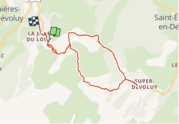
Trail Snowshoes of 9.5 km to be discovered at Provence-Alpes-Côte d'Azur, Hautes-Alpes, Le Dévoluy. This trail is proposed by R@ph.

Description

Avec une excellent neige au départ de La Joue du Loup, passage à Serre long, combe des meules, combe du Jas puis descente vers uperdevoluy.
Un petit casse croûte en terrasse tel les lézards au soleil.
Retour par le Bois des Issarts, le Collet du Tat et les Chaumates.  

Elevation profile

Positioning

Country:
France
Region :
Provence-Alpes-Côte d'Azur
Department/Province :
Hautes-Alpes
Municipality :
Le Dévoluy
Location:
Saint-Étienne-en-Dévoluy
Start:(UTM)
729521 ; 4952219 (31T) N.

Trails nearby

Trail Walking Le Dévoluy - R29   La crete des Beaumes - Photo
Walking
GUIDE+

Walking

Medium
(2)
Le Dévoluy, Provence-Alpes-Côte d'Azur, Hautes-Alpes, France
9 km | 16 km-effort
3h 17min
Yes
Trail Walking Le Dévoluy - R28   Le Col de Rabou - Photo
Walking
GUIDE+

Walking

Medium
(1)
Le Dévoluy, Provence-Alpes-Côte d'Azur, Hautes-Alpes, France
10.6 km | 17.9 km-effort
3h 52min
Yes
Trail Walking Le Dévoluy - R27   Les gorges du Rif - Photo
Walking
GUIDE+

Walking

Easy
(1)
Le Dévoluy, Provence-Alpes-Côte d'Azur, Hautes-Alpes, France
7.5 km | 11.5 km-effort
2h 27min
Yes
Trail Walking Le Dévoluy - R12   Le Col des Aiguilles - Photo
Walking
GUIDE+

Walking

Medium
(1)
Le Dévoluy, Provence-Alpes-Côte d'Azur, Hautes-Alpes, France
10.2 km | 19.2 km-effort
3h 56min
Yes
Trail Walking Le Dévoluy - R11   Cabane Rama - Photo
Walking
GUIDE+

Walking

Very easy
(4)
Le Dévoluy, Provence-Alpes-Côte d'Azur, Hautes-Alpes, France
5.5 km | 8.4 km-effort
1h 46min
Yes
Trail Walking Le Dévoluy - Cascade de Saute Aure - Photo
Walking
marmotte83

Walking

Easy
(3)
Le Dévoluy, Provence-Alpes-Côte d'Azur, Hautes-Alpes, France
7.7 km | 10.8 km-effort
3h 1min
Yes
Trail Walking Le Dévoluy - Tour du Dévoluy - Superdévoluy à Lachaup - Photo
Walking
tracegps

Walking

Medium
(1)
Le Dévoluy, Provence-Alpes-Côte d'Azur, Hautes-Alpes, France
8.3 km | 12.5 km-effort
3h 0min
No
Trail Walking Le Dévoluy - Col des Aiguilles - Photo
Walking
GUIDE
Marco05

Walking

Difficult
Le Dévoluy, Provence-Alpes-Côte d'Azur, Hautes-Alpes, France
11.3 km | 21 km-effort
4h 46min
Yes
Trail Walking Le Dévoluy - Cabane de la Rama - Photo
Walking
GUIDE
Marco05

Walking

Easy
Le Dévoluy, Provence-Alpes-Côte d'Azur, Hautes-Alpes, France
5.8 km | 8.6 km-effort
1h 56min
Yes


Close
My subscriptions