Trail Walking Loos-en-Gohelle - Terril 62 Loos en Gohelle - Photo
© OpenStreetMap contributors
Length
Length
6.1 km
Max alt
Max alt
165 m
Uphill gradient
Uphill gradient
159 m
Km-Effort
Km-Effort  
8.2 km
Min alt
Min alt
65 m
Downhill gradient
Downhill gradient
161 m
Boucle
Boucle
Yes
Creation date :
2014-12-10 00:00:00.0
Updated on :
2014-12-10 00:00:00.0

(1 Reviews)

Walking
Walking
1h43
Difficulty : Medium

Scan this QR Code to open this trail in the SityTrail application

FREE GPS app for hiking

Logo SityTrail SityTrail

IGN / Geographical institutes

Download SityTrail from the App Store Download SityTrail from Google Play

Logo SityTrail SityTrail World

The world is yours!

Download SityTrail from the App Store Download SityTrail from Google Play Download SityTrail on Huawei AppGallery

About

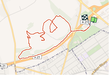
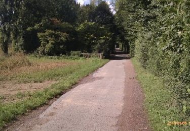
Trail Walking of 6.1 km to be discovered at Hauts-de-France, Pas-de-Calais, Loos-en-Gohelle. This trail is proposed by Bernard.voyageur.

Description

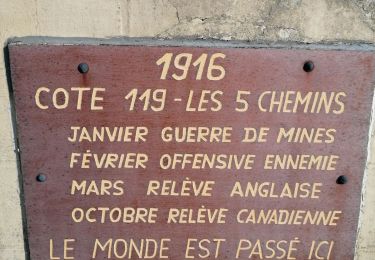
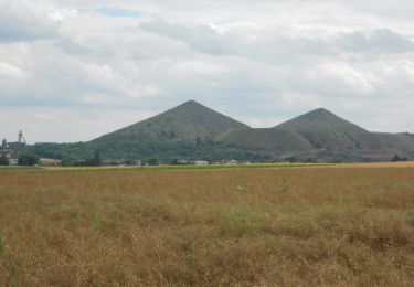
une balade sur les terrils du pas de calais

Elevation profile

Points of interest

Point of interest Loos-en-Gohelle - Piéton - Photo
Bernard.voyageur
LOOS-EN-GOHELLE 
Point of interest Loos-en-Gohelle - Piéton - Photo
Bernard.voyageur
LOOS-EN-GOHELLE 
Point of interest Loos-en-Gohelle - Piéton - Photo
Bernard.voyageur
LOOS-EN-GOHELLE 

Positioning

Country:
France
Region :
Hauts-de-France
Department/Province :
Pas-de-Calais
Municipality :
Loos-en-Gohelle
Location:
Unknown
Start:(UTM)
485217 ; 5588220 (31U) N.

Comments

Please log in to post a review or rate the element


Trails nearby

Trail Walking Liévin - 50 km Lievin en nocturne - Photo
Walking
tracegps

Walking

Very difficult
(1)
Liévin, Hauts-de-France, Pas-de-Calais, France
52 km | 61 km-effort
9h 0min
Yes
Trail Walking Lens - randonnée  - Photo
Walking
sandrine brisset

Walking

Difficult
Lens, Hauts-de-France, Pas-de-Calais, France
10.5 km | 13.4 km-effort
3h 41min
Yes
Trail Walking Angres - randonnée pinchonvalles - Photo
Walking
Chene62

Walking

Very difficult
Angres, Hauts-de-France, Pas-de-Calais, France
27 km | 0 m-effort
3h 24min
No
Trail Other activity Liévin - boucle Liévin - Photo
Other activity
crijack

Other activity

Very easy
Liévin, Hauts-de-France, Pas-de-Calais, France
11 km | 12.3 km-effort
2h 2min
Yes
Trail Other activity Liévin - boucle Liévin - Photo
Other activity
crijack

Other activity

Very easy
Liévin, Hauts-de-France, Pas-de-Calais, France
11 km | 12.3 km-effort
2h 2min
Yes
Trail Walking Vermelles - Autour de Vermellles - Photo
Walking
tracegps

Walking

Difficult
(1)
Vermelles, Hauts-de-France, Pas-de-Calais, France
15.8 km | 16.6 km-effort
4h 0min
Yes
Trail Walking Noyelles-lès-Vermelles - La voie ferrée - Noyelles-lès-Vermelles - Photo
Walking
tracegps

Walking

Difficult
Noyelles-lès-Vermelles, Hauts-de-France, Pas-de-Calais, France
13.7 km | 14.6 km-effort
3h 25min
Yes
Trail Mountain bike Angres - La randonnée VTT du Père Noël - Angres - Photo
Mountain bike
tracegps

Mountain bike

Difficult
(1)
Angres, Hauts-de-France, Pas-de-Calais, France
35 km | 42 km-effort
3h 0min
Yes
Trail Walking Aix-Noulette - Randonnée autour d' Aix Noulette - Photo
Walking
tracegps

Walking

Medium
Aix-Noulette, Hauts-de-France, Pas-de-Calais, France
8.1 km | 10.1 km-effort
1h 40min
Yes


Close
My subscriptions