Trail Walking Cailloux-sur-Fontaines - A_CAILLOUX 69270 Bas de Guillon - Boeuf Gras - Photo

A_CAILLOUX 69270 Bas de Guillon - Boeuf Gras

 ANDREJAC
ANDREJAC

User

© OpenStreetMap contributors
Length
Length
10.8 km
Max alt
Max alt
300 m
Uphill gradient
Uphill gradient
107 m
Km-Effort
Km-Effort  
12.2 km
Min alt
Min alt
237 m
Downhill gradient
Downhill gradient
108 m
Boucle
Boucle
Yes
Creation date :
2014-12-10 00:00:00.0
Updated on :
2014-12-10 00:00:00.0

(0 Reviews)

Walking
Walking
3h00
Difficulty : Easy

Scan this QR Code to open this trail in the SityTrail application

FREE GPS app for hiking

Logo SityTrail SityTrail

IGN / Geographical institutes

Download SityTrail from the App Store Download SityTrail from Google Play

Logo SityTrail SityTrail World

The world is yours!

Download SityTrail from the App Store Download SityTrail from Google Play Download SityTrail on Huawei AppGallery

About

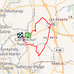
Trail Walking of 10.8 km to be discovered at Auvergne-Rhône-Alpes, Métropole de Lyon, Cailloux-sur-Fontaines. This trail is proposed by ANDREJAC.

Description

Départ de la Mairie;
La Racombe, Ruisseau des Echets, Pont TGV (264), Les Grandes Bornes, Bas du Guillon,Bois Rozet, Les Rets, Boeuf Gras, Les Epalloux, Pont TGV (298), Retour par nord de Bonnamant.

Elevation profile

Points of interest

Point of interest Cailloux-sur-Fontaines - PCF01 - Photo
ANDREJAC
CAILLOUX-SUR-FONTAINES 
Point of interest Cailloux-sur-Fontaines - PCF02 - Photo
ANDREJAC
CAILLOUX-SUR-FONTAINES 
Point of interest Rillieux-la-Pape - PCF03 - Photo
ANDREJAC
RILLIEUX-LA-PAPE 

Positioning

Country:
France
Region :
Auvergne-Rhône-Alpes
Department/Province :
Métropole de Lyon
Municipality :
Cailloux-sur-Fontaines
Location:
Unknown
Start:(UTM)
645361 ; 5079371 (31T) N.

Trails nearby

Trail Walking Couzon-au-Mont-d'Or - Tour de Couzon par les crêtes - Photo
Walking
boivin101

Walking

Difficult
(2)
Couzon-au-Mont-d'Or, Auvergne-Rhône-Alpes, Métropole de Lyon, France
6.5 km | 10.7 km-effort
2h 5min
Yes
Trail Mountain bike Collonges-au-Mont-d'Or - Tour du Mont Cindre et Mont Thoux - Photo
Mountain bike
tracegps

Mountain bike

Difficult
(3)
Collonges-au-Mont-d'Or, Auvergne-Rhône-Alpes, Métropole de Lyon, France
25 km | 33 km-effort
1h 40min
Yes
Trail Walking Couzon-au-Mont-d'Or - A_COUZON AU MT D'OR 69270  Croix Vitaise - Mont Thoux - Photo
Walking
ANDREJAC

Walking

Medium
(2)
Couzon-au-Mont-d'Or, Auvergne-Rhône-Alpes, Métropole de Lyon, France
8.5 km | 13.6 km-effort
3h 0min
Yes
Trail Mountain bike Fontaines-sur-Saône - Rando de la Madone de Fleurieu sur Saône - Photo
Mountain bike
tracegps

Mountain bike

Medium
(1)
Fontaines-sur-Saône, Auvergne-Rhône-Alpes, Métropole de Lyon, France
24 km | 30 km-effort
2h 30min
Yes
Trail Walking Saint-Cyr-au-Mont-d'Or - s3-c_st_cyr_69450_3d_homme_paysage - Photo
Walking
vidal.galaxy

Walking

Medium
(1)
Saint-Cyr-au-Mont-d'Or, Auvergne-Rhône-Alpes, Métropole de Lyon, France
6.6 km | 9.3 km-effort
2h 6min
Yes
Trail Walking Saint-Romain-au-Mont-d'Or - Saint-Romain-Au-Mont-D'Or (12 km - D. 490 m) - Photo
Walking
Thomasdanielle

Walking

Difficult
Saint-Romain-au-Mont-d'Or, Auvergne-Rhône-Alpes, Métropole de Lyon, France
11.5 km | 18 km-effort
4h 44min
Yes
Trail Walking Couzon-au-Mont-d'Or - Couzon au Mont d’Or - Photo
Walking
jeannotte

Walking

Medium
Couzon-au-Mont-d'Or, Auvergne-Rhône-Alpes, Métropole de Lyon, France
10.7 km | 15.9 km-effort
3h 26min
Yes
Trail Walking Couzon-au-Mont-d'Or - Cousin au Montd'Or - Photo
Walking
Galoche

Walking

Easy
Couzon-au-Mont-d'Or, Auvergne-Rhône-Alpes, Métropole de Lyon, France
10.7 km | 15.8 km-effort
4h 15min
Yes
Trail Walking Saint-Cyr-au-Mont-d'Or - St Cyr au Mont d'Or, le sentier des rapaces - Photo
Walking
GUIDE
VANDERPUTTENMi

Walking

Very easy
Saint-Cyr-au-Mont-d'Or, Auvergne-Rhône-Alpes, Métropole de Lyon, France
3.6 km | 5.2 km-effort
1h 8min
Yes


Close
My subscriptions