![](/images/other/stat-length.png)
![Trail Walking Bâgé-Dommartin - DOMMARTIN: Circuit de la Pérouse - Photo](https://media.geolcdn.com/t/1900/400/ext.pjpeg?maxdim=2&url=https%3A%2F%2Fstatic1.geolcdn.com%2Fsiteimages%2Fupload%2Ffiles%2F1553511878bg_sport_marche.png)
DOMMARTIN: Circuit de la Pérouse
robertdurand
User
![Length](/images/other/stat-length.png)
Length
7.7 km
![Max alt](https://static1.geolcdn.com/siteimages/upload/files/1508320355ic_sort_altitude_max_24dp.png)
Max alt
209 m
![Uphill gradient](https://static1.geolcdn.com/siteimages/upload/files/1508320355ic_sort_den_pos_24dp.png)
Uphill gradient
75 m
![Km-Effort](/images/other/stat-length.png)
Km-Effort
8.7 km
![Min alt](https://static1.geolcdn.com/siteimages/upload/files/1508320355ic_sort_altitude_min_24dp.png)
Min alt
185 m
![Downhill gradient](https://static1.geolcdn.com/siteimages/upload/files/1508320355ic_sort_den_neg_24dp.png)
Downhill gradient
75 m
![Boucle](https://static1.geolcdn.com/siteimages/upload/files/16400158638029165_repeat_loop_refresh_sync_direction_icon.png)
Boucle
Yes
Creation date :
2014-12-10 00:00:00.0
Updated on :
2014-12-10 00:00:00.0
![Walking](https://static1.geolcdn.com/sitytour/trail-icons/101.png)
1h55
Difficulty : Easy
![Scan this QR Code to open this trail in the SityTrail application](https://capi.geolives.com/qq0zvz2zws4bq2lad0pu/sitytour/trails/165343/qr.png?size=200)
FREE GPS app for hiking
About
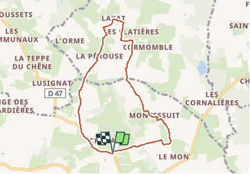
Trail Walking of 7.7 km to be discovered at Auvergne-Rhône-Alpes, Ain, Bâgé-Dommartin. This trail is proposed by robertdurand.
Description
Randonnées au Pays de Bâgé: ce circuit permet de découvrir une authentique maison seigneurale, un vieux moulin et deux cheminées sarrasines.
(Randonnée de la communauté du pays de Bâgé)
Positioning
Country:
France
Region :
Auvergne-Rhône-Alpes
Department/Province :
Ain
Municipality :
Bâgé-Dommartin
Location:
Dommartin
Start:(Dec)
Start:(UTM)
653171 ; 5134472 (31T) N.
Comments
Trails nearby
![Trail Walking Chevroux - Chevroux - Photo](https://media.geolcdn.com/t/375/260/ext.jpg?maxdim=2&url=https%3A%2F%2Fstatic1.geolcdn.com%2Fsiteimages%2Fupload%2Ffiles%2F1553511878bg_sport_marche.png)
![Walking Walking](https://static1.geolcdn.com/sitytour/trail-icons/101.png)
Chevroux
Walking
Medium
Chevroux,
Auvergne-Rhône-Alpes,
Ain,
France
![](/images/other/stat-length.png)
6.7 km | 7.4 km-effort
1h 36min
![](https://static1.geolcdn.com/siteimages/upload/files/16400158638029165_repeat_loop_refresh_sync_direction_icon.png)
Yes
![Trail Walking Saint-Sulpice - Ballades des Papilles 2013à St Didier D'Aussiat - Photo](https://media.geolcdn.com/t/375/260/ext.jpg?maxdim=2&url=https%3A%2F%2Fstatic1.geolcdn.com%2Fsiteimages%2Fupload%2Ffiles%2F1553511878bg_sport_marche.png)
![Walking Walking](https://static1.geolcdn.com/sitytour/trail-icons/101.png)
Ballades des Papilles 2013à St Didier D'Aussiat
Walking
Medium
Saint-Sulpice,
Auvergne-Rhône-Alpes,
Ain,
France
![](/images/other/stat-length.png)
15.7 km | 17.9 km-effort
3h 55min
![](https://static1.geolcdn.com/siteimages/upload/files/16400158638029165_repeat_loop_refresh_sync_direction_icon.png)
Yes
![Trail Walking Bâgé-Dommartin - DOMMARTIN: Circuit Épaisse - Photo](https://media.geolcdn.com/t/375/260/ext.jpg?maxdim=2&url=https%3A%2F%2Fstatic1.geolcdn.com%2Fsiteimages%2Fupload%2Ffiles%2F1553511878bg_sport_marche.png)
![Walking Walking](https://static1.geolcdn.com/sitytour/trail-icons/101.png)
DOMMARTIN: Circuit Épaisse
Walking
Medium
Bâgé-Dommartin,
Auvergne-Rhône-Alpes,
Ain,
France
![](/images/other/stat-length.png)
16.1 km | 18 km-effort
4h 8min
![](https://static1.geolcdn.com/siteimages/upload/files/16400158638029165_repeat_loop_refresh_sync_direction_icon.png)
Yes
![Trail Walking Bâgé-Dommartin - Dommartin: le Circuit des Nénuphars - Photo](https://media.geolcdn.com/t/375/260/ext.jpg?maxdim=2&url=https%3A%2F%2Fstatic1.geolcdn.com%2Fsiteimages%2Fupload%2Ffiles%2F1553511878bg_sport_marche.png)
![Walking Walking](https://static1.geolcdn.com/sitytour/trail-icons/101.png)
Dommartin: le Circuit des Nénuphars
Walking
Very easy
Bâgé-Dommartin,
Auvergne-Rhône-Alpes,
Ain,
France
![](/images/other/stat-length.png)
6.5 km | 7.2 km-effort
1h 36min
![](https://static1.geolcdn.com/siteimages/upload/files/16400158638029165_repeat_loop_refresh_sync_direction_icon.png)
Yes
![Trail Walking Bâgé-le-Châtel - Bâgé-la Ville: Pailladières - Photo](https://media.geolcdn.com/t/375/260/ext.jpg?maxdim=2&url=https%3A%2F%2Fstatic1.geolcdn.com%2Fsiteimages%2Fupload%2Ffiles%2F1553511878bg_sport_marche.png)
![Walking Walking](https://static1.geolcdn.com/sitytour/trail-icons/101.png)
Bâgé-la Ville: Pailladières
Walking
Difficult
Bâgé-le-Châtel,
Auvergne-Rhône-Alpes,
Ain,
France
![](/images/other/stat-length.png)
27 km | 30 km-effort
7h 2min
![](https://static1.geolcdn.com/siteimages/upload/files/16400158638029165_repeat_loop_refresh_sync_direction_icon.png)
Yes
![Trail Walking Bâgé-le-Châtel - Bâgé-le Chatel: les 3 Châteaux - Photo](https://media.geolcdn.com/t/375/260/ext.jpg?maxdim=2&url=https%3A%2F%2Fstatic1.geolcdn.com%2Fsiteimages%2Fupload%2Ffiles%2F1553511878bg_sport_marche.png)
![Walking Walking](https://static1.geolcdn.com/sitytour/trail-icons/101.png)
Bâgé-le Chatel: les 3 Châteaux
Walking
Easy
Bâgé-le-Châtel,
Auvergne-Rhône-Alpes,
Ain,
France
![](/images/other/stat-length.png)
11.1 km | 12.9 km-effort
2h 30min
![](https://static1.geolcdn.com/siteimages/upload/files/16400158638029165_repeat_loop_refresh_sync_direction_icon.png)
Yes
![Trail On foot Chevroux - CHEVROUX - Photo](https://media.geolcdn.com/t/375/260/ext.jpg?maxdim=2&url=https%3A%2F%2Fstatic1.geolcdn.com%2Fsiteimages%2Fupload%2Ffiles%2F1545311037marcheuse_200dpi.jpg)
![On foot On foot](https://static1.geolcdn.com/sitytour/trail-icons/100.png)
CHEVROUX
On foot
Easy
Chevroux,
Auvergne-Rhône-Alpes,
Ain,
France
![](/images/other/stat-length.png)
12.5 km | 13.9 km-effort
3h 9min
![](https://static1.geolcdn.com/siteimages/upload/files/16400158638029165_repeat_loop_refresh_sync_direction_icon.png)
Yes