![](/images/other/stat-length.png)
![Trail Walking Bâgé-le-Châtel - Bâgé-le Chatel: les 3 Châteaux - Photo](https://media.geolcdn.com/t/1900/400/ext.pjpeg?maxdim=2&url=https%3A%2F%2Fstatic1.geolcdn.com%2Fsiteimages%2Fupload%2Ffiles%2F1553511878bg_sport_marche.png)
Bâgé-le Chatel: les 3 Châteaux
robertdurand
User
![Length](/images/other/stat-length.png)
Length
11.1 km
![Max alt](https://static1.geolcdn.com/siteimages/upload/files/1508320355ic_sort_altitude_max_24dp.png)
Max alt
213 m
![Uphill gradient](https://static1.geolcdn.com/siteimages/upload/files/1508320355ic_sort_den_pos_24dp.png)
Uphill gradient
137 m
![Km-Effort](/images/other/stat-length.png)
Km-Effort
12.9 km
![Min alt](https://static1.geolcdn.com/siteimages/upload/files/1508320355ic_sort_altitude_min_24dp.png)
Min alt
184 m
![Downhill gradient](https://static1.geolcdn.com/siteimages/upload/files/1508320355ic_sort_den_neg_24dp.png)
Downhill gradient
137 m
![Boucle](https://static1.geolcdn.com/siteimages/upload/files/16400158638029165_repeat_loop_refresh_sync_direction_icon.png)
Boucle
Yes
Creation date :
2014-12-10 00:00:00.0
Updated on :
2014-12-10 00:00:00.0
![Walking](https://static1.geolcdn.com/sitytour/trail-icons/101.png)
2h30
Difficulty : Easy
![Scan this QR Code to open this trail in the SityTrail application](https://capi.geolives.com/qq0zvz2zws4bq2lad0pu/sitytour/trails/165268/qr.png?size=200)
FREE GPS app for hiking
About
Trail Walking of 11.1 km to be discovered at Auvergne-Rhône-Alpes, Ain, Bâgé-le-Châtel. This trail is proposed by robertdurand.
Description
La communauté de communes du pays de Bâgé propose un circuit qui permet de voir les Châteaux de Bâgé-le-Châtel, de Montépin et de la Grifonnière
Positioning
Country:
France
Region :
Auvergne-Rhône-Alpes
Department/Province :
Ain
Municipality :
Bâgé-le-Châtel
Location:
Unknown
Start:(Dec)
Start:(UTM)
648545 ; 5130050 (31T) N.
Comments
Trails nearby
![Trail sport Replonges - 2023-12-17_13h47m13_retour_a_laiz-18080067-1702813386-845-1 - Photo](https://media.geolcdn.com/t/375/260/ext.jpg?maxdim=2&url=https%3A%2F%2Fsecurestorage.geolives.com%2Fsitytour%2Ftrail-bg%2Fdefault.jpg)
2023-12-17_13h47m13_retour_a_laiz-18080067-1702813386-845-1
sport
Very easy
(1)
Replonges,
Auvergne-Rhône-Alpes,
Ain,
France
![](/images/other/stat-length.png)
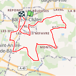
17.9 km | 19.8 km-effort
Unknown
![](https://static1.geolcdn.com/siteimages/upload/files/16400158638029165_repeat_loop_refresh_sync_direction_icon.png)
No
![Trail Walking Feillens - Montgrimoux chevroux - Photo](https://media.geolcdn.com/t/375/260/544a8d18-5696-47fa-bcdd-36ca64648de3.jpg&format=jpg&maxdim=2)
![Walking Walking](https://static1.geolcdn.com/sitytour/trail-icons/101.png)
Montgrimoux chevroux
Walking
Difficult
Feillens,
Auvergne-Rhône-Alpes,
Ain,
France
![](/images/other/stat-length.png)
14.2 km | 15.7 km-effort
3h 7min
![](https://static1.geolcdn.com/siteimages/upload/files/16400158638029165_repeat_loop_refresh_sync_direction_icon.png)
Yes
![Trail Walking Crottet - Ballade autour de CROTTET - Photo](https://media.geolcdn.com/t/375/260/ext.jpg?maxdim=2&url=https%3A%2F%2Fstatic1.geolcdn.com%2Fsiteimages%2Fupload%2Ffiles%2F1553511878bg_sport_marche.png)
![Walking Walking](https://static1.geolcdn.com/sitytour/trail-icons/101.png)
Ballade autour de CROTTET
Walking
Crottet,
Auvergne-Rhône-Alpes,
Ain,
France
![](/images/other/stat-length.png)
5.2 km | 5.7 km-effort
1h 21min
![](https://static1.geolcdn.com/siteimages/upload/files/16400158638029165_repeat_loop_refresh_sync_direction_icon.png)
Yes
![Trail Walking Feillens - balade du jour - Photo](https://media.geolcdn.com/t/375/260/ext.jpg?maxdim=2&url=https%3A%2F%2Fstatic1.geolcdn.com%2Fsiteimages%2Fupload%2Ffiles%2F1553511878bg_sport_marche.png)
![Walking Walking](https://static1.geolcdn.com/sitytour/trail-icons/101.png)
balade du jour
Walking
Medium
Feillens,
Auvergne-Rhône-Alpes,
Ain,
France
![](/images/other/stat-length.png)
9.9 km | 11 km-effort
2h 4min
![](https://static1.geolcdn.com/siteimages/upload/files/16400158638029165_repeat_loop_refresh_sync_direction_icon.png)
Yes
![Trail Walking Replonges - la découverte de replonge - Photo](https://media.geolcdn.com/t/375/260/ext.jpg?maxdim=2&url=https%3A%2F%2Fstatic1.geolcdn.com%2Fsiteimages%2Fupload%2Ffiles%2F1553511878bg_sport_marche.png)
![Walking Walking](https://static1.geolcdn.com/sitytour/trail-icons/101.png)
la découverte de replonge
Walking
Medium
Replonges,
Auvergne-Rhône-Alpes,
Ain,
France
![](/images/other/stat-length.png)
12.3 km | 13.4 km-effort
2h 42min
![](https://static1.geolcdn.com/siteimages/upload/files/16400158638029165_repeat_loop_refresh_sync_direction_icon.png)
Yes
![Trail Walking Pont-de-Veyle - Crottet Laiz - Photo](https://media.geolcdn.com/t/375/260/ext.jpg?maxdim=2&url=https%3A%2F%2Fstatic1.geolcdn.com%2Fsiteimages%2Fupload%2Ffiles%2F1553511878bg_sport_marche.png)
![Walking Walking](https://static1.geolcdn.com/sitytour/trail-icons/101.png)
Crottet Laiz
Walking
Medium
Pont-de-Veyle,
Auvergne-Rhône-Alpes,
Ain,
France
![](/images/other/stat-length.png)
11.1 km | 12.3 km-effort
2h 40min
![](https://static1.geolcdn.com/siteimages/upload/files/16400158638029165_repeat_loop_refresh_sync_direction_icon.png)
No
![Trail Walking Pont-de-Veyle - Grièges - Photo](https://media.geolcdn.com/t/375/260/ext.jpg?maxdim=2&url=https%3A%2F%2Fstatic1.geolcdn.com%2Fsiteimages%2Fupload%2Ffiles%2F1553511878bg_sport_marche.png)
![Walking Walking](https://static1.geolcdn.com/sitytour/trail-icons/101.png)
Grièges
Walking
Medium
Pont-de-Veyle,
Auvergne-Rhône-Alpes,
Ain,
France
![](/images/other/stat-length.png)
12.7 km | 13.8 km-effort
2h 52min
![](https://static1.geolcdn.com/siteimages/upload/files/16400158638029165_repeat_loop_refresh_sync_direction_icon.png)
No
![Trail Walking Feillens - Balade dans les bois de FEILLENS - Photo](https://media.geolcdn.com/t/375/260/ext.jpg?maxdim=2&url=https%3A%2F%2Fstatic1.geolcdn.com%2Fsiteimages%2Fupload%2Ffiles%2F1553511878bg_sport_marche.png)
![Walking Walking](https://static1.geolcdn.com/sitytour/trail-icons/101.png)
Balade dans les bois de FEILLENS
Walking
Feillens,
Auvergne-Rhône-Alpes,
Ain,
France
![](/images/other/stat-length.png)
4.4 km | 4.9 km-effort
1h 14min
![](https://static1.geolcdn.com/siteimages/upload/files/16400158638029165_repeat_loop_refresh_sync_direction_icon.png)
Yes
![Trail Walking Saint-Jean-sur-Veyle - 20171231 Saint Jean Laiz - Photo](https://media.geolcdn.com/t/375/260/ext.jpg?maxdim=2&url=https%3A%2F%2Fservices.sitytrail.com%2FGeolivesWS%2FDownloadMedia.ashx%3FTrailID%3D881247%26Media%3Dfix__20171231131451.jpg)
![Walking Walking](https://static1.geolcdn.com/sitytour/trail-icons/101.png)
20171231 Saint Jean Laiz
Walking
Very easy
Saint-Jean-sur-Veyle,
Auvergne-Rhône-Alpes,
Ain,
France
![](/images/other/stat-length.png)
8 km | 8.7 km-effort
1h 55min
![](https://static1.geolcdn.com/siteimages/upload/files/16400158638029165_repeat_loop_refresh_sync_direction_icon.png)
Yes