![](/images/other/stat-length.png)
![Trail Running Saint-Étienne - SaintéLyon 2012 - Photo](https://media.geolcdn.com/t/1900/400/ext.pjpeg?maxdim=2&url=https%3A%2F%2Fstatic1.geolcdn.com%2Fsiteimages%2Fupload%2Ffiles%2F1524743154running.jpg)
SaintéLyon 2012
Valery01
User
![Length](/images/other/stat-length.png)
Length
71 km
![Max alt](https://static1.geolcdn.com/siteimages/upload/files/1508320355ic_sort_altitude_max_24dp.png)
Max alt
892 m
![Uphill gradient](https://static1.geolcdn.com/siteimages/upload/files/1508320355ic_sort_den_pos_24dp.png)
Uphill gradient
1555 m
![Km-Effort](/images/other/stat-length.png)
Km-Effort
93 km
![Min alt](https://static1.geolcdn.com/siteimages/upload/files/1508320355ic_sort_altitude_min_24dp.png)
Min alt
160 m
![Downhill gradient](https://static1.geolcdn.com/siteimages/upload/files/1508320355ic_sort_den_neg_24dp.png)
Downhill gradient
1882 m
![Boucle](https://static1.geolcdn.com/siteimages/upload/files/16400158638029165_repeat_loop_refresh_sync_direction_icon.png)
Boucle
No
Creation date :
2014-12-10 00:00:00.0
Updated on :
2014-12-10 00:00:00.0
![Running](https://static1.geolcdn.com/sitytour/trail-icons/103.png)
10h00
Difficulty : Very difficult
![Scan this QR Code to open this trail in the SityTrail application](https://capi.geolives.com/qq0zvz2zws4bq2lad0pu/sitytour/trails/164742/qr.png?size=200)
FREE GPS app for hiking
About
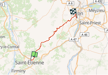
Trail Running of 71 km to be discovered at Auvergne-Rhône-Alpes, Loire, Saint-Étienne. This trail is proposed by Valery01.
Description
La tres connue SaintéLyon relis Saint Etienne à Lyon en course à pied individuel ou en relais ou mache de nuit le premier samedi de décembre de 0H00 à 15H00 max
Positioning
Country:
France
Region :
Auvergne-Rhône-Alpes
Department/Province :
Loire
Municipality :
Saint-Étienne
Location:
Unknown
Start:(Dec)
Start:(UTM)
609347 ; 5033947 (31T) N.
Comments
Trails nearby
![Trail Mountain bike Saint-Genest-Lerpt - Rando VTT Les Balades d'automne - Saint Genest Lerpt - Photo](https://media.geolcdn.com/t/375/260/ext.jpg?maxdim=2&url=https%3A%2F%2Fservices.sitytrail.com%2FGeolivesWS%2FDownloadMedia.ashx%3FTrailID%3D107357%26Media%3D12248_6.jpg)
![Mountain bike Mountain bike](https://static1.geolcdn.com/sitytour/trail-icons/202.png)
Rando VTT Les Balades d'automne - Saint Genest Lerpt
Mountain bike
Very difficult
(1)
Saint-Genest-Lerpt,
Auvergne-Rhône-Alpes,
Loire,
France
![](/images/other/stat-length.png)
49 km | 63 km-effort
3h 30min
![](https://static1.geolcdn.com/siteimages/upload/files/16400158638029165_repeat_loop_refresh_sync_direction_icon.png)
Yes
![Trail Running Saint-Étienne - camps egauds ND Hermitage GR7 jasserie perdrix bessat Salvaris camps - Photo](https://media.geolcdn.com/t/375/260/ext.jpg?maxdim=2&url=https%3A%2F%2Fservices.sitytrail.com%2FGeolivesWS%2FDownloadMedia.ashx%3FTrailID%3D360800%26Media%3Dfix__20141107194013.jpg)
![Running Running](https://static1.geolcdn.com/sitytour/trail-icons/103.png)
camps egauds ND Hermitage GR7 jasserie perdrix bessat Salvaris camps
Running
Difficult
(1)
Saint-Étienne,
Auvergne-Rhône-Alpes,
Loire,
France
![](/images/other/stat-length.png)
39 km | 61 km-effort
4h 57min
![](https://static1.geolcdn.com/siteimages/upload/files/16400158638029165_repeat_loop_refresh_sync_direction_icon.png)
Yes
![Trail Walking Saint-Étienne - Château de Rochetaillé - Photo](https://media.geolcdn.com/t/375/260/0a62acf5-7a99-4c66-90fd-20705d7d3753.jpg&format=jpg&maxdim=2)
![Walking Walking](https://static1.geolcdn.com/sitytour/trail-icons/101.png)
Château de Rochetaillé
Walking
Easy
Saint-Étienne,
Auvergne-Rhône-Alpes,
Loire,
France
![](/images/other/stat-length.png)
4.9 km | 7.7 km-effort
1h 15min
![](https://static1.geolcdn.com/siteimages/upload/files/16400158638029165_repeat_loop_refresh_sync_direction_icon.png)
Yes
![Trail Walking Sorbiers - Randonnée au dessus de Sorbiers - Photo](https://media.geolcdn.com/t/375/260/a6bbe919-adb1-45cb-b135-8681461c4bcc.jpg&format=jpg&maxdim=2)
![Walking Walking](https://static1.geolcdn.com/sitytour/trail-icons/101.png)
Randonnée au dessus de Sorbiers
Walking
Medium
Sorbiers,
Auvergne-Rhône-Alpes,
Loire,
France
![](/images/other/stat-length.png)
16.4 km | 24 km-effort
4h 24min
![](https://static1.geolcdn.com/siteimages/upload/files/16400158638029165_repeat_loop_refresh_sync_direction_icon.png)
Yes
![Trail On foot Saint-Étienne - Voie Verte Terrasse-Bellevue - Photo](https://media.geolcdn.com/t/375/260/96d4883c-d9c8-402a-9eb6-5267c2e74d6f.jpeg&format=jpg&maxdim=2)
![On foot On foot](https://static1.geolcdn.com/sitytour/trail-icons/100.png)
Voie Verte Terrasse-Bellevue
On foot
Easy
Saint-Étienne,
Auvergne-Rhône-Alpes,
Loire,
France
![](/images/other/stat-length.png)
10.8 km | 14.6 km-effort
3h 18min
![](https://static1.geolcdn.com/siteimages/upload/files/16400158638029165_repeat_loop_refresh_sync_direction_icon.png)
No
![Trail Motor Villars - Loire, Haute Loire, Ardèche - Photo](https://media.geolcdn.com/t/375/260/ext.jpg?maxdim=2&url=https%3A%2F%2Fstatic1.geolcdn.com%2Fsiteimages%2Fupload%2Ffiles%2F15247431544x4.jpg)
![Motor Motor](https://static1.geolcdn.com/sitytour/trail-icons/400.png)
Loire, Haute Loire, Ardèche
Motor
Easy
(1)
Villars,
Auvergne-Rhône-Alpes,
Loire,
France
![](/images/other/stat-length.png)
342 km | 442 km-effort
5h 0min
![](https://static1.geolcdn.com/siteimages/upload/files/16400158638029165_repeat_loop_refresh_sync_direction_icon.png)
Yes
![Trail Running Saint-Étienne - salvaris sans bitume v0 - Photo](https://media.geolcdn.com/t/375/260/ext.jpg?maxdim=2&url=https%3A%2F%2Fservices.sitytrail.com%2FGeolivesWS%2FDownloadMedia.ashx%3FTrailID%3D372159%26Media%3Dfix__20141223125609.jpg)
![Running Running](https://static1.geolcdn.com/sitytour/trail-icons/103.png)
salvaris sans bitume v0
Running
Medium
(1)
Saint-Étienne,
Auvergne-Rhône-Alpes,
Loire,
France
![](/images/other/stat-length.png)
10.9 km | 20 km-effort
1h 28min
![](https://static1.geolcdn.com/siteimages/upload/files/16400158638029165_repeat_loop_refresh_sync_direction_icon.png)
Yes
![Trail Walking Saint-Étienne - Le tour du bois D'aveze - Photo](https://media.geolcdn.com/t/375/260/76307f56-cc46-4756-817b-5159e9dca1d2.jpg&format=jpg&maxdim=2)
![Walking Walking](https://static1.geolcdn.com/sitytour/trail-icons/101.png)
Le tour du bois D'aveze
Walking
Very easy
Saint-Étienne,
Auvergne-Rhône-Alpes,
Loire,
France
![](/images/other/stat-length.png)
3.7 km | 5.3 km-effort
1h 31min
![](https://static1.geolcdn.com/siteimages/upload/files/16400158638029165_repeat_loop_refresh_sync_direction_icon.png)
Yes
![Trail Walking Saint-Étienne - st Étienne -le bessat - Photo](https://media.geolcdn.com/t/375/260/ext.jpg?maxdim=2&url=https%3A%2F%2Fstatic1.geolcdn.com%2Fsiteimages%2Fupload%2Ffiles%2F1553511878bg_sport_marche.png)
![Walking Walking](https://static1.geolcdn.com/sitytour/trail-icons/101.png)
st Étienne -le bessat
Walking
Medium
(1)
Saint-Étienne,
Auvergne-Rhône-Alpes,
Loire,
France
![](/images/other/stat-length.png)
32 km | 45 km-effort
6h 4min
![](https://static1.geolcdn.com/siteimages/upload/files/16400158638029165_repeat_loop_refresh_sync_direction_icon.png)
Yes