![](/images/other/stat-length.png)
![Trail Walking Ternand - Forêt de Brou col des roches Blanches - Photo](https://media.geolcdn.com/t/1900/400/ext.pjpeg?maxdim=2&url=https%3A%2F%2Fstatic1.geolcdn.com%2Fsiteimages%2Fupload%2Ffiles%2F1553511878bg_sport_marche.png)
Forêt de Brou col des roches Blanches
picvert09
User
![Length](/images/other/stat-length.png)
Length
11.8 km
![Max alt](https://static1.geolcdn.com/siteimages/upload/files/1508320355ic_sort_altitude_max_24dp.png)
Max alt
750 m
![Uphill gradient](https://static1.geolcdn.com/siteimages/upload/files/1508320355ic_sort_den_pos_24dp.png)
Uphill gradient
558 m
![Km-Effort](/images/other/stat-length.png)
Km-Effort
19.3 km
![Min alt](https://static1.geolcdn.com/siteimages/upload/files/1508320355ic_sort_altitude_min_24dp.png)
Min alt
371 m
![Downhill gradient](https://static1.geolcdn.com/siteimages/upload/files/1508320355ic_sort_den_neg_24dp.png)
Downhill gradient
558 m
![Boucle](https://static1.geolcdn.com/siteimages/upload/files/16400158638029165_repeat_loop_refresh_sync_direction_icon.png)
Boucle
Yes
Creation date :
2014-12-10 00:00:00.0
Updated on :
2014-12-10 00:00:00.0
![Walking](https://static1.geolcdn.com/sitytour/trail-icons/101.png)
4h00
Difficulty : Medium
![Scan this QR Code to open this trail in the SityTrail application](https://capi.geolives.com/qq0zvz2zws4bq2lad0pu/sitytour/trails/163038/qr.png?size=200)
FREE GPS app for hiking
About
Trail Walking of 11.8 km to be discovered at Auvergne-Rhône-Alpes, Rhône, Ternand. This trail is proposed by picvert09.
Description
Un circuit qui démarre dans les vignes mais qui est majoritairement en forêt
Prévoir des chaussures de marches car beaucoup de cailloux sur les sentiers
Positioning
Country:
France
Region :
Auvergne-Rhône-Alpes
Department/Province :
Rhône
Municipality :
Ternand
Location:
Unknown
Start:(Dec)
Start:(UTM)
617095 ; 5089439 (31T) N.
Comments
Trails nearby
![Trail Walking Ternand - 2022-04-07_21h47m08_Ternand_V2 - Photo](https://media.geolcdn.com/t/375/260/d73b31f3-847d-4c86-9759-810d2e04500a.jpg&format=jpg&maxdim=2)
![Walking Walking](https://static1.geolcdn.com/sitytour/trail-icons/101.png)
2022-04-07_21h47m08_Ternand_V2
Walking
Very difficult
(1)
Ternand,
Auvergne-Rhône-Alpes,
Rhône,
France
![](/images/other/stat-length.png)
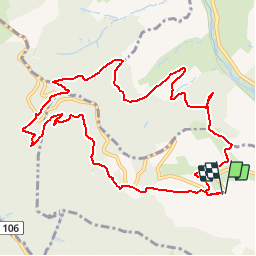
17.8 km | 27 km-effort
6h 7min
![](https://static1.geolcdn.com/siteimages/upload/files/16400158638029165_repeat_loop_refresh_sync_direction_icon.png)
Yes
![Trail Walking Saint-Vérand - Saint Vérand - Photo](https://media.geolcdn.com/t/375/260/ext.jpg?maxdim=2&url=https%3A%2F%2Fstatic1.geolcdn.com%2Fsiteimages%2Fupload%2Ffiles%2F1553511878bg_sport_marche.png)
![Walking Walking](https://static1.geolcdn.com/sitytour/trail-icons/101.png)
Saint Vérand
Walking
Medium
(1)
Saint-Vérand,
Auvergne-Rhône-Alpes,
Rhône,
France
![](/images/other/stat-length.png)
13.5 km | 21 km-effort
3h 37min
![](https://static1.geolcdn.com/siteimages/upload/files/16400158638029165_repeat_loop_refresh_sync_direction_icon.png)
Yes
![Trail Walking Dième - Le Ruisseau de Brou - Photo](https://media.geolcdn.com/t/375/260/ext.jpg?maxdim=2&url=https%3A%2F%2Fstatic1.geolcdn.com%2Fsiteimages%2Fupload%2Ffiles%2F1553511878bg_sport_marche.png)
![Walking Walking](https://static1.geolcdn.com/sitytour/trail-icons/101.png)
Le Ruisseau de Brou
Walking
Medium
(1)
Dième,
Auvergne-Rhône-Alpes,
Rhône,
France
![](/images/other/stat-length.png)
11.3 km | 17.3 km-effort
3h 24min
![](https://static1.geolcdn.com/siteimages/upload/files/16400158638029165_repeat_loop_refresh_sync_direction_icon.png)
Yes
![Trail Walking Sainte-Paule - Sainte-Paule (13,4 km D. 485 m) - Photo](https://media.geolcdn.com/t/375/260/ext.jpg?maxdim=2&url=https%3A%2F%2Fstatic1.geolcdn.com%2Fsiteimages%2Fupload%2Ffiles%2F1553511878bg_sport_marche.png)
![Walking Walking](https://static1.geolcdn.com/sitytour/trail-icons/101.png)
Sainte-Paule (13,4 km D. 485 m)
Walking
Medium
(1)
Sainte-Paule,
Auvergne-Rhône-Alpes,
Rhône,
France
![](/images/other/stat-length.png)
13.4 km | 19.4 km-effort
4h 9min
![](https://static1.geolcdn.com/siteimages/upload/files/16400158638029165_repeat_loop_refresh_sync_direction_icon.png)
Yes
![Trail Walking Val d'Oingt - 69620-StLo-160412-Azergues+Genetière+Berthier - Photo](https://media.geolcdn.com/t/375/260/ext.jpg?maxdim=2&url=https%3A%2F%2Fstatic1.geolcdn.com%2Fsiteimages%2Fupload%2Ffiles%2F1553511878bg_sport_marche.png)
![Walking Walking](https://static1.geolcdn.com/sitytour/trail-icons/101.png)
69620-StLo-160412-Azergues+Genetière+Berthier
Walking
Easy
(2)
Val d'Oingt,
Auvergne-Rhône-Alpes,
Rhône,
France
![](/images/other/stat-length.png)
5.2 km | 7.1 km-effort
1h 38min
![](https://static1.geolcdn.com/siteimages/upload/files/16400158638029165_repeat_loop_refresh_sync_direction_icon.png)
Yes
![Walking Walking](https://static1.geolcdn.com/sitytour/trail-icons/101.png)
Saint-Laurent d'Oingt - Oingt, Plus beau Village de France
Walking
Difficult
Val d'Oingt,
Auvergne-Rhône-Alpes,
Rhône,
France
![](/images/other/stat-length.png)
8.8 km | 12.5 km-effort
2h 20min
![](https://static1.geolcdn.com/siteimages/upload/files/16400158638029165_repeat_loop_refresh_sync_direction_icon.png)
Yes
![Trail Walking Val d'Oingt - 69620-Saint-Laurent d'Oingt-Bois d'Oingt : lavoirs, château et coteaux - Photo](https://media.geolcdn.com/t/375/260/f3b7e635-4f2d-4ecb-b5c7-b81cf631e86a.jpg&format=jpg&maxdim=2)
![Walking Walking](https://static1.geolcdn.com/sitytour/trail-icons/101.png)
69620-Saint-Laurent d'Oingt-Bois d'Oingt : lavoirs, château et coteaux
Walking
Medium
Val d'Oingt,
Auvergne-Rhône-Alpes,
Rhône,
France
![](/images/other/stat-length.png)
8 km | 11 km-effort
1h 57min
![](https://static1.geolcdn.com/siteimages/upload/files/16400158638029165_repeat_loop_refresh_sync_direction_icon.png)
Yes
![Trail Walking Val d'Oingt - Trail & Rando de](https://media.geolcdn.com/t/375/260/e8df058e-c2da-4e2a-813f-f16a55ee167c.jpg&format=jpg&maxdim=2)
![Walking Walking](https://static1.geolcdn.com/sitytour/trail-icons/101.png)
Trail & Rando de "La Vigne en Rose"- 21 kms - 14/07/2021
Walking
Very difficult
Val d'Oingt,
Auvergne-Rhône-Alpes,
Rhône,
France
![](/images/other/stat-length.png)
22 km | 31 km-effort
5h 0min
![](https://static1.geolcdn.com/siteimages/upload/files/16400158638029165_repeat_loop_refresh_sync_direction_icon.png)
Yes
![Trail Walking Val d'Oingt - Trail & Randonnée de](https://media.geolcdn.com/t/375/260/406a0e13-257c-4258-a483-9a6f9e3a17b6.jpg&format=jpg&maxdim=2)
![Walking Walking](https://static1.geolcdn.com/sitytour/trail-icons/101.png)
Trail & Randonnée de "La vigne en rose" - 11kms - 14 juillet 2021
Walking
Difficult
Val d'Oingt,
Auvergne-Rhône-Alpes,
Rhône,
France
![](/images/other/stat-length.png)
10.8 km | 14.5 km-effort
2h 55min
![](https://static1.geolcdn.com/siteimages/upload/files/16400158638029165_repeat_loop_refresh_sync_direction_icon.png)
Yes