![](/images/other/stat-length.png)
![Trail Walking Saint-Raphaël - le lac de l'Ecureuil pas le vallon du mal Infernet - Photo](https://media.geolcdn.com/t/1900/400/ext.pjpeg?maxdim=2&url=https%3A%2F%2Fstatic1.geolcdn.com%2Fsiteimages%2Fupload%2Ffiles%2F1553511878bg_sport_marche.png)
le lac de l'Ecureuil pas le vallon du mal Infernet
alpha-pyxidis
User
![Length](/images/other/stat-length.png)
Length
8.3 km
![Max alt](https://static1.geolcdn.com/siteimages/upload/files/1508320355ic_sort_altitude_max_24dp.png)
Max alt
135 m
![Uphill gradient](https://static1.geolcdn.com/siteimages/upload/files/1508320355ic_sort_den_pos_24dp.png)
Uphill gradient
167 m
![Km-Effort](/images/other/stat-length.png)
Km-Effort
10.6 km
![Min alt](https://static1.geolcdn.com/siteimages/upload/files/1508320355ic_sort_altitude_min_24dp.png)
Min alt
26 m
![Downhill gradient](https://static1.geolcdn.com/siteimages/upload/files/1508320355ic_sort_den_neg_24dp.png)
Downhill gradient
162 m
![Boucle](https://static1.geolcdn.com/siteimages/upload/files/16400158638029165_repeat_loop_refresh_sync_direction_icon.png)
Boucle
Yes
Creation date :
2018-06-15 00:00:00.0
Updated on :
2018-06-15 00:00:00.0
![Walking](https://static1.geolcdn.com/sitytour/trail-icons/101.png)
2h33
Difficulty : Easy
![Scan this QR Code to open this trail in the SityTrail application](https://capi.geolives.com/qq0zvz2zws4bq2lad0pu/sitytour/trails/160883/qr.png?size=200)
FREE GPS app for hiking
About
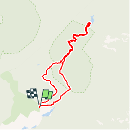
Trail Walking of 8.3 km to be discovered at Provence-Alpes-Côte d'Azur, Var, Saint-Raphaël. This trail is proposed by alpha-pyxidis.
Description
Une belle randonnée dépaysante dans le massif de l'Estérel : on se croirait en Australie...
Détails et photos : http://www.alpha-pyxidis.com/provence/le-lac-de-l-ecureuil
Positioning
Country:
France
Region :
Provence-Alpes-Côte d'Azur
Department/Province :
Var
Municipality :
Saint-Raphaël
Location:
Unknown
Start:(Dec)
Start:(UTM)
327587 ; 4813727 (32T) N.
Comments
Trails nearby
![Trail Walking Saint-Raphaël - Sommet du Bonnet de Capelan - Photo](https://media.geolcdn.com/t/375/260/05863c9a-49da-4f41-9bfb-5d37c8a1781d.jpg&format=jpg&maxdim=2)
![Walking Walking](https://static1.geolcdn.com/sitytour/trail-icons/101.png)
Sommet du Bonnet de Capelan
Walking
Very difficult
(1)
Saint-Raphaël,
Provence-Alpes-Côte d'Azur,
Var,
France
![](/images/other/stat-length.png)
17.7 km | 25 km-effort
4h 40min
![](https://static1.geolcdn.com/siteimages/upload/files/16400158638029165_repeat_loop_refresh_sync_direction_icon.png)
Yes
![Trail Walking Saint-Raphaël - Massif d'ésterel-grande boucle pic cap roux - Photo](https://media.geolcdn.com/t/375/260/75f5531d-898d-4f51-8086-6652c6aad722.jpg&format=jpg&maxdim=2)
![Walking Walking](https://static1.geolcdn.com/sitytour/trail-icons/101.png)
Massif d'ésterel-grande boucle pic cap roux
Walking
Medium
(2)
Saint-Raphaël,
Provence-Alpes-Côte d'Azur,
Var,
France
![](/images/other/stat-length.png)
10.4 km | 17.5 km-effort
2h 58min
![](https://static1.geolcdn.com/siteimages/upload/files/16400158638029165_repeat_loop_refresh_sync_direction_icon.png)
Yes
![Trail Walking Saint-Raphaël - Les lacs par les rochers du Caneiret - Photo](https://media.geolcdn.com/t/375/260/cddead80-47f3-4091-93b3-1398b473dc08.jpg&format=jpg&maxdim=2)
![Walking Walking](https://static1.geolcdn.com/sitytour/trail-icons/101.png)
Les lacs par les rochers du Caneiret
Walking
Medium
(1)
Saint-Raphaël,
Provence-Alpes-Côte d'Azur,
Var,
France
![](/images/other/stat-length.png)
20 km | 29 km-effort
5h 7min
![](https://static1.geolcdn.com/siteimages/upload/files/16400158638029165_repeat_loop_refresh_sync_direction_icon.png)
Yes
![Trail Walking Saint-Raphaël - le Dramont - Photo](https://media.geolcdn.com/t/375/260/83d1f287-d047-452c-844a-302c6891c476.jpg&format=jpg&maxdim=2)
![Walking Walking](https://static1.geolcdn.com/sitytour/trail-icons/101.png)
le Dramont
Walking
Medium
(2)
Saint-Raphaël,
Provence-Alpes-Côte d'Azur,
Var,
France
![](/images/other/stat-length.png)
5.7 km | 8.3 km-effort
2h 32min
![](https://static1.geolcdn.com/siteimages/upload/files/16400158638029165_repeat_loop_refresh_sync_direction_icon.png)
Yes
![Trail Walking Saint-Raphaël - Le tour du Pic du Cap Roux - St Raphaël (Agay) - Photo](https://media.geolcdn.com/t/375/260/ext.jpg?maxdim=2&url=https%3A%2F%2Fservices.sitytrail.com%2FGeolivesWS%2FDownloadMedia.ashx%3FTrailID%3D317929%26Media%3D17353_6.jpg)
![Walking Walking](https://static1.geolcdn.com/sitytour/trail-icons/101.png)
Le tour du Pic du Cap Roux - St Raphaël (Agay)
Walking
Medium
(2)
Saint-Raphaël,
Provence-Alpes-Côte d'Azur,
Var,
France
![](/images/other/stat-length.png)
7.2 km | 12.8 km-effort
2h 0min
![](https://static1.geolcdn.com/siteimages/upload/files/16400158638029165_repeat_loop_refresh_sync_direction_icon.png)
Yes
![Trail Walking Saint-Raphaël - Pic du Cap Roux - Photo](https://media.geolcdn.com/t/375/260/ext.jpg?maxdim=2&url=https%3A%2F%2Fservices.sitytrail.com%2FGeolivesWS%2FDownloadMedia.ashx%3FTrailID%3D230669%26Media%3Dfix__20131103111411.jpg)
![Walking Walking](https://static1.geolcdn.com/sitytour/trail-icons/101.png)
Pic du Cap Roux
Walking
Very easy
(4)
Saint-Raphaël,
Provence-Alpes-Côte d'Azur,
Var,
France
![](/images/other/stat-length.png)
4.1 km | 7.8 km-effort
1h 17min
![](https://static1.geolcdn.com/siteimages/upload/files/16400158638029165_repeat_loop_refresh_sync_direction_icon.png)
Yes
![Trail Walking Saint-Raphaël - SityTrail - ND - Aiguille - Photo](https://media.geolcdn.com/t/375/260/ext.jpg?maxdim=2&url=https%3A%2F%2Fstatic1.geolcdn.com%2Fsiteimages%2Fupload%2Ffiles%2F1553511878bg_sport_marche.png)
![Walking Walking](https://static1.geolcdn.com/sitytour/trail-icons/101.png)
SityTrail - ND - Aiguille
Walking
Very difficult
(1)
Saint-Raphaël,
Provence-Alpes-Côte d'Azur,
Var,
France
![](/images/other/stat-length.png)
18.1 km | 29 km-effort
6h 40min
![](https://static1.geolcdn.com/siteimages/upload/files/16400158638029165_repeat_loop_refresh_sync_direction_icon.png)
Yes
![Trail Walking Saint-Raphaël - Agay - Sainte-Barbe - Étang des Nénuphares - Photo](https://media.geolcdn.com/t/375/260/dfb7073a-02d4-4811-84ba-99dc2878a0d2.jpg&format=jpg&maxdim=2)
![Walking Walking](https://static1.geolcdn.com/sitytour/trail-icons/101.png)
Agay - Sainte-Barbe - Étang des Nénuphares
Walking
Easy
(2)
Saint-Raphaël,
Provence-Alpes-Côte d'Azur,
Var,
France
![](/images/other/stat-length.png)
5 km | 6.2 km-effort
2h 8min
![](https://static1.geolcdn.com/siteimages/upload/files/16400158638029165_repeat_loop_refresh_sync_direction_icon.png)
Yes
![Trail Walking Saint-Raphaël - Tour du Pic de l'Ours - Le Trayas - Photo](https://media.geolcdn.com/t/375/260/ext.jpg?maxdim=2&url=https%3A%2F%2Fservices.sitytrail.com%2FGeolivesWS%2FDownloadMedia.ashx%3FTrailID%3D191486%26Media%3D15078_2.jpg)
![Walking Walking](https://static1.geolcdn.com/sitytour/trail-icons/101.png)
Tour du Pic de l'Ours - Le Trayas
Walking
Medium
(1)
Saint-Raphaël,
Provence-Alpes-Côte d'Azur,
Var,
France
![](/images/other/stat-length.png)
9.5 km | 16 km-effort
3h 0min
![](https://static1.geolcdn.com/siteimages/upload/files/16400158638029165_repeat_loop_refresh_sync_direction_icon.png)
Yes