![](/images/other/stat-length.png)
![Trail Walking La Chapelle-sur-Erdre - Gesvres - Photo](https://media.geolcdn.com/t/1900/400/ext.pjpeg?maxdim=2&url=https%3A%2F%2Fstatic1.geolcdn.com%2Fsiteimages%2Fupload%2Ffiles%2F1553511878bg_sport_marche.png)
Gesvres
Mitche44
User
![Length](/images/other/stat-length.png)
![Max alt](https://static1.geolcdn.com/siteimages/upload/files/1508320355ic_sort_altitude_max_24dp.png)
![Uphill gradient](https://static1.geolcdn.com/siteimages/upload/files/1508320355ic_sort_den_pos_24dp.png)
![Km-Effort](/images/other/stat-length.png)
![Min alt](https://static1.geolcdn.com/siteimages/upload/files/1508320355ic_sort_altitude_min_24dp.png)
![Downhill gradient](https://static1.geolcdn.com/siteimages/upload/files/1508320355ic_sort_den_neg_24dp.png)
![Boucle](https://static1.geolcdn.com/siteimages/upload/files/16400158638029165_repeat_loop_refresh_sync_direction_icon.png)
![Walking](https://static1.geolcdn.com/sitytour/trail-icons/101.png)
2h10
Difficulty : Medium
![Scan this QR Code to open this trail in the SityTrail application](https://capi.geolives.com/qq0zvz2zws4bq2lad0pu/sitytour/trails/160700/qr.png?size=200)
FREE GPS app for hiking
About
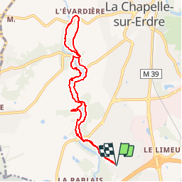
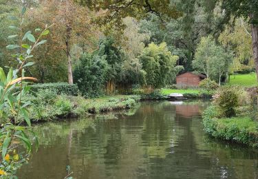
Trail Walking of 8.3 km to be discovered at Pays de la Loire, Loire-Atlantique, La Chapelle-sur-Erdre. This trail is proposed by Mitche44.
Description
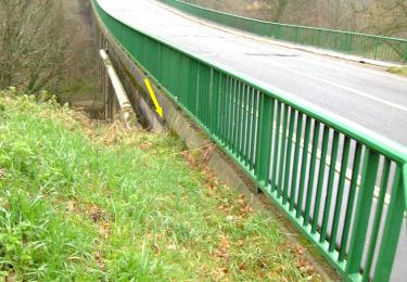
Départ randonnée : La chapelle sur Erdre (Loire-Atlantique 44) La rivière Gesvres à la Chapelle sur Erdre m'était inconnue jusqu'alors, et la ballade en boucle que je propose vaut le détours par temps sec, avec même une (toute) petite descente en rappel pour le fun .Attention : Si vous n'êtes pas équipé de cordes pour le rappel, il est possible de l'éviter en prenant un peu plus haut.Bonne randonnée
Positioning
Comments
Trails nearby
![Trail On foot La Chapelle-sur-Erdre - grand circuit Erdre/Gesvres - Photo](https://media.geolcdn.com/t/375/260/36b563d8-5e42-407f-af20-6207f8d9317f.jpeg&format=jpg&maxdim=2)
![On foot On foot](https://static1.geolcdn.com/sitytour/trail-icons/100.png)
On foot
![](/images/other/stat-length.png)
![](https://static1.geolcdn.com/siteimages/upload/files/16400158638029165_repeat_loop_refresh_sync_direction_icon.png)
![Trail Walking Carquefou - Carquefou les hauts - Photo](https://media.geolcdn.com/t/375/260/ext.jpg?maxdim=2&url=https%3A%2F%2Fstatic1.geolcdn.com%2Fsiteimages%2Fupload%2Ffiles%2F1553511878bg_sport_marche.png)
![Walking Walking](https://static1.geolcdn.com/sitytour/trail-icons/101.png)
Walking
![](/images/other/stat-length.png)
![](https://static1.geolcdn.com/siteimages/upload/files/16400158638029165_repeat_loop_refresh_sync_direction_icon.png)
![Trail On foot La Chapelle-sur-Erdre - La Source, Le Rupt, l'ancienne voie de chemin de fer - Photo](https://media.geolcdn.com/t/375/260/dd46a926-2019-47c5-9f72-3994a23fb768.jpeg&format=jpg&maxdim=2)
![On foot On foot](https://static1.geolcdn.com/sitytour/trail-icons/100.png)
On foot
![](/images/other/stat-length.png)
![](https://static1.geolcdn.com/siteimages/upload/files/16400158638029165_repeat_loop_refresh_sync_direction_icon.png)
![Trail On foot Carquefou - Les Bords de l'Erdre - Photo](https://media.geolcdn.com/t/375/260/c7417e76-e2f6-40cc-bd1f-087623dde044.jpeg&format=jpg&maxdim=2)
![On foot On foot](https://static1.geolcdn.com/sitytour/trail-icons/100.png)
On foot
![](/images/other/stat-length.png)
![](https://static1.geolcdn.com/siteimages/upload/files/16400158638029165_repeat_loop_refresh_sync_direction_icon.png)
![Trail Mountain bike La Chapelle-sur-Erdre - gr3 et vallée du cens - Photo](https://media.geolcdn.com/t/375/260/ext.jpg?maxdim=2&url=https%3A%2F%2Fstatic1.geolcdn.com%2Fsiteimages%2Fupload%2Ffiles%2F1524743154velo.jpg)
![Mountain bike Mountain bike](https://static1.geolcdn.com/sitytour/trail-icons/202.png)
Mountain bike
![](/images/other/stat-length.png)
![](https://static1.geolcdn.com/siteimages/upload/files/16400158638029165_repeat_loop_refresh_sync_direction_icon.png)
![Trail Hybrid bike Nantes - etape n°1 l'hippodrome université Nantes à Plessis pas Brunet - Photo](https://media.geolcdn.com/t/375/260/f11b735e-088e-4766-b0fc-11001b7156c1.jpg&format=jpg&maxdim=2)
![Hybrid bike Hybrid bike](https://static1.geolcdn.com/sitytour/trail-icons/203.png)
Hybrid bike
![](/images/other/stat-length.png)
![](https://static1.geolcdn.com/siteimages/upload/files/16400158638029165_repeat_loop_refresh_sync_direction_icon.png)
![Trail Walking La Chapelle-sur-Erdre - La Chapelle Erdre Gascherie - Photo](https://media.geolcdn.com/t/375/260/6320ae57-0364-4b55-88d0-a7ec8f53670f.jpg&format=jpg&maxdim=2)
![Walking Walking](https://static1.geolcdn.com/sitytour/trail-icons/101.png)
Walking
![](/images/other/stat-length.png)
![](https://static1.geolcdn.com/siteimages/upload/files/16400158638029165_repeat_loop_refresh_sync_direction_icon.png)
![Trail Walking La Chapelle-sur-Erdre - Nantes - Photo](https://media.geolcdn.com/t/375/260/c71f4b0c-4767-4bda-b5dd-03deb4e6ff77.jpg&format=jpg&maxdim=2)
![Walking Walking](https://static1.geolcdn.com/sitytour/trail-icons/101.png)
Walking
![](/images/other/stat-length.png)
![](https://static1.geolcdn.com/siteimages/upload/files/16400158638029165_repeat_loop_refresh_sync_direction_icon.png)
![Trail Walking La Chapelle-sur-Erdre - Grand tour autour de Sucé-sur-Erdre - Photo](https://media.geolcdn.com/t/375/260/ae50aa92-db3b-4719-aaa5-76faec7582e7.jpg&format=jpg&maxdim=2)
![Walking Walking](https://static1.geolcdn.com/sitytour/trail-icons/101.png)
Walking
![](/images/other/stat-length.png)
![](https://static1.geolcdn.com/siteimages/upload/files/16400158638029165_repeat_loop_refresh_sync_direction_icon.png)