Trail Walking Théminettes - Theminettes dolmen - Photo

Theminettes dolmen

 gannet1
gannet1

User

© OpenStreetMap contributors
Length
Length
9.8 km
Max alt
Max alt
360 m
Uphill gradient
Uphill gradient
121 m
Km-Effort
Km-Effort  
11.4 km
Min alt
Min alt
331 m
Downhill gradient
Downhill gradient
121 m
Boucle
Boucle
Yes
Creation date :
2014-12-10 00:00:00.0
Updated on :
2014-12-10 00:00:00.0

(0 Reviews)

Walking
Walking
2h29
Difficulty : Very easy

Scan this QR Code to open this trail in the SityTrail application

FREE GPS app for hiking

Logo SityTrail SityTrail

IGN / Geographical institutes

Download SityTrail from the App Store Download SityTrail from Google Play

Logo SityTrail SityTrail World

The world is yours!

Download SityTrail from the App Store Download SityTrail from Google Play Download SityTrail on Huawei AppGallery

About

Trail Walking of 9.8 km to be discovered at Occitania, Lot, Théminettes. This trail is proposed by gannet1.

Description

Passage près d''un dolmen un peu hors parcours. Causse et campagne plus verdoyante.
Testé par le groupe de marche SELM

Elevation profile

Photos

Points of interest

Point of interest Saint-Simon - dolmen - Photo
gannet1
SAINT-SIMON 

Positioning

Country:
France
Region :
Occitania
Department/Province :
Lot
Municipality :
Théminettes
Location:
Unknown
Start:(UTM)
409227 ; 4951909 (31T) N.

Trails nearby

Trail Walking Sonac - Theminettes Les Causses - Photo
Walking
gannet1

Walking

Easy
(4)
Sonac, Occitania, Lot, France
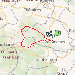
14.6 km | 17.3 km-effort
3h 46min
No
Trail Walking Théminettes - Theminette  - Photo
Walking
Gegetop

Walking

Easy
Théminettes, Occitania, Lot, France
10.7 km | 12.4 km-effort
2h 36min
Yes
Trail Walking Thémines - Themines Rueyres 11km5-12030072 - Photo
Walking
houbart

Walking

Difficult
Thémines, Occitania, Lot, France
10.8 km | 14 km-effort
3h 10min
Yes
Trail Walking Thémines - themine - Photo
Walking
thomas.o.vert

Walking

Easy
Thémines, Occitania, Lot, France
10.6 km | 13.2 km-effort
2h 47min
Yes
Trail Walking Rudelle - rudelle - Photo
Walking
thomas.o.vert

Walking

Easy
Rudelle, Occitania, Lot, France
9.3 km | 11.6 km-effort
2h 17min
Yes
Trail Walking Théminettes - theminettes - Photo
Walking
thomas.o.vert

Walking

Easy
Théminettes, Occitania, Lot, France
11.9 km | 13.9 km-effort
2h 47min
Yes
Trail Walking Rueyres - rueyes  rudelle - Photo
Walking
gcournac

Walking

Difficult
Rueyres, Occitania, Lot, France
14.4 km | 18.1 km-effort
3h 32min
No
Trail Walking Assier - assier rs  - Photo
Walking
gcournac

Walking

Easy
Assier, Occitania, Lot, France
5 km | 5.8 km-effort
1h 30min
No
Trail Mountain bike Saint-Simon - reilhac gramat  - Photo
Mountain bike
lafé

Mountain bike

Easy
Saint-Simon, Occitania, Lot, France
51 km | 58 km-effort
3h 53min
Yes


Close
My subscriptions