Trail Walking Boutencourt - Boutencourt - Le Vaumain - Photo

Boutencourt - Le Vaumain

 marcel.F
marcel.F

User

© OpenStreetMap contributors
Length
Length
8.7 km
Max alt
Max alt
159 m
Uphill gradient
Uphill gradient
136 m
Km-Effort
Km-Effort  
10.5 km
Min alt
Min alt
88 m
Downhill gradient
Downhill gradient
136 m
Boucle
Boucle
Yes
Creation date :
2015-11-24 00:00:00.0
Updated on :
2019-04-20 08:51:01.548

(1 Reviews)

Walking
Walking
2h16
Difficulty : Easy

Scan this QR Code to open this trail in the SityTrail application

FREE GPS app for hiking

Logo SityTrail SityTrail

IGN / Geographical institutes

Download SityTrail from the App Store Download SityTrail from Google Play

Logo SityTrail SityTrail World

The world is yours!

Download SityTrail from the App Store Download SityTrail from Google Play Download SityTrail on Huawei AppGallery

About

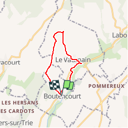
Trail Walking of 8.7 km to be discovered at Hauts-de-France, Oise, Boutencourt. This trail is proposed by marcel.F.

Description

Boucle au départ mairie de Boutencourt
Etang du Moulin de la forge = domaine privé > tél M ou Mme Bourbier 03 44 49 26 26 deux semaines avant

Elevation profile

Positioning

Country:
France
Region :
Hauts-de-France
Department/Province :
Oise
Municipality :
Boutencourt
Location:
Unknown
Start:(UTM)
417073 ; 5463646 (31U) N.

Comments

Please log in to post a review or rate the element


cc


Trails nearby

Trail Walking Flavacourt - Flavacourt - Vexin Français - Photo
Walking
tracegps

Walking

Medium
(1)
Flavacourt, Hauts-de-France, Oise, France
28 km | 33 km-effort
5h 30min
Yes
Trail Walking Le Vaumain - Le Moulin de la forge à Boutencourt, les Maisonnettes, Le Vaumain - Photo
Walking
Marie-Claire-mcp

Walking

Medium
(1)
Le Vaumain, Hauts-de-France, Oise, France
8.8 km | 10.4 km-effort
2h 22min
Yes
Trail Walking Trie-Château - Trie Château - La vallée de l'Aunette - Photo
Walking
marcel.F

Walking

Difficult
(1)
Trie-Château, Hauts-de-France, Oise, France
11.8 km | 13.7 km-effort
3h 0min
Yes
Trail Walking Flavacourt - Flavacourt - le grand chêne et dolmen - Photo
Walking
marcel.F

Walking

Easy
(1)
Flavacourt, Hauts-de-France, Oise, France
9.7 km | 12.1 km-effort
2h 38min
Yes
Trail Walking Trie-Château - Mégalithes Trie Château  - Photo
Walking
runarlejou

Walking

Easy
Trie-Château, Hauts-de-France, Oise, France
10.6 km | 13.7 km-effort
2h 26min
Yes
Trail Walking Flavacourt - la forêt de Thelle  - Photo
Walking
serge.guerroult

Walking

Difficult
Flavacourt, Hauts-de-France, Oise, France
14.7 km | 18.2 km-effort
2h 27min
Yes
Trail Walking Flavacourt - LINCOURT LE VAUMAIN V2 - Photo
Walking
marie23

Walking

Difficult
Flavacourt, Hauts-de-France, Oise, France
12.4 km | 14.4 km-effort
3h 10min
Yes
Trail Walking Le Vaumain - Le Vaumain - Le moulin Vieux var2 - Photo
Walking
marcel.F

Walking

Medium
Le Vaumain, Hauts-de-France, Oise, France
11.4 km | 13.7 km-effort
2h 10min
Yes
Trail Walking Flavacourt - LINCOURT LE VAUMAIN  - Photo
Walking
marie23

Walking

Difficult
Flavacourt, Hauts-de-France, Oise, France
12.9 km | 14.8 km-effort
3h 10min
Yes


Close
My subscriptions