Trail Other activity Fellering - Drumont - Photo
 fab68470
fab68470

User

© OpenStreetMap contributors
Length
Length
11.2 km
Max alt
Max alt
1188 m
Uphill gradient
Uphill gradient
586 m
Km-Effort
Km-Effort  
19 km
Min alt
Min alt
690 m
Downhill gradient
Downhill gradient
589 m
Boucle
Boucle
Yes
Creation date :
2014-12-10 00:00:00.0
Updated on :
2014-12-10 00:00:00.0

(0 Reviews)

Other activity
Other activity
3h00
Difficulty : Unknown

Scan this QR Code to open this trail in the SityTrail application

FREE GPS app for hiking

Logo SityTrail SityTrail

IGN / Geographical institutes

Download SityTrail from the App Store Download SityTrail from Google Play

Logo SityTrail SityTrail World

The world is yours!

Download SityTrail from the App Store Download SityTrail from Google Play Download SityTrail on Huawei AppGallery

About

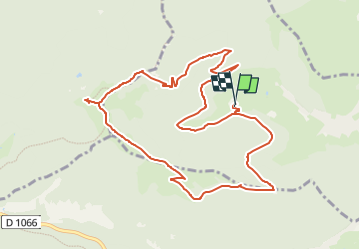
Trail Other activity of 11.2 km to be discovered at Grand Est, Haut-Rhin, Fellering. This trail is proposed by fab68470.

Description

Depuis le rammersbach à Fellering, Hasenkopf 4.8KM  542m
Drumont 5.8km  583m
Gustiberg 7.8km -373m
Rammersbach 11.2Km-647

Elevation profile

Positioning

Country:
France
Region :
Grand Est
Department/Province :
Haut-Rhin
Municipality :
Fellering
Location:
Unknown
Start:(UTM)
346022 ; 5307430 (32T) N.

Trails nearby

Trail Walking Bussang - Col de Bussang - Rouge Gazon - Séchenat - Photo
Walking
VacheKiri67

Walking

Difficult
(1)
Bussang, Grand Est, Vosges, France
15 km | 24 km-effort
6h 0min
No
Trail Walking Fellering - Felsach _chapelle ST Nicolas_frenz - Photo
Walking
Le grand Claude

Walking

Difficult
(3)
Fellering, Grand Est, Haut-Rhin, France
9.6 km | 16.5 km-effort
3h 45min
Yes
Trail Walking Oderen - 6146369-Chapelle St Nicolas 2 - Photo
Walking

Walking

Medium
(1)
Oderen, Grand Est, Haut-Rhin, France
10.9 km | 17.9 km-effort
3h 41min
Yes
Trail Walking Kruth - barrage de Wildenstein et Grand Ventron - Photo
Walking
egodard

Walking

Medium
(1)
Kruth, Grand Est, Haut-Rhin, France
13.7 km | 24 km-effort
4h 40min
Yes
Trail Walking Oderen - TREK ALSACIEN (boucle, la meute) - Photo
Walking
Godasses et Grosses Pattes

Walking

Difficult
Oderen, Grand Est, Haut-Rhin, France
14.3 km | 23 km-effort
4h 30min
Yes
Trail Walking Oderen - Oderen Bergenbach Langenbach - Photo
Walking
geishouse

Walking

Medium
Oderen, Grand Est, Haut-Rhin, France
7.1 km | 11.6 km-effort
3h 40min
No
Trail Walking Mollau - Le rossberg - Photo
Walking
margotte

Walking

Medium
Mollau, Grand Est, Haut-Rhin, France
14.9 km | 25 km-effort
7h 41min
Yes
Trail Walking Oderen - TREK ALSACIEN (1ère étape) - Photo
Walking
Godasses et Grosses Pattes

Walking

Medium
Oderen, Grand Est, Haut-Rhin, France
9.2 km | 18.1 km-effort
4h 0min
No
Trail Walking Ventron - Rando des Marcheurs..22/02/2024... - Photo
Walking
boubou68

Walking

Very difficult
Ventron, Grand Est, Vosges, France
19.5 km | 31 km-effort
5h 4min
Yes


Close
My subscriptions