


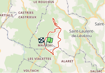

8.4 km | 11.4 km-effort


User


FREE GPS app for hiking
 SityTrail
IGN / Geographical institutes
SityTrail World
The world is yours!
Trail Walking of 11.1 km to be discovered at Occitania, Aveyron, Saint-Laurent-de-Lévézou. This trail is proposed by colber.
Rando sans contrainte. Facile


Running

Walking
Walking
Walking


Trail
Horseback riding