Trail Walking Mérindol - Mérandol Combe de l'Euse - Photo
 phidge
phidge

User

© OpenStreetMap contributors
Length
Length
16.9 km
Max alt
Max alt
580 m
Uphill gradient
Uphill gradient
616 m
Km-Effort
Km-Effort  
25 km
Min alt
Min alt
152 m
Downhill gradient
Downhill gradient
618 m
Boucle
Boucle
Yes
Creation date :
2019-01-20 16:37:38.839
Updated on :
2019-01-20 16:37:38.891

(0 Reviews)

Walking
Walking
6h46
Difficulty : Medium

Scan this QR Code to open this trail in the SityTrail application

FREE GPS app for hiking

Logo SityTrail SityTrail

IGN / Geographical institutes

Download SityTrail from the App Store Download SityTrail from Google Play

Logo SityTrail SityTrail World

The world is yours!

Download SityTrail from the App Store Download SityTrail from Google Play Download SityTrail on Huawei AppGallery

About

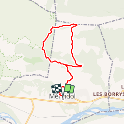
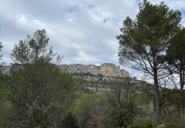
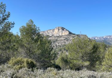
Trail Walking of 16.9 km to be discovered at Provence-Alpes-Côte d'Azur, Vaucluse, Mérindol. This trail is proposed by phidge.

Description

Rando de Richard

Elevation profile

Photos

Points of interest

Positioning

Country:
France
Region :
Provence-Alpes-Côte d'Azur
Department/Province :
Vaucluse
Municipality :
Mérindol
Location:
Unknown
Start:(UTM)
677330 ; 4846916 (31T) N.

Comments

Please log in to post a review or rate the element


Je découvre le logiciel. les cartes sont claires, je pense qu' avec de la pratique se sera un bon outil


Trails nearby

Trail Walking Mallemort - SityTrail - GRvP - De Mallemort à Mérindol - Photo
Walking
GUIDE
MicDul

Walking

Easy
Mallemort, Provence-Alpes-Côte d'Azur, Bouches-du-Rhône, France
5.3 km | 6.1 km-effort
1h 30min
No
Trail Walking Puget - SityTrail - Les borries  - Photo
Walking
GUIDE
MicDul

Walking

Medium
Puget, Provence-Alpes-Côte d'Azur, Vaucluse, France
7.5 km | 11 km-effort
3h 0min
Yes
Trail Walking Charleval - CHAINE DES COTES CHARLEVAL - Photo
Walking
ARPF

Walking

Medium
(1)
Charleval, Provence-Alpes-Côte d'Azur, Bouches-du-Rhône, France
12.6 km | 17.9 km-effort
3h 46min
Yes
Trail Walking Charleval - Gambadous - Charleval - Photo
Walking
Taricot

Walking

Easy
(2)
Charleval, Provence-Alpes-Côte d'Azur, Bouches-du-Rhône, France
7.5 km | 10.5 km-effort
2h 13min
Yes
Trail Walking Mérindol - Mérindol - Photo
Walking
titoune51

Walking

Medium
(1)
Mérindol, Provence-Alpes-Côte d'Azur, Vaucluse, France
7.2 km | 10.2 km-effort
2h 37min
Yes
Trail Walking Cheval-Blanc - Régalon boucle standard - Photo
Walking
hervef13300

Walking

Medium
(1)
Cheval-Blanc, Provence-Alpes-Côte d'Azur, Vaucluse, France
9 km | 13.3 km-effort
3h 0min
Yes
Trail Walking Cheval-Blanc - 2024-11-03 Le Régalon - Photo
Walking
GUIDE
Kargil

Walking

Difficult
Cheval-Blanc, Provence-Alpes-Côte d'Azur, Vaucluse, France
12.5 km | 17.7 km-effort
4h 0min
Yes
Trail Walking Mérindol - PF-Mérindol - Autour de la Roque Malière - Arboretum - Vieux Mérindol - FV - 28.03.2024 - Photo
Walking
GUIDE
MicDul

Walking

Easy
Mérindol, Provence-Alpes-Côte d'Azur, Vaucluse, France
7.8 km | 11 km-effort
2h 30min
Yes
Trail Walking Mérindol - PF-Mérindol - Dessus de Mérindol par les Chemins de l'Apied et des Bouigues - Vallon des Porcs - CP - Photo
Walking
GUIDE
MicDul

Walking

Medium
Mérindol, Provence-Alpes-Côte d'Azur, Vaucluse, France
8.9 km | 12.8 km-effort
2h 54min
Yes


Close
My subscriptions