Trail Other activity Marthod - Sentier de Combe Céros/ sentier botanique - Photo

Sentier de Combe Céros/ sentier botanique

© OpenStreetMap contributors
Length
Length
7.5 km
Max alt
Max alt
1396 m
Uphill gradient
Uphill gradient
128 m
Km-Effort
Km-Effort  
12.3 km
Min alt
Min alt
429 m
Downhill gradient
Downhill gradient
1071 m
Boucle
Boucle
No
Creation date :
2014-12-10 00:00:00.0
Updated on :
2014-12-10 00:00:00.0

(0 Reviews)

Other activity
Other activity
--
Difficulty : Unknown

Scan this QR Code to open this trail in the SityTrail application

FREE GPS app for hiking

Logo SityTrail SityTrail

IGN / Geographical institutes

Download SityTrail from the App Store Download SityTrail from Google Play

Logo SityTrail SityTrail World

The world is yours!

Download SityTrail from the App Store Download SityTrail from Google Play Download SityTrail on Huawei AppGallery

About

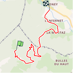
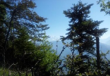
Trail Other activity of 7.5 km to be discovered at Auvergne-Rhône-Alpes, Savoy, Marthod. This trail is proposed by bebe73200.

Description

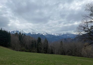
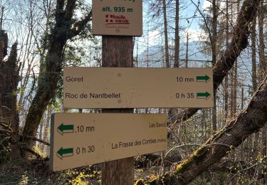
Nom : Sentier de Combe Céros/ sentier botanique
Département : Savoie
Massif : Bauges
Type : Sentier large (>50cm)
Longueur : 8000 m.
Denivelé négatif : 1190 m.
Denivelé positif : 100 m.
Difficulté (descente) : T3
Montée : Inroulable
Exposition : E1
Roulabilité : Quelques obstacles
Généralement parcouru : à la descente uniquement
Interêt : 6/10 (1 vote)
Point de départ :
Latitude/Longitude : 45.7426 N / 6.36979 E
Coordonnées GPS : 32T 295396 5068814
Remarques (Variantes, type de sol, fréquentation, ...) :
Du Col de l'Alpettaz, piste sur raide sur trois lacets, puis single étroit jusqu'à la cote 1000. Remontée de 50m (sentier peu marqué)jusqu'à la Mouchette, piste jusqu'au carrefour du Morand (900m) puis à gauche( non marqué sur IGN) piste puis single direction la Montaz, Outrechaise

Elevation profile

Positioning

Country:
France
Region :
Auvergne-Rhône-Alpes
Department/Province :
Savoy
Municipality :
Marthod
Location:
Unknown
Start:(UTM)
295388 ; 5068818 (32T) N.

Trails nearby

Trail Walking Marthod - Dent de Cons en boucle depuis Raffort - Photo
Walking
GUIDE
nadd73

Walking

Medium
Marthod, Auvergne-Rhône-Alpes, Savoy, France
8.5 km | 23 km-effort
4h 21min
No
Trail Walking Saint-Ferréol - Crêt des Mouches 08-2019 - Photo
Walking
GUIDE
Kargil

Walking

Difficult
Saint-Ferréol, Auvergne-Rhône-Alpes, Upper Savoy, France
12.3 km | 31 km-effort
6h 48min
Yes
Trail Walking Marthod - Santier botanique - Photo
Walking
biollay

Walking

Difficult
Marthod, Auvergne-Rhône-Alpes, Savoy, France
7.3 km | 12 km-effort
2h 49min
Yes
Trail Walking Marthod - Le fort de la batterie - Photo
Walking
ochamley

Walking

Very easy
Marthod, Auvergne-Rhône-Alpes, Savoy, France
3.2 km | 6.9 km-effort
1h 2min
Yes
Trail Road bike Val de Chaise - 38 vélo autour lac annecy 04.08.22 - Photo
Road bike
GUIDE
randodyssée

Road bike

Easy
Val de Chaise, Auvergne-Rhône-Alpes, Upper Savoy, France
63 km | 71 km-effort
5h 8min
Yes
Trail Walking Saint-Ferréol - Presque le château de Montaigu - Photo
Walking
pacal08

Walking

Difficult
Saint-Ferréol, Auvergne-Rhône-Alpes, Upper Savoy, France
10 km | 16.4 km-effort
2h 17min
Yes
Trail Walking Saint-Ferréol - La côte de Marlens - Photo
Walking
pacal08

Walking

Medium
Saint-Ferréol, Auvergne-Rhône-Alpes, Upper Savoy, France
13.8 km | 21 km-effort
2h 50min
Yes
Trail Walking Ugine - chateau - Photo
Walking
Bugeat

Walking

Medium
Ugine, Auvergne-Rhône-Alpes, Savoy, France
15.8 km | 29 km-effort
4h 11min
Yes
Trail Walking Val de Chaise - nantbellet 2 - Photo
Walking
COMAN

Walking

Very easy
Val de Chaise, Auvergne-Rhône-Alpes, Upper Savoy, France
7.5 km | 10.2 km-effort
2h 27min
Yes


Close
My subscriptions