Trail Walking Ally - Ally, sur la piste du vent... - Photo

Ally, sur la piste du vent...

© OpenStreetMap contributors
Length
Length
4.9 km
Max alt
Max alt
1066 m
Uphill gradient
Uphill gradient
77 m
Km-Effort
Km-Effort  
6 km
Min alt
Min alt
963 m
Downhill gradient
Downhill gradient
121 m
Boucle
Boucle
No
Creation date :
2014-12-10 00:00:00.0
Updated on :
2014-12-10 00:00:00.0

(0 Reviews)

Walking
Walking
--
Difficulty : Easy

Scan this QR Code to open this trail in the SityTrail application

FREE GPS app for hiking

Logo SityTrail SityTrail

IGN / Geographical institutes

Download SityTrail from the App Store Download SityTrail from Google Play

Logo SityTrail SityTrail World

The world is yours!

Download SityTrail from the App Store Download SityTrail from Google Play Download SityTrail on Huawei AppGallery

About

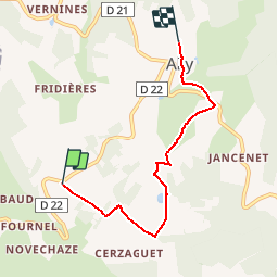
Trail Walking of 4.9 km to be discovered at Auvergne-Rhône-Alpes, Haute-Loire, Ally. This trail is proposed by Chapatann.

Description

Allymersion dehors!Départ de l'éolienne 16, sentiers ruraux. Découverte du paysage. Obj: ressentir, observer, écouter. Approches physique et sensorielle.

Elevation profile

Positioning

Country:
France
Region :
Auvergne-Rhône-Alpes
Department/Province :
Haute-Loire
Municipality :
Ally
Location:
Unknown
Start:(UTM)
523202 ; 4999247 (31T) N.

Trails nearby

Trail Running Ally - CO2 Ally - Photo
Running
Chapatann

Running

Easy
Ally, Auvergne-Rhône-Alpes, Haute-Loire, France
5.2 km | 6.7 km-effort
Unknown
Yes
Trail Walking Ally - CO3 Ally - Photo
Walking
Chapatann

Walking

Easy
Ally, Auvergne-Rhône-Alpes, Haute-Loire, France
5.2 km | 6.8 km-effort
Unknown
Yes
Trail Walking Ally - CO2 Ally - Photo
Walking
Chapatann

Walking

Easy
Ally, Auvergne-Rhône-Alpes, Haute-Loire, France
5.2 km | 6.7 km-effort
Unknown
Yes
Trail Walking Ally - CO1 Ally - Photo
Walking
Chapatann

Walking

Easy
Ally, Auvergne-Rhône-Alpes, Haute-Loire, France
5.3 km | 6.9 km-effort
Unknown
Yes
Trail Walking Chazelles - chemin des ecoliers de Chazelles - Photo
Walking
grostim1234

Walking

Easy
Chazelles, Auvergne-Rhône-Alpes, Cantal, France
6.2 km | 8 km-effort
1h 45min
Yes
Trail Trail La Chapelle-Laurent - mourleyers - Photo
Trail
catherineslater

Trail

Medium
La Chapelle-Laurent, Auvergne-Rhône-Alpes, Cantal, France
7.9 km | 11.1 km-effort
5h 42min
No
Trail Walking La Chapelle-Laurent - La Ch Laurent-Mercoeur - Photo
Walking
catherineslater

Walking

Very easy
La Chapelle-Laurent, Auvergne-Rhône-Alpes, Cantal, France
7.4 km | 9.3 km-effort
2h 8min
No
Trail Running Ally - Ballade découverte mine et moulin a paroles, Ally - Photo
Running
Chapatann

Running

Easy
Ally, Auvergne-Rhône-Alpes, Haute-Loire, France
8.9 km | 12.1 km-effort
Unknown
No
Trail Other activity Ally - CO bourg - Photo
Other activity
Chapatann

Other activity

Very easy
Ally, Auvergne-Rhône-Alpes, Haute-Loire, France
2.1 km | 2.9 km-effort
Unknown
Yes


Close
My subscriptions