Trail Walking Entraunes - Rochegrande  - Photo
© OpenStreetMap contributors
Length
Length
12.5 km
Max alt
Max alt
2763 m
Uphill gradient
Uphill gradient
1039 m
Km-Effort
Km-Effort  
26 km
Min alt
Min alt
1694 m
Downhill gradient
Downhill gradient
1036 m
Boucle
Boucle
Yes
Creation date :
2014-12-10 00:00:00.0
Updated on :
2014-12-10 00:00:00.0

(1 Reviews)

Walking
Walking
5h57
Difficulty : Difficult

Scan this QR Code to open this trail in the SityTrail application

FREE GPS app for hiking

Logo SityTrail SityTrail

IGN / Geographical institutes

Download SityTrail from the App Store Download SityTrail from Google Play

Logo SityTrail SityTrail World

The world is yours!

Download SityTrail from the App Store Download SityTrail from Google Play Download SityTrail on Huawei AppGallery

About

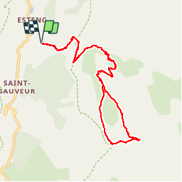
Trail Walking of 12.5 km to be discovered at Provence-Alpes-Côte d'Azur, Maritime Alps, Entraunes. This trail is proposed by PEBREJOSIANE.

Description

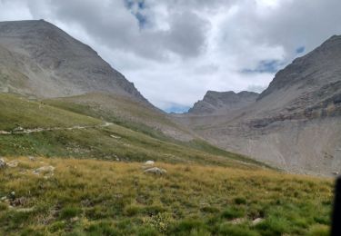
Superbe randonnée alpine, formations gréseuses spectaculaires. Dernière partie dans des eboulis puis petite escalade pour le sommet

Elevation profile

Photos

Positioning

Country:
France
Region :
Provence-Alpes-Côte d'Azur
Department/Province :
Maritime Alps
Municipality :
Entraunes
Location:
Unknown
Start:(UTM)
320681 ; 4899994 (32T) N.

Comments

Please log in to post a review or rate the element


Départ aux Louiqs 1682m et Roche grande 2752mD+ et D- 1100m


Trails nearby

Trail Walking Uvernet-Fours - Mercantour Le Cimet 3020 m - Photo
Walking
pascalspr

Walking

Medium
(2)
Uvernet-Fours, Provence-Alpes-Côte d'Azur, Alpes-de-Haute-Provence, France
20 km | 34 km-effort
5h 49min
Yes
Trail On foot Entraunes - Circuit des Lacs - Photo
On foot
GUIDE+

On foot

Easy
Entraunes, Provence-Alpes-Côte d'Azur, Maritime Alps, France
8.9 km | 14.7 km-effort
3h 21min
Yes
Trail On foot Entraunes - Col de la Boucharde - Photo
On foot
GUIDE+

On foot

Medium
Entraunes, Provence-Alpes-Côte d'Azur, Maritime Alps, France
16.6 km | 29 km-effort
6h 33min
Yes
Trail On foot Entraunes - Tête de la Boulière - Photo
On foot
GUIDE+

On foot

Medium
Entraunes, Provence-Alpes-Côte d'Azur, Maritime Alps, France
16.9 km | 29 km-effort
6h 41min
Yes
Trail Walking Allos - le mont Pelat et le lac du trou de l'aigle - Photo
Walking
GUIDE
amiral13

Walking

Medium
Allos, Provence-Alpes-Côte d'Azur, Alpes-de-Haute-Provence, France
14.4 km | 27 km-effort
7h 19min
Yes
Trail On foot Uvernet-Fours - Circuit des lacs, 04-09-2024 - Photo
On foot
Christiancordin

On foot

Medium
Uvernet-Fours, Provence-Alpes-Côte d'Azur, Alpes-de-Haute-Provence, France
9.1 km | 15.2 km-effort
3h 27min
Yes
Trail Walking Entraunes - Cirque de la Sanguinière, 05-09-2024 - Photo
Walking
Christiancordin

Walking

Medium
Entraunes, Provence-Alpes-Côte d'Azur, Maritime Alps, France
12.2 km | 20 km-effort
3h 53min
Yes
Trail Walking Allos - Pk du Laus - Lacs de la Petite Cayolle, des Garrets et Allos - Photo
Walking
LtZIP

Walking

Medium
Allos, Provence-Alpes-Côte d'Azur, Alpes-de-Haute-Provence, France
13.9 km | 22 km-effort
4h 7min
Yes
Trail Walking Allos - ALLOS. LAC D ALLOS. COL DE LACAYOLE .O - Photo
Walking
RobinMicheline

Walking

Medium
Allos, Provence-Alpes-Côte d'Azur, Alpes-de-Haute-Provence, France
12.1 km | 19.7 km-effort
3h 39min
No


Close
My subscriptions