


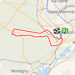


17.3 km | 20 km-effort


User


FREE GPS app for hiking
 SityTrail
IGN / Geographical institutes
SityTrail World
The world is yours!
Trail Walking of 12 km to be discovered at Ile-de-France, Seine-et-Marne, Moret-Loing-et-Orvanne. This trail is proposed by randodan.
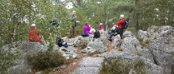
Mercredi matin . Wouah ! Ce matin, c'est Mireille qui conduit . Elle nous mène direct au Rocher des Princes . Au retour, petite pause aux pieds de Clotilde .
9 participants .


Walking

Walking

Walking

Walking

Walking

On foot

On foot

On foot

On foot