![](/images/other/stat-length.png)
![Trail Walking Wisches - La vallée du Netzenbach - Photo](https://media.geolcdn.com/t/1900/400/ext.pjpeg?maxdim=2&url=https%3A%2F%2Fservices.sitytrail.com%2FGeolivesWS%2FDownloadMedia.ashx%3FTrailID%3D156043%26Media%3D20120930133908.jpeg)
La vallée du Netzenbach
VacheKiri67
User
![Length](/images/other/stat-length.png)
![Max alt](https://static1.geolcdn.com/siteimages/upload/files/1508320355ic_sort_altitude_max_24dp.png)
![Uphill gradient](https://static1.geolcdn.com/siteimages/upload/files/1508320355ic_sort_den_pos_24dp.png)
![Km-Effort](/images/other/stat-length.png)
![Min alt](https://static1.geolcdn.com/siteimages/upload/files/1508320355ic_sort_altitude_min_24dp.png)
![Downhill gradient](https://static1.geolcdn.com/siteimages/upload/files/1508320355ic_sort_den_neg_24dp.png)
![Boucle](https://static1.geolcdn.com/siteimages/upload/files/16400158638029165_repeat_loop_refresh_sync_direction_icon.png)
![Walking](https://static1.geolcdn.com/sitytour/trail-icons/101.png)
4h08
Difficulty : Easy
![Scan this QR Code to open this trail in the SityTrail application](https://capi.geolives.com/qq0zvz2zws4bq2lad0pu/sitytour/trails/156043/qr.png?size=200)
FREE GPS app for hiking
About
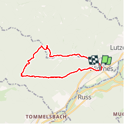
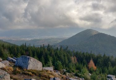
Trail Walking of 12.7 km to be discovered at Grand Est, Bas-Rhin, Wisches. This trail is proposed by VacheKiri67.
Description
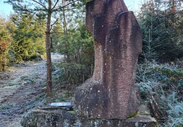
Balisage : disque rouge - chevalet jaune - rectange rouge-blanc-rouge.
Faite le 30/09/2012 en 4h10 (dont 0h30 de pause) avec notre fils de 8 ans.
Le balisage chevalet jaune n'est pas très visible !
Plus de détails : Passion Vosges - La Haute-Bruche N°1 Page 43 : La vallée du Netzenbach.
Positioning
Comments
Trails nearby
![Trail Walking Urmatt - Cascade Soultzbach - Urmatt - Photo](https://media.geolcdn.com/t/375/260/20e7652d-0a73-4a1a-a692-b5e1164e2be3.jpg&format=jpg&maxdim=2)
![Walking Walking](https://static1.geolcdn.com/sitytour/trail-icons/101.png)
Walking
![](/images/other/stat-length.png)
![](https://static1.geolcdn.com/siteimages/upload/files/16400158638029165_repeat_loop_refresh_sync_direction_icon.png)
![Trail Mountain bike Oberhaslach - Rando des Feuilles Mortes - Photo](https://media.geolcdn.com/t/375/260/ext.jpg?maxdim=2&url=https%3A%2F%2Fservices.sitytrail.com%2FGeolivesWS%2FDownloadMedia.ashx%3FTrailID%3D101060%26Media%3D551_1.jpg)
![Mountain bike Mountain bike](https://static1.geolcdn.com/sitytour/trail-icons/202.png)
Mountain bike
![](/images/other/stat-length.png)
![](https://static1.geolcdn.com/siteimages/upload/files/16400158638029165_repeat_loop_refresh_sync_direction_icon.png)
![Trail Walking La Broque - suuntoapp-Hiking-2024-03-17T08-46-21Z - Photo](https://media.geolcdn.com/t/375/260/ff165b4c-164b-4845-8566-1950893def08.jpg&format=jpg&maxdim=2)
![Walking Walking](https://static1.geolcdn.com/sitytour/trail-icons/101.png)
Walking
![](/images/other/stat-length.png)
![](https://static1.geolcdn.com/siteimages/upload/files/16400158638029165_repeat_loop_refresh_sync_direction_icon.png)
![Trail Walking Lutzelhouse - suuntoapp-Hiking-2024-01-28T11-41-12Z - Photo](https://media.geolcdn.com/t/375/260/a449e661-4c19-4b4c-bdec-0ce5cf123351.jpg&format=jpg&maxdim=2)
![Walking Walking](https://static1.geolcdn.com/sitytour/trail-icons/101.png)
Walking
![](/images/other/stat-length.png)
![](https://static1.geolcdn.com/siteimages/upload/files/16400158638029165_repeat_loop_refresh_sync_direction_icon.png)
![Trail Walking Grendelbruch - suuntoapp-Hiking-2024-01-21T12-04-41Z - Photo](https://media.geolcdn.com/t/375/260/4df6b66c-98a9-4be9-8660-05898a66c498.jpg&format=jpg&maxdim=2)
![Walking Walking](https://static1.geolcdn.com/sitytour/trail-icons/101.png)
Walking
![](/images/other/stat-length.png)
![](https://static1.geolcdn.com/siteimages/upload/files/16400158638029165_repeat_loop_refresh_sync_direction_icon.png)
![Trail Horseback riding Lutzelhouse - 2021-07-18 Journée Le petit Wisches Le Noll - Photo](https://media.geolcdn.com/t/375/260/39fea620-a06a-4b18-bd7a-fb2bce29910c.jpg&format=jpg&maxdim=2)
![Horseback riding Horseback riding](https://static1.geolcdn.com/sitytour/trail-icons/301.png)
Horseback riding
![](/images/other/stat-length.png)
![](https://static1.geolcdn.com/siteimages/upload/files/16400158638029165_repeat_loop_refresh_sync_direction_icon.png)
![Trail Walking Lutzelhouse - 2019-11-30 Marche Rocher de Mutzig Noll - Photo](https://media.geolcdn.com/t/375/260/f1ae836b-d063-4b16-aefc-2c8e07433ca1.jpg&format=jpg&maxdim=2)
![Walking Walking](https://static1.geolcdn.com/sitytour/trail-icons/101.png)
Walking
![](/images/other/stat-length.png)
![](https://static1.geolcdn.com/siteimages/upload/files/16400158638029165_repeat_loop_refresh_sync_direction_icon.png)
![Trail Horseback riding Wisches - 2019-08-24 Picnic Russ Colbery Abri du sanglier - Photo](https://media.geolcdn.com/t/375/260/78bbc276-2b62-45fd-8eef-58ba2dce73af.jpg&format=jpg&maxdim=2)
![Horseback riding Horseback riding](https://static1.geolcdn.com/sitytour/trail-icons/301.png)
Horseback riding
![](/images/other/stat-length.png)
![](https://static1.geolcdn.com/siteimages/upload/files/16400158638029165_repeat_loop_refresh_sync_direction_icon.png)
![Trail Walking Lutzelhouse - Lutzelhouse - place des musiciens - sculptures - grotte du loup - cascade de Soulzbach - Porte de pierre - Photo](https://media.geolcdn.com/t/375/260/3c8a3f56-9ea0-46c2-a96b-81a1c8bec17b.jpg&format=jpg&maxdim=2)
![Walking Walking](https://static1.geolcdn.com/sitytour/trail-icons/101.png)
Walking
![](/images/other/stat-length.png)
![](https://static1.geolcdn.com/siteimages/upload/files/16400158638029165_repeat_loop_refresh_sync_direction_icon.png)