![](/images/other/stat-length.png)
![Trail Walking Saint-Leu - Les crètes du Grand Bénare - Photo](https://media.geolcdn.com/t/1900/400/ext.pjpeg?maxdim=2&url=https%3A%2F%2Fstatic1.geolcdn.com%2Fsiteimages%2Fupload%2Ffiles%2F1553511878bg_sport_marche.png)
Les crètes du Grand Bénare
mferraci
User
![Length](/images/other/stat-length.png)
Length
18.7 km
![Max alt](https://static1.geolcdn.com/siteimages/upload/files/1508320355ic_sort_altitude_max_24dp.png)
Max alt
2893 m
![Uphill gradient](https://static1.geolcdn.com/siteimages/upload/files/1508320355ic_sort_den_pos_24dp.png)
Uphill gradient
1105 m
![Km-Effort](/images/other/stat-length.png)
Km-Effort
32 km
![Min alt](https://static1.geolcdn.com/siteimages/upload/files/1508320355ic_sort_altitude_min_24dp.png)
Min alt
1826 m
![Downhill gradient](https://static1.geolcdn.com/siteimages/upload/files/1508320355ic_sort_den_neg_24dp.png)
Downhill gradient
758 m
![Boucle](https://static1.geolcdn.com/siteimages/upload/files/16400158638029165_repeat_loop_refresh_sync_direction_icon.png)
Boucle
No
Creation date :
2016-03-09 00:00:00.0
Updated on :
2016-03-09 00:00:00.0
![Walking](https://static1.geolcdn.com/sitytour/trail-icons/101.png)
7h07
Difficulty : Unknown
![Scan this QR Code to open this trail in the SityTrail application](https://capi.geolives.com/qq0zvz2zws4bq2lad0pu/sitytour/trails/154501/qr.png?size=200)
FREE GPS app for hiking
About
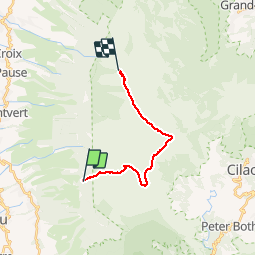
Trail Walking of 18.7 km to be discovered at Réunion, Unknown, Saint-Leu. This trail is proposed by mferraci.
Description
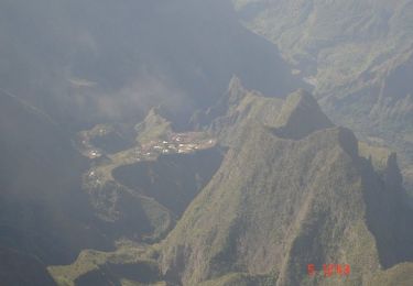
Le brulé de St-Leu, la Caverne du piton rouge, le petit Bénare, les crètes de Cilaos, le Grand Bénare et les crètes de Mafate jusqu'a Maido
Positioning
Country:
France
Region :
Réunion
Department/Province :
Unknown
Municipality :
Saint-Leu
Location:
Unknown
Start:(Dec)
Start:(UTM)
329819 ; 7661128 (40K) S.
Comments
Trails nearby
![Trail Walking Les Avirons - La Réunion - Boucle au Tevelave par le Sentier Grande Terre - Photo](https://media.geolcdn.com/t/375/260/ext.jpg?maxdim=2&url=https%3A%2F%2Fservices.sitytrail.com%2FGeolivesWS%2FDownloadMedia.ashx%3FTrailID%3D447253%26Media%3Dfix__20150719113959.jpg)
![Walking Walking](https://static1.geolcdn.com/sitytour/trail-icons/101.png)
La Réunion - Boucle au Tevelave par le Sentier Grande Terre
Walking
Easy
Les Avirons,
Réunion,
Unknown,
France
![](/images/other/stat-length.png)
11.2 km | 16.9 km-effort
4h 1min
![](https://static1.geolcdn.com/siteimages/upload/files/16400158638029165_repeat_loop_refresh_sync_direction_icon.png)
Yes
![Trail Walking Les Trois-Bassins - La Grande Ravine - Les Trois-Bassins - Photo](https://media.geolcdn.com/t/375/260/ext.jpg?maxdim=2&url=https%3A%2F%2Fservices.sitytrail.com%2FGeolivesWS%2FDownloadMedia.ashx%3FTrailID%3D317916%26Media%3D17334_6.jpg)
![Walking Walking](https://static1.geolcdn.com/sitytour/trail-icons/101.png)
La Grande Ravine - Les Trois-Bassins
Walking
Difficult
Les Trois-Bassins,
Réunion,
Unknown,
France
![](/images/other/stat-length.png)
21 km | 38 km-effort
6h 30min
![](https://static1.geolcdn.com/siteimages/upload/files/16400158638029165_repeat_loop_refresh_sync_direction_icon.png)
Yes
![Trail Electric bike Saint-Leu - Activity - Photo](https://media.geolcdn.com/t/375/260/ext.jpg?maxdim=2&url=https%3A%2F%2Fstatic1.geolcdn.com%2Fsiteimages%2Fupload%2Ffiles%2F1524743154velo.jpg)
![Electric bike Electric bike](https://static1.geolcdn.com/sitytour/trail-icons/205.png)
Activity
Electric bike
Difficult
Saint-Leu,
Réunion,
Unknown,
France
![](/images/other/stat-length.png)
49 km | 72 km-effort
Unknown
![](https://static1.geolcdn.com/siteimages/upload/files/16400158638029165_repeat_loop_refresh_sync_direction_icon.png)
Yes
![Trail Mountain bike Les Trois-Bassins - 2019 05 - LE TOUR DU MAIDO EN VTT PAR LES ROUTES FORESTIERES - Photo](https://media.geolcdn.com/t/375/260/ext.jpg?maxdim=2&url=https%3A%2F%2Fstatic1.geolcdn.com%2Fsiteimages%2Fupload%2Ffiles%2F1524743154velo.jpg)
![Mountain bike Mountain bike](https://static1.geolcdn.com/sitytour/trail-icons/202.png)
2019 05 - LE TOUR DU MAIDO EN VTT PAR LES ROUTES FORESTIERES
Mountain bike
Difficult
Les Trois-Bassins,
Réunion,
Unknown,
France
![](/images/other/stat-length.png)
34 km | 49 km-effort
2h 17min
![](https://static1.geolcdn.com/siteimages/upload/files/16400158638029165_repeat_loop_refresh_sync_direction_icon.png)
Yes
![Trail Walking Saint-Leu - TEST - Photo](https://media.geolcdn.com/t/375/260/ext.jpg?maxdim=2&url=https%3A%2F%2Fstatic1.geolcdn.com%2Fsiteimages%2Fupload%2Ffiles%2F1553511878bg_sport_marche.png)
![Walking Walking](https://static1.geolcdn.com/sitytour/trail-icons/101.png)
![Trail Walking Les Avirons - Sentier des tamarins, vue sur les Makes - Photo](https://media.geolcdn.com/t/375/260/ext.jpg?maxdim=2&url=https%3A%2F%2Fstatic1.geolcdn.com%2Fsiteimages%2Fupload%2Ffiles%2F1553511878bg_sport_marche.png)
![Walking Walking](https://static1.geolcdn.com/sitytour/trail-icons/101.png)
Sentier des tamarins, vue sur les Makes
Walking
Easy
Les Avirons,
Réunion,
Unknown,
France
![](/images/other/stat-length.png)
4.6 km | 7.7 km-effort
1h 38min
![](https://static1.geolcdn.com/siteimages/upload/files/16400158638029165_repeat_loop_refresh_sync_direction_icon.png)
Yes
![Trail Walking Saint-Leu - Piste des camélias- Tévelave - Photo](https://media.geolcdn.com/t/375/260/ext.jpg?maxdim=2&url=https%3A%2F%2Fstatic1.geolcdn.com%2Fsiteimages%2Fupload%2Ffiles%2F1553511878bg_sport_marche.png)
![Walking Walking](https://static1.geolcdn.com/sitytour/trail-icons/101.png)
Piste des camélias- Tévelave
Walking
Easy
Saint-Leu,
Réunion,
Unknown,
France
![](/images/other/stat-length.png)
7.2 km | 10.3 km-effort
2h 15min
![](https://static1.geolcdn.com/siteimages/upload/files/16400158638029165_repeat_loop_refresh_sync_direction_icon.png)
Yes
![Trail Walking Saint-Leu - Boucle au TEVELAVE, sentier des tamarins - Photo](https://media.geolcdn.com/t/375/260/ext.jpg?maxdim=2&url=https%3A%2F%2Fstatic1.geolcdn.com%2Fsiteimages%2Fupload%2Ffiles%2F1553511878bg_sport_marche.png)
![Walking Walking](https://static1.geolcdn.com/sitytour/trail-icons/101.png)
Boucle au TEVELAVE, sentier des tamarins
Walking
Medium
(1)
Saint-Leu,
Réunion,
Unknown,
France
![](/images/other/stat-length.png)
11 km | 16.9 km-effort
3h 36min
![](https://static1.geolcdn.com/siteimages/upload/files/16400158638029165_repeat_loop_refresh_sync_direction_icon.png)
Yes
![Trail Walking Les Trois-Bassins - Gîte des Tamarins au Grand Bènar. AR. - Photo](https://media.geolcdn.com/t/375/260/ext.jpg?maxdim=2&url=https%3A%2F%2Fstatic1.geolcdn.com%2Fsiteimages%2Fupload%2Ffiles%2F1553511878bg_sport_marche.png)
![Walking Walking](https://static1.geolcdn.com/sitytour/trail-icons/101.png)
Gîte des Tamarins au Grand Bènar. AR.
Walking
Medium
Les Trois-Bassins,
Réunion,
Unknown,
France
![](/images/other/stat-length.png)
15.9 km | 31 km-effort
6h 14min
![](https://static1.geolcdn.com/siteimages/upload/files/16400158638029165_repeat_loop_refresh_sync_direction_icon.png)
Yes
pas utile