Trail Walking La Giettaz - Tour du Croisse Baulet - Photo

Tour du Croisse Baulet

 biollay
biollay

User

© OpenStreetMap contributors
Length
Length
13.5 km
Max alt
Max alt
2101 m
Uphill gradient
Uphill gradient
948 m
Km-Effort
Km-Effort  
26 km
Min alt
Min alt
1224 m
Downhill gradient
Downhill gradient
950 m
Boucle
Boucle
Yes
Creation date :
2019-06-29 13:12:38.868
Updated on :
2019-06-29 13:12:39.771

(0 Reviews)

Walking
Walking
4h00
Difficulty : Difficult

Scan this QR Code to open this trail in the SityTrail application

FREE GPS app for hiking

Logo SityTrail SityTrail

IGN / Geographical institutes

Download SityTrail from the App Store Download SityTrail from Google Play

Logo SityTrail SityTrail World

The world is yours!

Download SityTrail from the App Store Download SityTrail from Google Play Download SityTrail on Huawei AppGallery

About

Trail Walking of 13.5 km to be discovered at Auvergne-Rhône-Alpes, Savoy, La Giettaz. This trail is proposed by biollay.

Description

Superbe randonnée autour du Croisse Baulet. Vous partez de La Giettaz (Savoie), parcoure-rez des sous bois, des alpages, survolerez des plaines, vous epoustouflerez devant le Mont Blanc.

Elevation profile

Positioning

Country:
France
Region :
Auvergne-Rhône-Alpes
Department/Province :
Savoy
Municipality :
La Giettaz
Location:
Unknown
Start:(UTM)
307927 ; 5083650 (32T) N.

Trails nearby

Trail Walking La Giettaz - Le Plan - col de Jaillet - Photo
Walking
wbarge

Walking

Medium
(2)
La Giettaz, Auvergne-Rhône-Alpes, Savoy, France
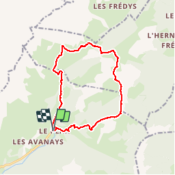
11.9 km | 19.7 km-effort
4h 18min
Yes
Trail Walking La Giettaz - Boucle de Croisse Baulet - Photo
Walking
olivecoco

Walking

Medium
(1)
La Giettaz, Auvergne-Rhône-Alpes, Savoy, France
9.4 km | 23 km-effort
4h 2min
Yes
Trail Snowshoes La Clusaz - col aravis - Photo
Snowshoes
myjackotte

Snowshoes

Easy
(2)
La Clusaz, Auvergne-Rhône-Alpes, Upper Savoy, France
5.7 km | 8.2 km-effort
2h 16min
Yes
Trail Walking La Clusaz - confins - Trou de la mouche - Photo
Walking
sofracoan

Walking

Medium
(1)
La Clusaz, Auvergne-Rhône-Alpes, Upper Savoy, France
9.5 km | 23 km-effort
4h 38min
Yes
Trail Other activity La Giettaz - croise baulet - Photo
Other activity
twistss

Other activity

Very easy
(3)
La Giettaz, Auvergne-Rhône-Alpes, Savoy, France
12.1 km | 27 km-effort
3h 30min
Yes
Trail Motor La Giettaz - La Giettaz - Col des Aravis - Photo
Motor
albertville

Motor

Very easy
(1)
La Giettaz, Auvergne-Rhône-Alpes, Savoy, France
15.8 km | 23 km-effort
58min
No
Trail Walking La Clusaz - TROU DE LA MOUCHE - Photo
Walking
Jean-Paulchoux

Walking

Difficult
La Clusaz, Auvergne-Rhône-Alpes, Upper Savoy, France
10 km | 24 km-effort
6h 7min
Yes
Trail Walking La Clusaz - Col des ARAVIS ... la Croix des Frêtes. - Photo
Walking
GerardBouche

Walking

Difficult
La Clusaz, Auvergne-Rhône-Alpes, Upper Savoy, France
7.4 km | 12.1 km-effort
2h 14min
Yes
Trail Walking La Clusaz - La CLUSAZ  ... la Tête du Danay. - Photo
Walking
GerardBouche

Walking

Medium
La Clusaz, Auvergne-Rhône-Alpes, Upper Savoy, France
8.2 km | 13.8 km-effort
2h 32min
Yes


Close
My subscriptions