![](/images/other/stat-length.png)
![Trail Mountain bike Montigny-le-Bretonneux - Rando des renards 35k - Photo](https://media.geolcdn.com/t/1900/400/ext.pjpeg?maxdim=2&url=https%3A%2F%2Fstatic1.geolcdn.com%2Fsiteimages%2Fupload%2Ffiles%2F1524743154velo.jpg)
Rando des renards 35k
guariso
User
![Length](/images/other/stat-length.png)
Length
38 km
![Max alt](https://static1.geolcdn.com/siteimages/upload/files/1508320355ic_sort_altitude_max_24dp.png)
Max alt
180 m
![Uphill gradient](https://static1.geolcdn.com/siteimages/upload/files/1508320355ic_sort_den_pos_24dp.png)
Uphill gradient
580 m
![Km-Effort](/images/other/stat-length.png)
Km-Effort
46 km
![Min alt](https://static1.geolcdn.com/siteimages/upload/files/1508320355ic_sort_altitude_min_24dp.png)
Min alt
92 m
![Downhill gradient](https://static1.geolcdn.com/siteimages/upload/files/1508320355ic_sort_den_neg_24dp.png)
Downhill gradient
580 m
![Boucle](https://static1.geolcdn.com/siteimages/upload/files/16400158638029165_repeat_loop_refresh_sync_direction_icon.png)
Boucle
Yes
Creation date :
2014-12-10 00:00:00.0
Updated on :
2014-12-10 00:00:00.0
![Mountain bike](https://static1.geolcdn.com/sitytour/trail-icons/202.png)
2h50
Difficulty : Medium
![Scan this QR Code to open this trail in the SityTrail application](https://capi.geolives.com/qq0zvz2zws4bq2lad0pu/sitytour/trails/152876/qr.png?size=200)
FREE GPS app for hiking
About
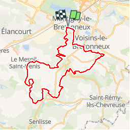
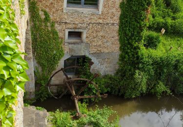
Trail Mountain bike of 38 km to be discovered at Ile-de-France, Yvelines, Montigny-le-Bretonneux. This trail is proposed by guariso.
Description
Pour la fête du VTT, le club de Montigny le bretoneux organisait le 9/9/12 4 parcours de VTT, dont un 35km assez technique malgré tout.
Positioning
Country:
France
Region :
Ile-de-France
Department/Province :
Yvelines
Municipality :
Montigny-le-Bretonneux
Location:
Unknown
Start:(Dec)
Start:(UTM)
428004 ; 5402576 (31U) N.
Comments
Trails nearby
![Trail Walking Magny-les-Hameaux - _La Vallée de la Mérantaise - Photo](https://media.geolcdn.com/t/375/260/ext.jpg?maxdim=2&url=https%3A%2F%2Fservices.sitytrail.com%2FGeolivesWS%2FDownloadMedia.ashx%3FTrailID%3D755616%26Media%3Deae23003-4ad7-4454-b083-3d96818374a8.jpg)
![Walking Walking](https://static1.geolcdn.com/sitytour/trail-icons/101.png)
_La Vallée de la Mérantaise
Walking
Easy
(5)
Magny-les-Hameaux,
Ile-de-France,
Yvelines,
France
![](/images/other/stat-length.png)
9.7 km | 11.6 km-effort
2h 30min
![](https://static1.geolcdn.com/siteimages/upload/files/16400158638029165_repeat_loop_refresh_sync_direction_icon.png)
Yes
![Trail Walking Le Mesnil-Saint-Denis - _Entre ancienne châtellenie et Ville nouvelle - Photo](https://media.geolcdn.com/t/375/260/ext.jpg?maxdim=2&url=https%3A%2F%2Fservices.sitytrail.com%2FGeolivesWS%2FDownloadMedia.ashx%3FTrailID%3D754427%26Media%3D98bcb1fa-3e08-461c-9cfd-0202e71bacca.png)
![Walking Walking](https://static1.geolcdn.com/sitytour/trail-icons/101.png)
_Entre ancienne châtellenie et Ville nouvelle
Walking
Easy
(1)
Le Mesnil-Saint-Denis,
Ile-de-France,
Yvelines,
France
![](/images/other/stat-length.png)
8.6 km | 9.5 km-effort
2h 30min
![](https://static1.geolcdn.com/siteimages/upload/files/16400158638029165_repeat_loop_refresh_sync_direction_icon.png)
Yes
![Trail Walking Saint-Lambert - _Sur les pas de Racine (deuxième partie) - Photo](https://media.geolcdn.com/t/375/260/ext.jpg?maxdim=2&url=https%3A%2F%2Fservices.sitytrail.com%2FGeolivesWS%2FDownloadMedia.ashx%3FTrailID%3D745749%26Media%3Db1edb432-b6c8-43f7-9f4b-66b807e05156.jpg)
![Walking Walking](https://static1.geolcdn.com/sitytour/trail-icons/101.png)
_Sur les pas de Racine (deuxième partie)
Walking
Easy
(2)
Saint-Lambert,
Ile-de-France,
Yvelines,
France
![](/images/other/stat-length.png)
10.5 km | 12.5 km-effort
2h 30min
![](https://static1.geolcdn.com/siteimages/upload/files/16400158638029165_repeat_loop_refresh_sync_direction_icon.png)
Yes
![Trail Walking Magny-les-Hameaux - Merantaise réel - Photo](https://media.geolcdn.com/t/375/260/4d2164f2-d361-4db7-b056-eb385e9bacad.jpeg&format=jpg&maxdim=2)
![Walking Walking](https://static1.geolcdn.com/sitytour/trail-icons/101.png)
Merantaise réel
Walking
Difficult
(1)
Magny-les-Hameaux,
Ile-de-France,
Yvelines,
France
![](/images/other/stat-length.png)
11.3 km | 14.2 km-effort
3h 18min
![](https://static1.geolcdn.com/siteimages/upload/files/16400158638029165_repeat_loop_refresh_sync_direction_icon.png)
Yes
![Trail Walking Magny-les-Hameaux - Boucle 23 km à partir de Port Royal des Champs - Photo](https://media.geolcdn.com/t/375/260/9a76b572-9029-4a25-99b4-82cf64e08344.jpg&format=jpg&maxdim=2)
![Walking Walking](https://static1.geolcdn.com/sitytour/trail-icons/101.png)
Boucle 23 km à partir de Port Royal des Champs
Walking
Easy
Magny-les-Hameaux,
Ile-de-France,
Yvelines,
France
![](/images/other/stat-length.png)
23 km | 28 km-effort
4h 56min
![](https://static1.geolcdn.com/siteimages/upload/files/16400158638029165_repeat_loop_refresh_sync_direction_icon.png)
Yes
![Trail Mountain bike Saint-Cyr-l'École - 14102013 - Photo](https://media.geolcdn.com/t/375/260/ext.jpg?maxdim=2&url=https%3A%2F%2Fstatic1.geolcdn.com%2Fsiteimages%2Fupload%2Ffiles%2F1524743154velo.jpg)
![Mountain bike Mountain bike](https://static1.geolcdn.com/sitytour/trail-icons/202.png)
14102013
Mountain bike
Medium
(1)
Saint-Cyr-l'École,
Ile-de-France,
Yvelines,
France
![](/images/other/stat-length.png)
42 km | 50 km-effort
3h 11min
![](https://static1.geolcdn.com/siteimages/upload/files/16400158638029165_repeat_loop_refresh_sync_direction_icon.png)
Yes
![Trail sport Saint-Lambert - Balade Chevreuse - Photo](https://media.geolcdn.com/t/375/260/e72ebaec-ed2d-40a4-87cd-15a387dcd994.jpg&format=jpg&maxdim=2)
Balade Chevreuse
sport
Very easy
Saint-Lambert,
Ile-de-France,
Yvelines,
France
![](/images/other/stat-length.png)
12 km | 15.8 km-effort
Unknown
![](https://static1.geolcdn.com/siteimages/upload/files/16400158638029165_repeat_loop_refresh_sync_direction_icon.png)
Yes
![Trail Running Voisins-le-Bretonneux - domaine d'Or - Photo](https://media.geolcdn.com/t/375/260/cd206760-3d6b-4c1c-979c-7a5d20ed9e8c.jpg&format=jpg&maxdim=2)
![Running Running](https://static1.geolcdn.com/sitytour/trail-icons/103.png)
domaine d'Or
Running
Medium
Voisins-le-Bretonneux,
Ile-de-France,
Yvelines,
France
![](/images/other/stat-length.png)
17.3 km | 19.7 km-effort
2h 53min
![](https://static1.geolcdn.com/siteimages/upload/files/16400158638029165_repeat_loop_refresh_sync_direction_icon.png)
Yes
![Trail Walking Voisins-le-Bretonneux - 220326 parcours commenté val st Quentin Grde Ile - Photo](https://media.geolcdn.com/t/375/260/570f897f-35d8-43ed-91a7-7f12cf354eaa.jpg&format=jpg&maxdim=2)
![Walking Walking](https://static1.geolcdn.com/sitytour/trail-icons/101.png)
220326 parcours commenté val st Quentin Grde Ile
Walking
Medium
Voisins-le-Bretonneux,
Ile-de-France,
Yvelines,
France
![](/images/other/stat-length.png)
6.8 km | 7.3 km-effort
1h 32min
![](https://static1.geolcdn.com/siteimages/upload/files/16400158638029165_repeat_loop_refresh_sync_direction_icon.png)
No