Trail Cycle Blois - Blois-Cheverny - Photo
 leeho
leeho

User

© OpenStreetMap contributors
Length
Length
41 km
Max alt
Max alt
120 m
Uphill gradient
Uphill gradient
332 m
Km-Effort
Km-Effort  
45 km
Min alt
Min alt
65 m
Downhill gradient
Downhill gradient
334 m
Boucle
Boucle
No
Creation date :
2014-12-10 00:00:00.0
Updated on :
2014-12-10 00:00:00.0

(0 Reviews)

Cycle
Cycle
1h30
Difficulty : Easy

Scan this QR Code to open this trail in the SityTrail application

FREE GPS app for hiking

Logo SityTrail SityTrail

IGN / Geographical institutes

Download SityTrail from the App Store Download SityTrail from Google Play

Logo SityTrail SityTrail World

The world is yours!

Download SityTrail from the App Store Download SityTrail from Google Play Download SityTrail on Huawei AppGallery

About

Trail Cycle of 41 km to be discovered at Centre-Loire Valley, Loir-et-Cher, Blois. This trail is proposed by leeho.

Description

De Blois à Cour-Cheverny en passant par Chambord. Itinéraire proposé par "Le Vélo voyageur". Départ de l'hôtel de France et de Guise, rue Gallois à Blois.

Elevation profile

Points of interest

Point of interest Chambord - Chateau de Chambord - Photo
leeho
Point of interest Bracieux - 8 - Photo
leeho
BRACIEUX 
Point of interest Tour-en-Sologne - Château de Villesavin - Photo
leeho
TOUR-EN-SOLOGNE 
Point of interest Cour-Cheverny - Au Relais de Saint Hubert - Photo
leeho
Point of interest Blois - 1 - Photo
leeho
BLOIS 
Point of interest Blois - 2 - Photo
leeho
BLOIS 
Point of interest Vineuil - 3 - Photo
leeho
VINEUIL 
Point of interest Vineuil - 4 - Photo
leeho
VINEUIL 
Point of interest Vineuil - 5 - Photo
leeho
VINEUIL 
Point of interest Huisseau-sur-Cosson - 6 - Photo
leeho
HUISSEAU-SUR-COSSON 
Point of interest Chambord - 7 - Photo
leeho
CHAMBORD 
Point of interest Tour-en-Sologne - 9 - Photo
leeho
TOUR-EN-SOLOGNE 
Point of interest Cour-Cheverny - 10 - Photo
leeho
COUR-CHEVERNY 

Positioning

Country:
France
Region :
Centre-Loire Valley
Department/Province :
Loir-et-Cher
Municipality :
Blois
Location:
Unknown
Start:(UTM)
374479 ; 5271724 (31T) N.

Trails nearby

Trail Walking Vineuil - Loire 2 - Photo
Walking
domlecar

Walking

Very easy
(1)
Vineuil, Centre-Loire Valley, Loir-et-Cher, France
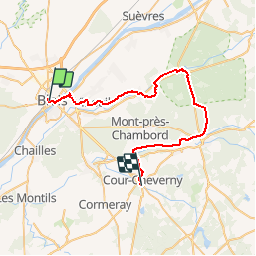
18.2 km | 19.5 km-effort
2h 46min
Yes
Trail Walking Vineuil - Vineuil le viaduc via la Noue Château de Ménard  - Photo
Walking
jouhan

Walking

Medium
Vineuil, Centre-Loire Valley, Loir-et-Cher, France
11.9 km | 12.5 km-effort
2h 30min
Yes
Trail Walking Saint-Gervais-la-Forêt - Saint-Gervais-la-Forêt - Chailles - Photo
Walking
guydu41

Walking

Easy
Saint-Gervais-la-Forêt, Centre-Loire Valley, Loir-et-Cher, France
9.1 km | 11.4 km-effort
2h 43min
Yes
Trail Walking Saint-Sulpice-de-Pommeray - Saint-Sulpice-de-Pommeray - Photo
Walking
guydu41

Walking

Medium
Saint-Sulpice-de-Pommeray, Centre-Loire Valley, Loir-et-Cher, France
24 km | 29 km-effort
8h 41min
Yes
Trail Hybrid bike Blois - Blois Chambord et retour - Photo
Hybrid bike
tbrunet

Hybrid bike

Easy
Blois, Centre-Loire Valley, Loir-et-Cher, France
49 km | 54 km-effort
5h 13min
Yes
Trail Walking Blois - blois - Photo
Walking
pistou

Walking

Medium
Blois, Centre-Loire Valley, Loir-et-Cher, France
5.6 km | 6.4 km-effort
4h 10min
No
Trail Walking Saint-Gervais-la-Forêt - La Chaussée St Victor  - Photo
Walking
mimilolo

Walking

Very easy
Saint-Gervais-la-Forêt, Centre-Loire Valley, Loir-et-Cher, France
13.5 km | 15.7 km-effort
2h 44min
Yes
Trail Walking Vineuil - Mardi 9 juillet 2019 - Saint-Gervais-la-Foret - seule  - Photo
Walking
brigitte lecarpentier

Walking

Vineuil, Centre-Loire Valley, Loir-et-Cher, France
6.9 km | 7.7 km-effort
1h 31min
No
Trail Walking Vineuil - Vineuil centre - Photo
Walking
caillé

Walking

Medium
Vineuil, Centre-Loire Valley, Loir-et-Cher, France
10.4 km | 11.5 km-effort
53min
Yes


Close
My subscriptions