![](/images/other/stat-length.png)
![Trail Running Ménil-Hubert-en-Exmes - Trail Menil Hubert - Photo](https://media.geolcdn.com/t/1900/400/ext.pjpeg?maxdim=2&url=https%3A%2F%2Fstatic1.geolcdn.com%2Fsiteimages%2Fupload%2Ffiles%2F1524743154running.jpg)
Trail Menil Hubert
sylvain75
User
![Length](/images/other/stat-length.png)
Length
16.4 km
![Max alt](https://static1.geolcdn.com/siteimages/upload/files/1508320355ic_sort_altitude_max_24dp.png)
Max alt
279 m
![Uphill gradient](https://static1.geolcdn.com/siteimages/upload/files/1508320355ic_sort_den_pos_24dp.png)
Uphill gradient
370 m
![Km-Effort](/images/other/stat-length.png)
Km-Effort
21 km
![Min alt](https://static1.geolcdn.com/siteimages/upload/files/1508320355ic_sort_altitude_min_24dp.png)
Min alt
153 m
![Downhill gradient](https://static1.geolcdn.com/siteimages/upload/files/1508320355ic_sort_den_neg_24dp.png)
Downhill gradient
369 m
![Boucle](https://static1.geolcdn.com/siteimages/upload/files/16400158638029165_repeat_loop_refresh_sync_direction_icon.png)
Boucle
Yes
Creation date :
2014-12-10 00:00:00.0
Updated on :
2014-12-10 00:00:00.0
![Running](https://static1.geolcdn.com/sitytour/trail-icons/103.png)
--
Difficulty : Medium
![Scan this QR Code to open this trail in the SityTrail application](https://capi.geolives.com/qq0zvz2zws4bq2lad0pu/sitytour/trails/151522/qr.png?size=200)
FREE GPS app for hiking
About
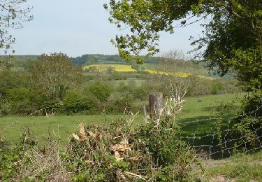
Trail Running of 16.4 km to be discovered at Normandy, Orne, Ménil-Hubert-en-Exmes. This trail is proposed by sylvain75.
Description
Varié, pas trop difficile, très plaisant. A faire dans les deux sens.
Parcours pouvant être raccourcis ou allongé de multiples façons.
Positioning
Country:
France
Region :
Normandy
Department/Province :
Orne
Municipality :
Ménil-Hubert-en-Exmes
Location:
Unknown
Start:(Dec)
Start:(UTM)
296604 ; 5410500 (31U) N.
Comments
Trails nearby
![Trail Mountain bike Gacé - Forêt de Chaumont - Gacé - Photo](https://media.geolcdn.com/t/375/260/ext.jpg?maxdim=2&url=https%3A%2F%2Fservices.sitytrail.com%2FGeolivesWS%2FDownloadMedia.ashx%3FTrailID%3D105295%26Media%3D8981_3.jpg)
![Mountain bike Mountain bike](https://static1.geolcdn.com/sitytour/trail-icons/202.png)
Forêt de Chaumont - Gacé
Mountain bike
Difficult
Gacé,
Normandy,
Orne,
France
![](/images/other/stat-length.png)
27 km | 33 km-effort
2h 30min
![](https://static1.geolcdn.com/siteimages/upload/files/16400158638029165_repeat_loop_refresh_sync_direction_icon.png)
Yes
![Trail Mountain bike Gacé - Espace VTT FFC du Pays d'Auge Ornais- Circuit n°10 - Tour de Résenlieu - Photo](https://media.geolcdn.com/t/375/260/ext.jpg?maxdim=2&url=https%3A%2F%2Fservices.sitytrail.com%2FGeolivesWS%2FDownloadMedia.ashx%3FTrailID%3D101955%26Media%3D2247_1.jpg)
![Mountain bike Mountain bike](https://static1.geolcdn.com/sitytour/trail-icons/202.png)
Espace VTT FFC du Pays d'Auge Ornais- Circuit n°10 - Tour de Résenlieu
Mountain bike
Medium
Gacé,
Normandy,
Orne,
France
![](/images/other/stat-length.png)
8.3 km | 10.9 km-effort
30min
![](https://static1.geolcdn.com/siteimages/upload/files/16400158638029165_repeat_loop_refresh_sync_direction_icon.png)
Yes
![Trail Mountain bike Gacé - Espace VTT FFC du Pays d'Auge Ornais- Circuit n°9 - St Evroult de Montfort - Photo](https://media.geolcdn.com/t/375/260/ext.jpg?maxdim=2&url=https%3A%2F%2Fservices.sitytrail.com%2FGeolivesWS%2FDownloadMedia.ashx%3FTrailID%3D101954%26Media%3D2246_1.jpg)
![Mountain bike Mountain bike](https://static1.geolcdn.com/sitytour/trail-icons/202.png)
Espace VTT FFC du Pays d'Auge Ornais- Circuit n°9 - St Evroult de Montfort
Mountain bike
Medium
Gacé,
Normandy,
Orne,
France
![](/images/other/stat-length.png)
11.1 km | 14.5 km-effort
40min
![](https://static1.geolcdn.com/siteimages/upload/files/16400158638029165_repeat_loop_refresh_sync_direction_icon.png)
Yes
![Trail Mountain bike Gacé - Espace VTT FFC du Pays d'Auge Ornais- Circuit n°8 - Vallée de la Touques - Photo](https://media.geolcdn.com/t/375/260/ext.jpg?maxdim=2&url=https%3A%2F%2Fservices.sitytrail.com%2FGeolivesWS%2FDownloadMedia.ashx%3FTrailID%3D101953%26Media%3D2245_1.jpg)
![Mountain bike Mountain bike](https://static1.geolcdn.com/sitytour/trail-icons/202.png)
Espace VTT FFC du Pays d'Auge Ornais- Circuit n°8 - Vallée de la Touques
Mountain bike
Difficult
Gacé,
Normandy,
Orne,
France
![](/images/other/stat-length.png)
29 km | 37 km-effort
2h 30min
![](https://static1.geolcdn.com/siteimages/upload/files/16400158638029165_repeat_loop_refresh_sync_direction_icon.png)
Yes
![Trail Walking Neuville-sur-Touques - NEUVILLE SUR TOUQUES (boucle) - Photo](https://media.geolcdn.com/t/375/260/ext.jpg?maxdim=2&url=https%3A%2F%2Fstatic1.geolcdn.com%2Fsiteimages%2Fupload%2Ffiles%2F1553511878bg_sport_marche.png)
![Walking Walking](https://static1.geolcdn.com/sitytour/trail-icons/101.png)
NEUVILLE SUR TOUQUES (boucle)
Walking
Medium
Neuville-sur-Touques,
Normandy,
Orne,
France
![](/images/other/stat-length.png)
17.8 km | 21 km-effort
4h 37min
![](https://static1.geolcdn.com/siteimages/upload/files/16400158638029165_repeat_loop_refresh_sync_direction_icon.png)
Yes
![Trail Horseback riding Mardilly - Equirando essai tracé général - Photo](https://media.geolcdn.com/t/375/260/ext.jpg?maxdim=2&url=https%3A%2F%2Fstatic1.geolcdn.com%2Fsiteimages%2Fupload%2Ffiles%2F1524743154cheval.jpg)
![Horseback riding Horseback riding](https://static1.geolcdn.com/sitytour/trail-icons/301.png)
Equirando essai tracé général
Horseback riding
Very difficult
Mardilly,
Normandy,
Orne,
France
![](/images/other/stat-length.png)
112 km | 134 km-effort
17h 39min
![](https://static1.geolcdn.com/siteimages/upload/files/16400158638029165_repeat_loop_refresh_sync_direction_icon.png)
No
![Trail Walking Gouffern en Auge - Saint Pierre Orne - Photo](https://media.geolcdn.com/t/375/260/ext.jpg?maxdim=2&url=https%3A%2F%2Fstatic1.geolcdn.com%2Fsiteimages%2Fupload%2Ffiles%2F1553511878bg_sport_marche.png)
![Walking Walking](https://static1.geolcdn.com/sitytour/trail-icons/101.png)
Saint Pierre Orne
Walking
Difficult
Gouffern en Auge,
Normandy,
Orne,
France
![](/images/other/stat-length.png)
12.2 km | 15.4 km-effort
3h 22min
![](https://static1.geolcdn.com/siteimages/upload/files/16400158638029165_repeat_loop_refresh_sync_direction_icon.png)
Yes
![Trail Mountain bike Gouffern en Auge - la vimonderie orval vimoutier - Photo](https://media.geolcdn.com/t/375/260/ext.jpg?maxdim=2&url=https%3A%2F%2Fstatic1.geolcdn.com%2Fsiteimages%2Fupload%2Ffiles%2F1524743154velo.jpg)
![Mountain bike Mountain bike](https://static1.geolcdn.com/sitytour/trail-icons/202.png)
la vimonderie orval vimoutier
Mountain bike
Difficult
Gouffern en Auge,
Normandy,
Orne,
France
![](/images/other/stat-length.png)
30 km | 39 km-effort
4h 30min
![](https://static1.geolcdn.com/siteimages/upload/files/16400158638029165_repeat_loop_refresh_sync_direction_icon.png)
No
![Trail Walking Gacé - Face (61) - Photo](https://media.geolcdn.com/t/375/260/ext.jpg?maxdim=2&url=https%3A%2F%2Fstatic1.geolcdn.com%2Fsiteimages%2Fupload%2Ffiles%2F1553511878bg_sport_marche.png)
![Walking Walking](https://static1.geolcdn.com/sitytour/trail-icons/101.png)