![](/images/other/stat-length.png)
![Trail Mountain bike Senillé-Saint-Sauveur - Zevtt - Senillé 2012 - Photo](https://media.geolcdn.com/t/1900/400/ext.pjpeg?maxdim=2&url=https%3A%2F%2Fstatic1.geolcdn.com%2Fsiteimages%2Fupload%2Ffiles%2F1524743154velo.jpg)
Zevtt - Senillé 2012
kipoura
User
![Length](/images/other/stat-length.png)
Length
51 km
![Max alt](https://static1.geolcdn.com/siteimages/upload/files/1508320355ic_sort_altitude_max_24dp.png)
Max alt
150 m
![Uphill gradient](https://static1.geolcdn.com/siteimages/upload/files/1508320355ic_sort_den_pos_24dp.png)
Uphill gradient
760 m
![Km-Effort](/images/other/stat-length.png)
Km-Effort
61 km
![Min alt](https://static1.geolcdn.com/siteimages/upload/files/1508320355ic_sort_altitude_min_24dp.png)
Min alt
61 m
![Downhill gradient](https://static1.geolcdn.com/siteimages/upload/files/1508320355ic_sort_den_neg_24dp.png)
Downhill gradient
760 m
![Boucle](https://static1.geolcdn.com/siteimages/upload/files/16400158638029165_repeat_loop_refresh_sync_direction_icon.png)
Boucle
Yes
Creation date :
2019-05-03 17:10:28.792
Updated on :
2019-05-03 17:10:29.092
![Mountain bike](https://static1.geolcdn.com/sitytour/trail-icons/202.png)
--
Difficulty : Difficult
![Scan this QR Code to open this trail in the SityTrail application](https://capi.geolives.com/qq0zvz2zws4bq2lad0pu/sitytour/trails/149972/qr.png?size=200)
FREE GPS app for hiking
About
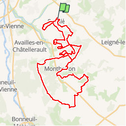
Trail Mountain bike of 51 km to be discovered at New Aquitaine, Vienne, Senillé-Saint-Sauveur. This trail is proposed by kipoura.
Description
Un superbe parcours VTT d'une cinquantaine de kilomètres au départ de Senillé. Un cocktail de passage ludiques, techniques et physiques ... bonne condition physique souhaitable .....
Positioning
Country:
France
Region :
New Aquitaine
Department/Province :
Vienne
Municipality :
Senillé-Saint-Sauveur
Location:
Senillé
Start:(Dec)
Start:(UTM)
318088 ; 5183650 (31T) N.
Comments
Trails nearby
![Walking Walking](https://static1.geolcdn.com/sitytour/trail-icons/101.png)
Availles Chitré
Walking
Medium
Availles-en-Châtellerault,
New Aquitaine,
Vienne,
France
![](/images/other/stat-length.png)
6.2 km | 7.7 km-effort
1h 35min
![](https://static1.geolcdn.com/siteimages/upload/files/16400158638029165_repeat_loop_refresh_sync_direction_icon.png)
Yes
![Walking Walking](https://static1.geolcdn.com/sitytour/trail-icons/101.png)
Prinçay 4,2
Walking
Availles-en-Châtellerault,
New Aquitaine,
Vienne,
France
![](/images/other/stat-length.png)
4.6 km | 5.3 km-effort
1h 7min
![](https://static1.geolcdn.com/siteimages/upload/files/16400158638029165_repeat_loop_refresh_sync_direction_icon.png)
Yes
![Trail Walking Availles-en-Châtellerault - Availles-en-Châtellerault - les Fombeurs - Photo](https://media.geolcdn.com/t/375/260/ext.jpg?maxdim=2&url=https%3A%2F%2Fstatic1.geolcdn.com%2Fsiteimages%2Fupload%2Ffiles%2F1553511878bg_sport_marche.png)
![Walking Walking](https://static1.geolcdn.com/sitytour/trail-icons/101.png)
Availles-en-Châtellerault - les Fombeurs
Walking
Medium
Availles-en-Châtellerault,
New Aquitaine,
Vienne,
France
![](/images/other/stat-length.png)
8.2 km | 9.3 km-effort
2h 6min
![](https://static1.geolcdn.com/siteimages/upload/files/16400158638029165_repeat_loop_refresh_sync_direction_icon.png)
Yes
![Trail Walking Availles-en-Châtellerault - Availles en Châtellerault les Fontenelles - Photo](https://media.geolcdn.com/t/375/260/ext.jpg?maxdim=2&url=https%3A%2F%2Fstatic1.geolcdn.com%2Fsiteimages%2Fupload%2Ffiles%2F1553511878bg_sport_marche.png)
![Walking Walking](https://static1.geolcdn.com/sitytour/trail-icons/101.png)
Availles en Châtellerault les Fontenelles
Walking
Medium
Availles-en-Châtellerault,
New Aquitaine,
Vienne,
France
![](/images/other/stat-length.png)
8.2 km | 9.1 km-effort
2h 4min
![](https://static1.geolcdn.com/siteimages/upload/files/16400158638029165_repeat_loop_refresh_sync_direction_icon.png)
Yes
![Trail Walking Availles-en-Châtellerault - Availles-en-Châtellerault le Magnou - Photo](https://media.geolcdn.com/t/375/260/ext.jpg?maxdim=2&url=https%3A%2F%2Fstatic1.geolcdn.com%2Fsiteimages%2Fupload%2Ffiles%2F1553511878bg_sport_marche.png)
![Walking Walking](https://static1.geolcdn.com/sitytour/trail-icons/101.png)
Availles-en-Châtellerault le Magnou
Walking
Easy
Availles-en-Châtellerault,
New Aquitaine,
Vienne,
France
![](/images/other/stat-length.png)
4.9 km | 5.3 km-effort
1h 12min
![](https://static1.geolcdn.com/siteimages/upload/files/16400158638029165_repeat_loop_refresh_sync_direction_icon.png)
Yes
![Trail Walking Availles-en-Châtellerault - Essai - Photo](https://media.geolcdn.com/t/375/260/ext.jpg?maxdim=2&url=https%3A%2F%2Fstatic1.geolcdn.com%2Fsiteimages%2Fupload%2Ffiles%2F1553511878bg_sport_marche.png)
![Walking Walking](https://static1.geolcdn.com/sitytour/trail-icons/101.png)
Essai
Walking
Easy
Availles-en-Châtellerault,
New Aquitaine,
Vienne,
France
![](/images/other/stat-length.png)
4.2 km | 5.1 km-effort
1h 9min
![](https://static1.geolcdn.com/siteimages/upload/files/16400158638029165_repeat_loop_refresh_sync_direction_icon.png)
Yes
![Trail Walking Availles-en-Châtellerault - Availles Prinçay - Photo](https://media.geolcdn.com/t/375/260/ext.jpg?maxdim=2&url=https%3A%2F%2Fstatic1.geolcdn.com%2Fsiteimages%2Fupload%2Ffiles%2F1553511878bg_sport_marche.png)
![Walking Walking](https://static1.geolcdn.com/sitytour/trail-icons/101.png)
Availles Prinçay
Walking
Easy
Availles-en-Châtellerault,
New Aquitaine,
Vienne,
France
![](/images/other/stat-length.png)
8.2 km | 9.6 km-effort
Unknown
![](https://static1.geolcdn.com/siteimages/upload/files/16400158638029165_repeat_loop_refresh_sync_direction_icon.png)
Yes
![Trail Walking Availles-en-Châtellerault - Availles-en-Châtellerault 4,6 - Photo](https://media.geolcdn.com/t/375/260/ext.jpg?maxdim=2&url=https%3A%2F%2Fstatic1.geolcdn.com%2Fsiteimages%2Fupload%2Ffiles%2F1553511878bg_sport_marche.png)
![Walking Walking](https://static1.geolcdn.com/sitytour/trail-icons/101.png)
Availles-en-Châtellerault 4,6
Walking
Easy
Availles-en-Châtellerault,
New Aquitaine,
Vienne,
France
![](/images/other/stat-length.png)
4.6 km | 5.1 km-effort
1h 9min
![](https://static1.geolcdn.com/siteimages/upload/files/16400158638029165_repeat_loop_refresh_sync_direction_icon.png)
Yes
![Trail Walking Availles-en-Châtellerault - Availles Prinçay Croix de Fleurioux - Photo](https://media.geolcdn.com/t/375/260/ext.jpg?maxdim=2&url=https%3A%2F%2Fstatic1.geolcdn.com%2Fsiteimages%2Fupload%2Ffiles%2F1553511878bg_sport_marche.png)
![Walking Walking](https://static1.geolcdn.com/sitytour/trail-icons/101.png)
Availles Prinçay Croix de Fleurioux
Walking
Medium
Availles-en-Châtellerault,
New Aquitaine,
Vienne,
France
![](/images/other/stat-length.png)
7.8 km | 9.3 km-effort
2h 6min
![](https://static1.geolcdn.com/siteimages/upload/files/16400158638029165_repeat_loop_refresh_sync_direction_icon.png)
Yes