


AUS Kongs Cayon 13-8-12

trotetr
User
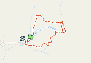

Length
6.1 km

Max alt
766 m

Uphill gradient
210 m
Km-Effort
8.9 km

Min alt
623 m

Downhill gradient
211 m
Boucle
Yes
Creation date :
2014-12-10 00:00:00.0
Updated on :
2014-12-10 00:00:00.0
3h30
Difficulty : Easy

FREE GPS app for hiking
 SityTrail
IGN / Geographical institutes
SityTrail World
The world is yours!
About
Trail Walking of 6.1 km to be discovered at Northern Territory, Macdonnell Region. This trail is proposed by trotetr.
Positioning
Country:
Australia
Region :
Northern Territory
Department/Province :
Macdonnell Region
Municipality :
Unknown
Location:
Unknown
Start:(Dec)
Start:(UTM)
761053 ; 7315116 (52J) S.
Comments
Trails nearby