Trail Walking Moret-Loing-et-Orvanne - 120822-GLM - Moret-MtAiveu - Photo
 randodan
randodan

User

© OpenStreetMap contributors
Length
Length
11.5 km
Max alt
Max alt
134 m
Uphill gradient
Uphill gradient
134 m
Km-Effort
Km-Effort  
13.3 km
Min alt
Min alt
75 m
Downhill gradient
Downhill gradient
137 m
Boucle
Boucle
Yes
Creation date :
2014-12-10 00:00:00.0
Updated on :
2014-12-10 00:00:00.0

(0 Reviews)

Walking
Walking
3h29
Difficulty : Easy

Scan this QR Code to open this trail in the SityTrail application

FREE GPS app for hiking

Logo SityTrail SityTrail

IGN / Geographical institutes

Download SityTrail from the App Store Download SityTrail from Google Play

Logo SityTrail SityTrail World

The world is yours!

Download SityTrail from the App Store Download SityTrail from Google Play Download SityTrail on Huawei AppGallery

About

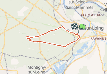
Trail Walking of 11.5 km to be discovered at Ile-de-France, Seine-et-Marne, Moret-Loing-et-Orvanne. This trail is proposed by randodan.

Description

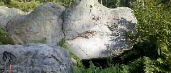
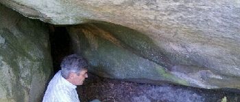
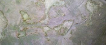
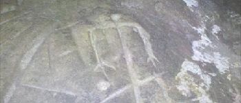
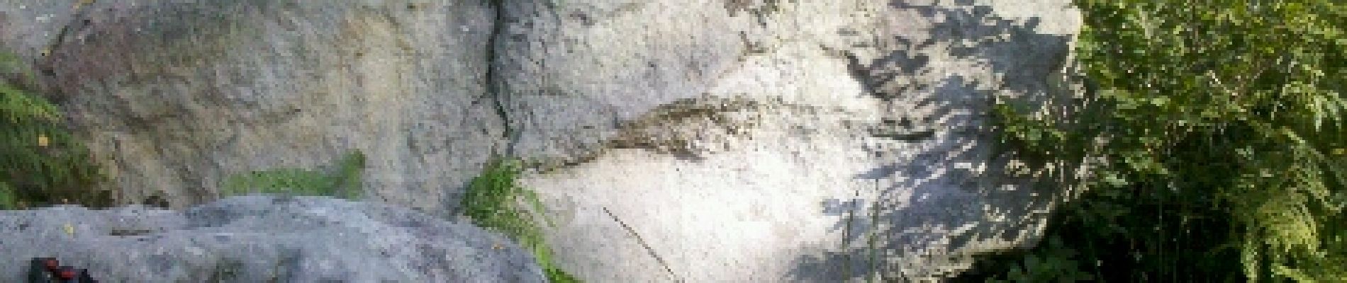
Mercredi matin . Une 1ère dès le départ : joignons le souterrain par le long de la nationale . L'abri orné au N.O. du Mont Aiveu . La mare, habitée par un "pas-là-pas-là" , RTT dans les hautes fougères , pause aux gravures rupestres du versant Sud . Retour Gros Bois tout droit . 7 participants .
         

Elevation profile

Photos

Points of interest

Point of interest Fontainebleau - Abri orné N.O. Mont Aiveu - Photo
randodan
Point of interest Fontainebleau - Gravures rupestres, sud Mont Aiveu - Photo
randodan
Point of interest Fontainebleau - Gravures rupestres Mont Aiveu - cervidé - Photo
randodan
Point of interest Fontainebleau - Gravure humanoïde N.O. Mont Aiveu - Photo
randodan

Positioning

Country:
France
Region :
Ile-de-France
Department/Province :
Seine-et-Marne
Municipality :
Moret-Loing-et-Orvanne
Location:
Moret-sur-Loing
Start:(UTM)
485617 ; 5357272 (31U) N.

Trails nearby

Trail Walking Champagne-sur-Seine - GLM-150507 - Champagne - Photo
Walking
randodan

Walking

Easy
(1)
Champagne-sur-Seine, Ile-de-France, Seine-et-Marne, France
17.3 km | 20 km-effort
4h 20min
Yes
Trail Walking Fontainebleau - Boucle 30 km Veni Venelles Vici - Photo
Walking
GUIDE
chessyca

Walking

Very difficult
(1)
Fontainebleau, Ile-de-France, Seine-et-Marne, France
30 km | 35 km-effort
6h 0min
No
Trail Walking Fontainebleau - viennes carosses - Photo
Walking
Yannick.Boireau

Walking

Very easy
(2)
Fontainebleau, Ile-de-France, Seine-et-Marne, France
10.8 km | 14 km-effort
2h 50min
Yes
Trail Walking Champagne-sur-Seine - Boucle Champagne/ Seine - Moret - St Mammes - Thomery - Photo
Walking
GUIDE
chessyca

Walking

Easy
Champagne-sur-Seine, Ile-de-France, Seine-et-Marne, France
24 km | 27 km-effort
5h 15min
Yes
Trail On foot Moret-Loing-et-Orvanne - La basse vallée du Lunain version 30 km - Photo
On foot
GUIDE
chessyca

On foot

Difficult
Moret-Loing-et-Orvanne, Ile-de-France, Seine-et-Marne, France
30 km | 34 km-effort
7h 39min
Yes
Trail On foot Fontainebleau - Sur les traces de Rosa Bonheur - Thomery - Photo
On foot
GUIDE
chessyca

On foot

Medium
Fontainebleau, Ile-de-France, Seine-et-Marne, France
30 km | 35 km-effort
7h 53min
Yes
Trail On foot Fontainebleau - Fontainebleau - Moret - Montigny - Photo
On foot
GUIDE
chessyca

On foot

Medium
Fontainebleau, Ile-de-France, Seine-et-Marne, France
30 km | 35 km-effort
7h 55min
Yes
Trail On foot Saint-Mammès - Batellerie et foret - Photo
On foot
GUIDE+

On foot

Easy
(1)
Saint-Mammès, Ile-de-France, Seine-et-Marne, France
8.6 km | 9.9 km-effort
2h 14min
Yes
Trail On foot Montigny-sur-Loing - De Kosciusko à Croc Marin - Photo
On foot
GUIDE+

On foot

Medium
Montigny-sur-Loing, Ile-de-France, Seine-et-Marne, France
17.5 km | 21 km-effort
4h 42min
Yes


Close
My subscriptions