![](/images/other/stat-length.png)
![Trail Mountain bike Les Martres-d'Artière - Pont du Chateau - Dallet - Photo](https://media.geolcdn.com/t/1900/400/ext.pjpeg?maxdim=2&url=https%3A%2F%2Fstatic1.geolcdn.com%2Fsiteimages%2Fupload%2Ffiles%2F1524743154velo.jpg)
Pont du Chateau - Dallet
sandchar
User
![Length](/images/other/stat-length.png)
Length
23 km
![Max alt](https://static1.geolcdn.com/siteimages/upload/files/1508320355ic_sort_altitude_max_24dp.png)
Max alt
366 m
![Uphill gradient](https://static1.geolcdn.com/siteimages/upload/files/1508320355ic_sort_den_pos_24dp.png)
Uphill gradient
210 m
![Km-Effort](/images/other/stat-length.png)
Km-Effort
26 km
![Min alt](https://static1.geolcdn.com/siteimages/upload/files/1508320355ic_sort_altitude_min_24dp.png)
Min alt
304 m
![Downhill gradient](https://static1.geolcdn.com/siteimages/upload/files/1508320355ic_sort_den_neg_24dp.png)
Downhill gradient
210 m
![Boucle](https://static1.geolcdn.com/siteimages/upload/files/16400158638029165_repeat_loop_refresh_sync_direction_icon.png)
Boucle
Yes
Creation date :
2014-12-10 00:00:00.0
Updated on :
2014-12-10 00:00:00.0
![Mountain bike](https://static1.geolcdn.com/sitytour/trail-icons/202.png)
1h31
Difficulty : Very easy
![Scan this QR Code to open this trail in the SityTrail application](https://capi.geolives.com/qq0zvz2zws4bq2lad0pu/sitytour/trails/147071/qr.png?size=200)
FREE GPS app for hiking
About
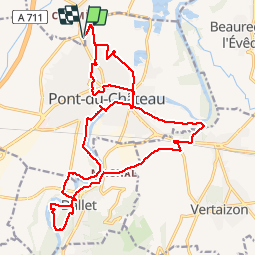
Trail Mountain bike of 23 km to be discovered at Auvergne-Rhône-Alpes, Puy-de-Dôme, Les Martres-d'Artière. This trail is proposed by sandchar.
Description
Rando agréable et très facile. Départ de cormède puis pont du Chateau, chicles, daller et retour a cormède.
Positioning
Country:
France
Region :
Auvergne-Rhône-Alpes
Department/Province :
Puy-de-Dôme
Municipality :
Les Martres-d'Artière
Location:
Unknown
Start:(Dec)
Start:(UTM)
518740 ; 5073144 (31T) N.
Comments
Trails nearby
![Walking Walking](https://static1.geolcdn.com/sitytour/trail-icons/101.png)
Beauregard_St_Aventin
Walking
Easy
(1)
Beauregard-l'Évêque,
Auvergne-Rhône-Alpes,
Puy-de-Dôme,
France
![](/images/other/stat-length.png)
8.7 km | 10.5 km-effort
2h 30min
![](https://static1.geolcdn.com/siteimages/upload/files/16400158638029165_repeat_loop_refresh_sync_direction_icon.png)
Yes
![Trail On foot Beauregard-l'Évêque - La Chapelle Saint-Aventin - Photo](https://media.geolcdn.com/t/375/260/717f30bf-5a07-430d-b59e-ecc0270b402e.jpeg&format=jpg&maxdim=2)
![On foot On foot](https://static1.geolcdn.com/sitytour/trail-icons/100.png)
La Chapelle Saint-Aventin
On foot
Easy
Beauregard-l'Évêque,
Auvergne-Rhône-Alpes,
Puy-de-Dôme,
France
![](/images/other/stat-length.png)
8.8 km | 10.6 km-effort
2h 24min
![](https://static1.geolcdn.com/siteimages/upload/files/16400158638029165_repeat_loop_refresh_sync_direction_icon.png)
Yes
![Trail On foot Pont-du-Château - Le Chemin des Batteliers - Photo](https://media.geolcdn.com/t/375/260/637fc0b7-6f7b-4d79-bd2a-b9e0ef453060.jpeg&format=jpg&maxdim=2)
![On foot On foot](https://static1.geolcdn.com/sitytour/trail-icons/100.png)
Le Chemin des Batteliers
On foot
Easy
Pont-du-Château,
Auvergne-Rhône-Alpes,
Puy-de-Dôme,
France
![](/images/other/stat-length.png)
4 km | 5 km-effort
1h 7min
![](https://static1.geolcdn.com/siteimages/upload/files/16400158638029165_repeat_loop_refresh_sync_direction_icon.png)
Yes
![Trail On foot Pont-du-Château - De Marchal a Cortal - Photo](https://media.geolcdn.com/t/375/260/0d71d93f-0494-4f38-8dbd-186ec2593344.jpeg&format=jpg&maxdim=2)
![On foot On foot](https://static1.geolcdn.com/sitytour/trail-icons/100.png)
De Marchal a Cortal
On foot
Easy
Pont-du-Château,
Auvergne-Rhône-Alpes,
Puy-de-Dôme,
France
![](/images/other/stat-length.png)
5.8 km | 6.7 km-effort
1h 31min
![](https://static1.geolcdn.com/siteimages/upload/files/16400158638029165_repeat_loop_refresh_sync_direction_icon.png)
Yes
![Trail Mountain bike Pont-du-Château - La Tonytruante - Pont du Château - Photo](https://media.geolcdn.com/t/375/260/ext.jpg?maxdim=2&url=https%3A%2F%2Fstatic1.geolcdn.com%2Fsiteimages%2Fupload%2Ffiles%2F1524743154velo.jpg)
![Mountain bike Mountain bike](https://static1.geolcdn.com/sitytour/trail-icons/202.png)
La Tonytruante - Pont du Château
Mountain bike
Medium
(1)
Pont-du-Château,
Auvergne-Rhône-Alpes,
Puy-de-Dôme,
France
![](/images/other/stat-length.png)
47 km | 58 km-effort
2h 30min
![](https://static1.geolcdn.com/siteimages/upload/files/16400158638029165_repeat_loop_refresh_sync_direction_icon.png)
Yes
![Trail Walking Pont-du-Château - Pont_Chateau_Machal_Cortal - Photo](https://media.geolcdn.com/t/375/260/c761f57c-ec00-4765-845e-a92cde5d76f7.jpg&format=jpg&maxdim=2)
![Walking Walking](https://static1.geolcdn.com/sitytour/trail-icons/101.png)
Pont_Chateau_Machal_Cortal
Walking
Easy
Pont-du-Château,
Auvergne-Rhône-Alpes,
Puy-de-Dôme,
France
![](/images/other/stat-length.png)
6.8 km | 7.8 km-effort
2h 0min
![](https://static1.geolcdn.com/siteimages/upload/files/16400158638029165_repeat_loop_refresh_sync_direction_icon.png)
Yes
![Trail Walking Vertaizon - Tour du puy de Mur_T - Photo](https://media.geolcdn.com/t/375/260/68117799-c52e-4e62-ba7d-433e43b465e5.jpg&format=jpg&maxdim=2)
![Walking Walking](https://static1.geolcdn.com/sitytour/trail-icons/101.png)
Tour du puy de Mur_T
Walking
Medium
Vertaizon,
Auvergne-Rhône-Alpes,
Puy-de-Dôme,
France
![](/images/other/stat-length.png)
13.9 km | 21 km-effort
3h 56min
![](https://static1.geolcdn.com/siteimages/upload/files/16400158638029165_repeat_loop_refresh_sync_direction_icon.png)
Yes
![Trail Walking Vertaizon - Vertaizon_Puy_de_Mur_1 - Photo](https://media.geolcdn.com/t/375/260/6b6caab7-f3a6-441a-8ae1-03600f1a4551.jpg&format=jpg&maxdim=2)
![Walking Walking](https://static1.geolcdn.com/sitytour/trail-icons/101.png)
Vertaizon_Puy_de_Mur_1
Walking
Difficult
Vertaizon,
Auvergne-Rhône-Alpes,
Puy-de-Dôme,
France
![](/images/other/stat-length.png)
13.7 km | 21 km-effort
4h 0min
![](https://static1.geolcdn.com/siteimages/upload/files/16400158638029165_repeat_loop_refresh_sync_direction_icon.png)
Yes
![Trail Mountain bike Pont-du-Château - RANDO VTT LANGLOIS - Photo](https://media.geolcdn.com/t/375/260/ext.jpg?maxdim=2&url=https%3A%2F%2Fstatic1.geolcdn.com%2Fsiteimages%2Fupload%2Ffiles%2F1524743154velo.jpg)
![Mountain bike Mountain bike](https://static1.geolcdn.com/sitytour/trail-icons/202.png)
RANDO VTT LANGLOIS
Mountain bike
Easy
(2)
Pont-du-Château,
Auvergne-Rhône-Alpes,
Puy-de-Dôme,
France
![](/images/other/stat-length.png)
30 km | 34 km-effort
2h 0min
![](https://static1.geolcdn.com/siteimages/upload/files/16400158638029165_repeat_loop_refresh_sync_direction_icon.png)
Yes