Trail Other activity Courmayeur - GR TMB 06 - Photo
 mazelpat
mazelpat

User

© OpenStreetMap contributors
Length
Length
16.7 km
Max alt
Max alt
2537 m
Uphill gradient
Uphill gradient
665 m
Km-Effort
Km-Effort  
29 km
Min alt
Min alt
1185 m
Downhill gradient
Downhill gradient
1545 m
Boucle
Boucle
No
Creation date :
2016-03-09 00:00:00.0
Updated on :
2016-03-09 00:00:00.0

(0 Reviews)

Other activity
Other activity
--
Difficulty : Unknown

Scan this QR Code to open this trail in the SityTrail application

FREE GPS app for hiking

Logo SityTrail SityTrail

IGN / Geographical institutes

Download SityTrail from the App Store Download SityTrail from Google Play

Logo SityTrail SityTrail World

The world is yours!

Download SityTrail from the App Store Download SityTrail from Google Play Download SityTrail on Huawei AppGallery

About

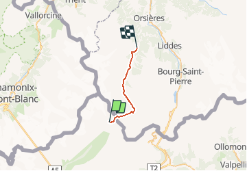
Trail Other activity of 16.7 km to be discovered at Aosta Valley, Unknown, Courmayeur. This trail is proposed by mazelpat.

Description

Etape 6 : Refuge Elena - Praz de fort

Elevation profile

Positioning

Country:
Italy
Region :
Aosta Valley
Department/Province :
Unknown
Municipality :
Courmayeur
Location:
Unknown
Start:(UTM)
349990 ; 5083098 (32T) N.

Trails nearby

Trail On foot Courmayeur - Alta Via n. 1 della Valle d'Aosta - Tappa 17 - Photo
On foot
GUIDE+

On foot

Easy
Courmayeur, Aosta Valley, Unknown, Italy
11.9 km | 18.2 km-effort
4h 8min
No
Trail On foot Courmayeur - (SI F09) Rifugio Bonatti - Rifugio Frassati - Photo
On foot
GUIDE+

On foot

Easy
Courmayeur, Aosta Valley, Unknown, Italy
7.5 km | 17.6 km-effort
4h 0min
No
Trail On foot Orsières - Sentier des Bergers - Photo
On foot
GUIDE+

On foot

Easy
Orsières, Valais/Wallis, Entremont, Switzerland
4.8 km | 9.2 km-effort
2h 5min
No
Trail On foot Courmayeur - Itinerario 23 Rifugio Dalmazzi - Photo
On foot
GUIDE+

On foot

Easy
Courmayeur, Aosta Valley, Unknown, Italy
4.1 km | 6.6 km-effort
1h 29min
No
Trail Walking Courmayeur - TMB J4 Ref.ELENA - COURMAYEUR - Photo
Walking
GerardBouche

Walking

Medium
Courmayeur, Aosta Valley, Unknown, Italy
13.5 km | 22 km-effort
4h 18min
No
Trail Walking Courmayeur - TMB day 4 - Photo
Walking
elixpomatia

Walking

Medium
Courmayeur, Aosta Valley, Unknown, Italy
16.6 km | 27 km-effort
5h 37min
No
Trail Walking Orsières - fully  - Photo
Walking
suzanne.bron

Walking

Easy
Orsières, Valais/Wallis, Entremont, Switzerland
3.8 km | 4.9 km-effort
1h 19min
No
Trail Walking Courmayeur - TMB6 AN - Photo
Walking
reneperrin

Walking

Easy
Courmayeur, Aosta Valley, Unknown, Italy
12.6 km | 21 km-effort
4h 5min
No
Trail Walking Orsières - TMB Étape 5 : Gite de La Peule au Relais d'Arpette - Photo
Walking
Timothée ZARAGORI

Walking

Very difficult
Orsières, Valais/Wallis, Entremont, Switzerland
22 km | 34 km-effort
7h 40min
No


Close
My subscriptions