Trail Running La Chapelle-en-Valgaudémar - lacs de Petarel  - Photo
 lolosese
lolosese

User

© OpenStreetMap contributors
Length
Length
20 km
Max alt
Max alt
2464 m
Uphill gradient
Uphill gradient
1431 m
Km-Effort
Km-Effort  
40 km
Min alt
Min alt
1085 m
Downhill gradient
Downhill gradient
1438 m
Boucle
Boucle
No
Creation date :
2014-12-10 00:00:00.0
Updated on :
2014-12-10 00:00:00.0

(0 Reviews)

Running
Running
5h40
Difficulty : Medium

Scan this QR Code to open this trail in the SityTrail application

FREE GPS app for hiking

Logo SityTrail SityTrail

IGN / Geographical institutes

Download SityTrail from the App Store Download SityTrail from Google Play

Logo SityTrail SityTrail World

The world is yours!

Download SityTrail from the App Store Download SityTrail from Google Play Download SityTrail on Huawei AppGallery

About

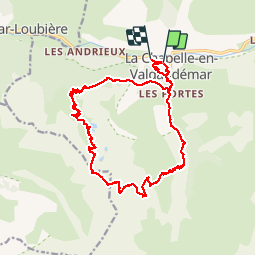
Trail Running of 20 km to be discovered at Provence-Alpes-Côte d'Azur, Hautes-Alpes, La Chapelle-en-Valgaudémar. This trail is proposed by lolosese.

Description

à partir de la Chapelle en Valgaudemar - randonnée / course

Elevation profile

Photos

Points of interest

Point of interest La Chapelle-en-Valgaudémar - Point de vue vers le sommet - Photo
lolosese
LA CHAPELLE-EN-VALGAUDÉMAR 
Point of interest La Chapelle-en-Valgaudémar - 1er lac (petit) - Photo
lolosese
LA CHAPELLE-EN-VALGAUDÉMAR 
Point of interest La Chapelle-en-Valgaudémar - 2ème lac - Photo
lolosese
LA CHAPELLE-EN-VALGAUDÉMAR 

Positioning

Country:
France
Region :
Provence-Alpes-Côte d'Azur
Department/Province :
Hautes-Alpes
Municipality :
La Chapelle-en-Valgaudémar
Location:
Unknown
Start:(UTM)
278101 ; 4966534 (32T) N.

Trails nearby

Trail Walking La Chapelle-en-Valgaudémar - circuit de la cabane de l'aup .08-06-14 - Photo
Walking
Dervalmarc

Walking

Very easy
(1)
La Chapelle-en-Valgaudémar, Provence-Alpes-Côte d'Azur, Hautes-Alpes, France
8.8 km | 13.6 km-effort
2h 37min
Yes
Trail Walking La Chapelle-en-Valgaudémar - Tour du Vieux Chaillol 2/5 - Du Gîte Le Casset au Refuge de Vallonpierre - Photo
Walking
tracegps

Walking

Medium
(1)
La Chapelle-en-Valgaudémar, Provence-Alpes-Côte d'Azur, Hautes-Alpes, France
11.8 km | 24 km-effort
4h 30min
No
Trail Walking Villar-Loubière - Pic Turbat - Photo
Walking
GUIDE
Marco05

Walking

Very difficult
Villar-Loubière, Provence-Alpes-Côte d'Azur, Hautes-Alpes, France
19.8 km | 46 km-effort
10h 26min
Yes
Trail Walking La Chapelle-en-Valgaudémar - Lacs de Pétarel-Col de la Béranne - Photo
Walking
GUIDE
Marco05

Walking

Medium
La Chapelle-en-Valgaudémar, Provence-Alpes-Côte d'Azur, Hautes-Alpes, France
11.1 km | 23 km-effort
7h 0min
Yes
Trail Walking La Chapelle-en-Valgaudémar - Pas de l'Olan - Photo
Walking
GUIDE
Marco05

Walking

Very difficult
La Chapelle-en-Valgaudémar, Provence-Alpes-Côte d'Azur, Hautes-Alpes, France
12.6 km | 34 km-effort
7h 37min
Yes
Trail Walking La Chapelle-en-Valgaudémar - Valgaudemar - La Chapelle (les Portes) forêt - 4.3km 285m 1h35 - 2018 07 05 - public - Photo
Walking
GUIDE
Orcal37

Walking

Easy
La Chapelle-en-Valgaudémar, Provence-Alpes-Côte d'Azur, Hautes-Alpes, France
4.3 km | 8.1 km-effort
1h 40min
Yes
Trail Walking La Chapelle-en-Valgaudémar - Valgaudemar - La Chapelle Vallon de la Navette - 10.9km 420m 3h25 - 2018 06 30 - public - Photo
Walking
GUIDE
Orcal37

Walking

Medium
La Chapelle-en-Valgaudémar, Provence-Alpes-Côte d'Azur, Hautes-Alpes, France
10.9 km | 16.4 km-effort
4h 30min
Yes
Trail Walking La Chapelle-en-Valgaudémar - Valgaudemar - La Chapelle Vallée de la Séveraisse Refuge du Clot - 15.9km 450m 4h35 - 2018 07 01 - public - Photo
Walking
GUIDE
Orcal37

Walking

Medium
La Chapelle-en-Valgaudémar, Provence-Alpes-Côte d'Azur, Hautes-Alpes, France
15.9 km | 22 km-effort
5h 55min
Yes
Trail Walking La Chapelle-en-Valgaudémar - Les Portes , Les cascades. - Photo
Walking
sereton

Walking

Medium
La Chapelle-en-Valgaudémar, Provence-Alpes-Côte d'Azur, Hautes-Alpes, France
8.1 km | 11 km-effort
2h 25min
Yes


Close
My subscriptions