Trail Walking Jouy-en-Josas - jouy, st cyr, versailles chateau, jouy - Photo

jouy, st cyr, versailles chateau, jouy

 rico21
rico21

User

© OpenStreetMap contributors
Length
Length
28 km
Max alt
Max alt
187 m
Uphill gradient
Uphill gradient
385 m
Km-Effort
Km-Effort  
33 km
Min alt
Min alt
89 m
Downhill gradient
Downhill gradient
385 m
Boucle
Boucle
Yes
Creation date :
2014-12-10 00:00:00.0
Updated on :
2014-12-10 00:00:00.0

(0 Reviews)

Walking
Walking
--
Difficulty : Easy

Scan this QR Code to open this trail in the SityTrail application

FREE GPS app for hiking

Logo SityTrail SityTrail

IGN / Geographical institutes

Download SityTrail from the App Store Download SityTrail from Google Play

Logo SityTrail SityTrail World

The world is yours!

Download SityTrail from the App Store Download SityTrail from Google Play Download SityTrail on Huawei AppGallery

About

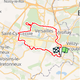
Trail Walking of 28 km to be discovered at Ile-de-France, Yvelines, Jouy-en-Josas. This trail is proposed by rico21.

Description

prendre le RER C jusqu’à JOUY EN JOSAS,
suivre la vallée de la bièvre, rejoindre la gare de st Cyr,    
aller jusqu’à la première entrée du château sur N10 faire le tour du grand canal jusqu'au Trianon
Prendre la porte de la reine et la route de la reine, rue de la république, et rejoindre l'octroi
traverser Prochefontaine jusqu’à A86
Traverser l'A86 a hauteur de Velizy quartier Mozard
Traverser le bois des Metz et redescendre au centre ville de Jouy

Elevation profile

Positioning

Country:
France
Region :
Ile-de-France
Department/Province :
Yvelines
Municipality :
Jouy-en-Josas
Location:
Unknown
Start:(UTM)
438513 ; 5401686 (31U) N.

Trails nearby

Trail Walking Chaville - Le Sentier des 7 étangs - Photo
Walking
tracegps

Walking

Difficult
(5)
Chaville, Ile-de-France, Hauts-de-Seine, France
23 km | 31 km-effort
5h 0min
Yes
Trail Walking Jouy-en-Josas - GRP CV-IDF 2023 - Photo
Walking
clalaur

Walking

Difficult
(1)
Jouy-en-Josas, Ile-de-France, Yvelines, France
11.2 km | 14.5 km-effort
3h 17min
No
Trail Walking Bièvres - De Bièvres à Antony - Photo
Walking
tracegps

Walking

Medium
(1)
Bièvres, Ile-de-France, Essonne, France
11.9 km | 14 km-effort
3h 0min
No
Trail Walking Jouy-en-Josas - ferme viltain - Photo
Walking
papoune69

Walking

Very easy
(2)
Jouy-en-Josas, Ile-de-France, Yvelines, France
9 km | 10.1 km-effort
2h 13min
Yes
Trail Walking Viroflay - Les 3 Forêts; Meudon, Fausses Reposes et Versailles - Photo
Walking
tracegps

Walking

Difficult
(2)
Viroflay, Ile-de-France, Yvelines, France
25 km | 32 km-effort
5h 19min
Yes
Trail Walking Chaville - Sentier des deux Forêts - Meudon et Verrières - Photo
Walking
tracegps

Walking

Difficult
(2)
Chaville, Ile-de-France, Hauts-de-Seine, France
23 km | 29 km-effort
5h 0min
Yes
Trail Walking Buc - Le Tour de Satory - Photo
Walking
tracegps

Walking

Difficult
(2)
Buc, Ile-de-France, Yvelines, France
23 km | 28 km-effort
4h 49min
Yes
Trail Walking Bièvres - Autour de Bièvres - Photo
Walking
tracegps

Walking

Medium
(4)
Bièvres, Ile-de-France, Essonne, France
7.6 km | 9.4 km-effort
2h 30min
Yes
Trail Walking Versailles - 20240828_100557 - Photo
Walking
GUIDE
chessyca

Walking

Very difficult
Versailles, Ile-de-France, Yvelines, France
19.7 km | 25 km-effort
5h 34min
Yes


Close
My subscriptions