![](/images/other/stat-length.png)
![Trail Walking Moret-Loing-et-Orvanne - 120801-GLM - Moret-EtangsMassesParault - Photo](https://media.geolcdn.com/t/1900/400/ext.pjpeg?maxdim=2&url=https%3A%2F%2Fservices.sitytrail.com%2FGeolivesWS%2FDownloadMedia.ashx%3FTrailID%3D143250%26Media%3D20120801101745.jpeg)
120801-GLM - Moret-EtangsMassesParault
randodan
User
![Length](/images/other/stat-length.png)
Length
9.7 km
![Max alt](https://static1.geolcdn.com/siteimages/upload/files/1508320355ic_sort_altitude_max_24dp.png)
Max alt
102 m
![Uphill gradient](https://static1.geolcdn.com/siteimages/upload/files/1508320355ic_sort_den_pos_24dp.png)
Uphill gradient
94 m
![Km-Effort](/images/other/stat-length.png)
Km-Effort
11 km
![Min alt](https://static1.geolcdn.com/siteimages/upload/files/1508320355ic_sort_altitude_min_24dp.png)
Min alt
45 m
![Downhill gradient](https://static1.geolcdn.com/siteimages/upload/files/1508320355ic_sort_den_neg_24dp.png)
Downhill gradient
100 m
![Boucle](https://static1.geolcdn.com/siteimages/upload/files/16400158638029165_repeat_loop_refresh_sync_direction_icon.png)
Boucle
Yes
Creation date :
2014-12-10 00:00:00.0
Updated on :
2014-12-10 00:00:00.0
![Walking](https://static1.geolcdn.com/sitytour/trail-icons/101.png)
2h44
Difficulty : Very easy
![Scan this QR Code to open this trail in the SityTrail application](https://capi.geolives.com/qq0zvz2zws4bq2lad0pu/sitytour/trails/143250/qr.png?size=200)
FREE GPS app for hiking
About
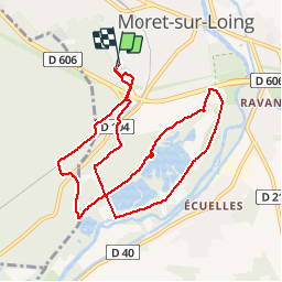
Trail Walking of 9.7 km to be discovered at Ile-de-France, Seine-et-Marne, Moret-Loing-et-Orvanne. This trail is proposed by randodan.
Description
Mercredi matin . Jean nous emmène faire le tour des Étangs des Masses Parault . Départ sentier dans les hautes herbes vers le circuit du Cygne , tour des Étangs , retour par la M.F. de Gros Bois . 11h20 aux voitures .
7 participants.
Positioning
Country:
France
Region :
Ile-de-France
Department/Province :
Seine-et-Marne
Municipality :
Moret-Loing-et-Orvanne
Location:
Moret-sur-Loing
Start:(Dec)
Start:(UTM)
485582 ; 5357225 (31U) N.
Comments
Trails nearby
![Trail Walking Champagne-sur-Seine - GLM-150507 - Champagne - Photo](https://media.geolcdn.com/t/375/260/ext.jpg?maxdim=2&url=https%3A%2F%2Fservices.sitytrail.com%2FGeolivesWS%2FDownloadMedia.ashx%3FTrailID%3D417747%26Media%3Dcf3441e3-cd65-4b43-a868-e5ea57f18914.jpg)
![Walking Walking](https://static1.geolcdn.com/sitytour/trail-icons/101.png)
GLM-150507 - Champagne
Walking
Easy
(1)
Champagne-sur-Seine,
Ile-de-France,
Seine-et-Marne,
France
![](/images/other/stat-length.png)
17.3 km | 20 km-effort
4h 20min
![](https://static1.geolcdn.com/siteimages/upload/files/16400158638029165_repeat_loop_refresh_sync_direction_icon.png)
Yes
![Trail Walking Fontainebleau - viennes carosses - Photo](https://media.geolcdn.com/t/375/260/ext.jpg?maxdim=2&url=https%3A%2F%2Fmedia.geolcdn.com%2Ff%2F9b54e644-4214-4411-b7b4-ea5a49e11005.jpg)
![Walking Walking](https://static1.geolcdn.com/sitytour/trail-icons/101.png)
viennes carosses
Walking
Very easy
(2)
Fontainebleau,
Ile-de-France,
Seine-et-Marne,
France
![](/images/other/stat-length.png)
10.8 km | 14 km-effort
2h 50min
![](https://static1.geolcdn.com/siteimages/upload/files/16400158638029165_repeat_loop_refresh_sync_direction_icon.png)
Yes
![Trail On foot Saint-Mammès - Batellerie et foret - Photo](https://media.geolcdn.com/t/375/260/ext.jpg?maxdim=2&url=https%3A%2F%2Fmedia.geolcdn.com%2Ff%2F51b649c2-1598-47b6-9a5e-d0492e6f7a35.jpeg)
![On foot On foot](https://static1.geolcdn.com/sitytour/trail-icons/100.png)
Batellerie et foret
On foot
Easy
Saint-Mammès,
Ile-de-France,
Seine-et-Marne,
France
![](/images/other/stat-length.png)
8.6 km | 9.9 km-effort
2h 14min
![](https://static1.geolcdn.com/siteimages/upload/files/16400158638029165_repeat_loop_refresh_sync_direction_icon.png)
Yes
![Trail On foot Montigny-sur-Loing - De Kosciusko à Croc Marin - Photo](https://media.geolcdn.com/t/375/260/ext.jpg?maxdim=2&url=https%3A%2F%2Fmedia.geolcdn.com%2Ff%2Ff5bc045f-e010-4cc1-a4ef-a06cb0f8d565.jpeg)
![On foot On foot](https://static1.geolcdn.com/sitytour/trail-icons/100.png)
De Kosciusko à Croc Marin
On foot
Medium
Montigny-sur-Loing,
Ile-de-France,
Seine-et-Marne,
France
![](/images/other/stat-length.png)
17.5 km | 21 km-effort
4h 42min
![](https://static1.geolcdn.com/siteimages/upload/files/16400158638029165_repeat_loop_refresh_sync_direction_icon.png)
Yes
![Trail On foot Moret-Loing-et-Orvanne - FR-PR 9 - Photo](https://media.geolcdn.com/t/375/260/ext.jpg?maxdim=2&url=https%3A%2F%2Fmedia.geolcdn.com%2Ff%2F1bc3aed3-626a-45b7-9c5f-13d7fffcd74b.jpeg)
![On foot On foot](https://static1.geolcdn.com/sitytour/trail-icons/100.png)
FR-PR 9
On foot
Easy
Moret-Loing-et-Orvanne,
Ile-de-France,
Seine-et-Marne,
France
![](/images/other/stat-length.png)
5 km | 6 km-effort
1h 22min
![](https://static1.geolcdn.com/siteimages/upload/files/16400158638029165_repeat_loop_refresh_sync_direction_icon.png)
No
![Trail On foot Moret-Loing-et-Orvanne - Entre Loing et Orvanne - Photo](https://media.geolcdn.com/t/375/260/ext.jpg?maxdim=2&url=https%3A%2F%2Fmedia.geolcdn.com%2Ff%2F03f6f91d-f2c6-4c29-98db-41cd58cd4804.jpeg)
![On foot On foot](https://static1.geolcdn.com/sitytour/trail-icons/100.png)
Entre Loing et Orvanne
On foot
Easy
Moret-Loing-et-Orvanne,
Ile-de-France,
Seine-et-Marne,
France
![](/images/other/stat-length.png)
12.8 km | 15.1 km-effort
3h 26min
![](https://static1.geolcdn.com/siteimages/upload/files/16400158638029165_repeat_loop_refresh_sync_direction_icon.png)
No
![Trail Walking Fontainebleau - Fontainebleau tour est - Photo](https://media.geolcdn.com/t/375/260/ext.jpg?maxdim=2&url=https%3A%2F%2Fstatic1.geolcdn.com%2Fsiteimages%2Fupload%2Ffiles%2F1553511878bg_sport_marche.png)
![Walking Walking](https://static1.geolcdn.com/sitytour/trail-icons/101.png)
Fontainebleau tour est
Walking
Difficult
(4)
Fontainebleau,
Ile-de-France,
Seine-et-Marne,
France
![](/images/other/stat-length.png)
22 km | 27 km-effort
6h 10min
![](https://static1.geolcdn.com/siteimages/upload/files/16400158638029165_repeat_loop_refresh_sync_direction_icon.png)
Yes
![Trail Walking Moret-Loing-et-Orvanne - RSL 011 - Photo](https://media.geolcdn.com/t/375/260/ext.jpg?maxdim=2&url=https%3A%2F%2Fstatic1.geolcdn.com%2Fsiteimages%2Fupload%2Ffiles%2F1553511878bg_sport_marche.png)
![Walking Walking](https://static1.geolcdn.com/sitytour/trail-icons/101.png)
RSL 011
Walking
Very easy
(1)
Moret-Loing-et-Orvanne,
Ile-de-France,
Seine-et-Marne,
France
![](/images/other/stat-length.png)
17.7 km | 20 km-effort
5h 0min
![](https://static1.geolcdn.com/siteimages/upload/files/16400158638029165_repeat_loop_refresh_sync_direction_icon.png)
Yes
![Trail Hybrid bike Moret-Loing-et-Orvanne - Musée Antoine Bourdelle - Photo](https://media.geolcdn.com/t/375/260/ext.jpg?maxdim=2&url=https%3A%2F%2Fmedia.geolcdn.com%2Ff%2F6ceefb99-314b-4005-9863-b58b9d239844.jpg)
![Hybrid bike Hybrid bike](https://static1.geolcdn.com/sitytour/trail-icons/203.png)
Musée Antoine Bourdelle
Hybrid bike
Very difficult
Moret-Loing-et-Orvanne,
Ile-de-France,
Seine-et-Marne,
France
![](/images/other/stat-length.png)
55 km | 61 km-effort
3h 44min
![](https://static1.geolcdn.com/siteimages/upload/files/16400158638029165_repeat_loop_refresh_sync_direction_icon.png)
No
SUR LE CHEMIN DU RETOUR nous avons croisé des bornes en pierre numérotés. savez vous ce que sait ??merci et rassuré vous aussi a salins les moustiques sont présents
Bcp de moustiques sur cette balade et très peu de vue directe sur le plan d eau. Mais sinon dans l ensemble sympathique !!