![](/images/other/stat-length.png)
![Trail Motor Bruges - Escapade en Charente 2012 - Photo](https://media.geolcdn.com/t/1900/400/ext.pjpeg?maxdim=2&url=https%3A%2F%2Fservices.sitytrail.com%2FGeolivesWS%2FDownloadMedia.ashx%3FTrailID%3D141858%26Media%3D52823fb7-1ddd-4b13-b35d-27ae7b597f4d.jpg)
Escapade en Charente 2012
roadflyer33
User
![Length](/images/other/stat-length.png)
Length
245 km
![Max alt](https://static1.geolcdn.com/siteimages/upload/files/1508320355ic_sort_altitude_max_24dp.png)
Max alt
172 m
![Uphill gradient](https://static1.geolcdn.com/siteimages/upload/files/1508320355ic_sort_den_pos_24dp.png)
Uphill gradient
2682 m
![Km-Effort](/images/other/stat-length.png)
Km-Effort
280 km
![Min alt](https://static1.geolcdn.com/siteimages/upload/files/1508320355ic_sort_altitude_min_24dp.png)
Min alt
-10 m
![Downhill gradient](https://static1.geolcdn.com/siteimages/upload/files/1508320355ic_sort_den_neg_24dp.png)
Downhill gradient
2682 m
![Boucle](https://static1.geolcdn.com/siteimages/upload/files/16400158638029165_repeat_loop_refresh_sync_direction_icon.png)
Boucle
Yes
Creation date :
2014-12-10 00:00:00.0
Updated on :
2014-12-10 00:00:00.0
![Motor](https://static1.geolcdn.com/sitytour/trail-icons/400.png)
--
Difficulty : Unknown
![Scan this QR Code to open this trail in the SityTrail application](https://capi.geolives.com/qq0zvz2zws4bq2lad0pu/sitytour/trails/141858/qr.png?size=200)
FREE GPS app for hiking
About
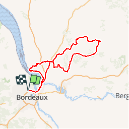
Trail Motor of 245 km to be discovered at New Aquitaine, Gironde, Bruges. This trail is proposed by roadflyer33.
Description
250 km sur petites routes, arret visite et pique-nique à Aubeterre, chateau de Chalais, circuit des hautes saintonges, puis retours par Bourg sur Gironde.
Positioning
Country:
France
Region :
New Aquitaine
Department/Province :
Gironde
Municipality :
Bruges
Location:
Unknown
Start:(Dec)
Start:(UTM)
688448 ; 4973460 (30T) N.
Comments
Trails nearby
![Trail Walking Blanquefort - Pnl Tanais - Photo](https://media.geolcdn.com/t/375/260/d5d98c98-c615-4cb3-9bf4-916690b17932.jpg&format=jpg&maxdim=2)
![Walking Walking](https://static1.geolcdn.com/sitytour/trail-icons/101.png)
Pnl Tanais
Walking
Medium
(1)
Blanquefort,
New Aquitaine,
Gironde,
France
![](/images/other/stat-length.png)
10.3 km | 11.4 km-effort
3h 55min
![](https://static1.geolcdn.com/siteimages/upload/files/16400158638029165_repeat_loop_refresh_sync_direction_icon.png)
Yes
![Trail Walking Blanquefort - Circuit autour de Blanquefort - Photo](https://media.geolcdn.com/t/375/260/e929d0b7-3df3-414f-8052-5790c33dbb56.jpg&format=jpg&maxdim=2)
![Walking Walking](https://static1.geolcdn.com/sitytour/trail-icons/101.png)
Circuit autour de Blanquefort
Walking
Difficult
Blanquefort,
New Aquitaine,
Gironde,
France
![](/images/other/stat-length.png)
12.4 km | 13.8 km-effort
3h 7min
![](https://static1.geolcdn.com/siteimages/upload/files/16400158638029165_repeat_loop_refresh_sync_direction_icon.png)
No
![Trail Walking Blanquefort - Blanquefort/ Le Pian-Medoc - Photo](https://media.geolcdn.com/t/375/260/661631f6-1335-49e9-a8c6-69d8a45a6939.jpg&format=jpg&maxdim=2)
![Walking Walking](https://static1.geolcdn.com/sitytour/trail-icons/101.png)
Blanquefort/ Le Pian-Medoc
Walking
Medium
Blanquefort,
New Aquitaine,
Gironde,
France
![](/images/other/stat-length.png)
14.6 km | 15.9 km-effort
4h 0min
![](https://static1.geolcdn.com/siteimages/upload/files/16400158638029165_repeat_loop_refresh_sync_direction_icon.png)
Yes
![Trail Walking Blanquefort - Tanais finalisé - Photo](https://media.geolcdn.com/t/375/260/65129eed-45b3-4fa6-9c6a-476d886a3a2f.jpg&format=jpg&maxdim=2)
![Walking Walking](https://static1.geolcdn.com/sitytour/trail-icons/101.png)
Tanais finalisé
Walking
Very easy
Blanquefort,
New Aquitaine,
Gironde,
France
![](/images/other/stat-length.png)
19.3 km | 21 km-effort
5h 24min
![](https://static1.geolcdn.com/siteimages/upload/files/16400158638029165_repeat_loop_refresh_sync_direction_icon.png)
Yes
![Trail Walking Bruges - JFT YB ETAPE 15 13-5-2014 - Photo](https://media.geolcdn.com/t/375/260/ext.jpg?maxdim=2&url=https%3A%2F%2Fservices.sitytrail.com%2FGeolivesWS%2FDownloadMedia.ashx%3FTrailID%3D301267%26Media%3Dfix__20140513144815.jpg)
![Walking Walking](https://static1.geolcdn.com/sitytour/trail-icons/101.png)
JFT YB ETAPE 15 13-5-2014
Walking
Easy
Bruges,
New Aquitaine,
Gironde,
France
![](/images/other/stat-length.png)
17.2 km | 18.7 km-effort
3h 55min
![](https://static1.geolcdn.com/siteimages/upload/files/16400158638029165_repeat_loop_refresh_sync_direction_icon.png)
No
![Trail Running Bordeaux - LORMONT CENNON LA BURTHE - Photo](https://media.geolcdn.com/t/375/260/ext.jpg?maxdim=2&url=https%3A%2F%2Fstatic1.geolcdn.com%2Fsiteimages%2Fupload%2Ffiles%2F1524743154running.jpg)
![Running Running](https://static1.geolcdn.com/sitytour/trail-icons/103.png)
LORMONT CENNON LA BURTHE
Running
Medium
(1)
Bordeaux,
New Aquitaine,
Gironde,
France
![](/images/other/stat-length.png)
34 km | 41 km-effort
Unknown
![](https://static1.geolcdn.com/siteimages/upload/files/16400158638029165_repeat_loop_refresh_sync_direction_icon.png)
Yes
![Trail Walking Le Taillan-Médoc - 2010-09-02 - 19h41m27 - Photo](https://media.geolcdn.com/t/375/260/ext.jpg?maxdim=2&url=https%3A%2F%2Fservices.sitytrail.com%2FGeolivesWS%2FDownloadMedia.ashx%3FTrailID%3D45181%26Media%3Dimage2.jpg)
![Walking Walking](https://static1.geolcdn.com/sitytour/trail-icons/101.png)
2010-09-02 - 19h41m27
Walking
Very easy
Le Taillan-Médoc,
New Aquitaine,
Gironde,
France
![](/images/other/stat-length.png)
8.5 km | 9.3 km-effort
Unknown
![](https://static1.geolcdn.com/siteimages/upload/files/16400158638029165_repeat_loop_refresh_sync_direction_icon.png)
Yes
![Trail Walking Bordeaux - bois de Bordeaux - Photo](https://media.geolcdn.com/t/375/260/841631d8-b851-4b94-8513-4c522c93b8e6.jpg&format=jpg&maxdim=2)
![Walking Walking](https://static1.geolcdn.com/sitytour/trail-icons/101.png)
bois de Bordeaux
Walking
Easy
Bordeaux,
New Aquitaine,
Gironde,
France
![](/images/other/stat-length.png)
3.5 km | 3.8 km-effort
1h 55min
![](https://static1.geolcdn.com/siteimages/upload/files/16400158638029165_repeat_loop_refresh_sync_direction_icon.png)
Yes
![Trail Walking Eysines - GR Bordeaux Métropole. EYSINES MAGUDAS. - Photo](https://media.geolcdn.com/t/375/260/91b4e53c-8028-4e29-8bf2-0ff221a4fcc2.jpeg&format=jpg&maxdim=2)
![Walking Walking](https://static1.geolcdn.com/sitytour/trail-icons/101.png)
GR Bordeaux Métropole. EYSINES MAGUDAS.
Walking
Very easy
Eysines,
New Aquitaine,
Gironde,
France
![](/images/other/stat-length.png)
16.1 km | 17.7 km-effort
3h 37min
![](https://static1.geolcdn.com/siteimages/upload/files/16400158638029165_repeat_loop_refresh_sync_direction_icon.png)
No