Trail Walking La Giettaz - La Vierge des Alpages - Photo
 biollay
biollay

User

© OpenStreetMap contributors
Length
Length
4.8 km
Max alt
Max alt
1879 m
Uphill gradient
Uphill gradient
571 m
Km-Effort
Km-Effort  
10.6 km
Min alt
Min alt
1302 m
Downhill gradient
Downhill gradient
13 m
Boucle
Boucle
No
Creation date :
2019-06-29 13:12:53.867
Updated on :
2019-06-29 13:12:54.372

(0 Reviews)

Walking
Walking
2h32
Difficulty : Medium

Scan this QR Code to open this trail in the SityTrail application

FREE GPS app for hiking

Logo SityTrail SityTrail

IGN / Geographical institutes

Download SityTrail from the App Store Download SityTrail from Google Play

Logo SityTrail SityTrail World

The world is yours!

Download SityTrail from the App Store Download SityTrail from Google Play Download SityTrail on Huawei AppGallery

About

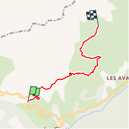
Trail Walking of 4.8 km to be discovered at Auvergne-Rhône-Alpes, Savoy, La Giettaz. This trail is proposed by biollay.

Description

Rando à pied sur les pentes sud de la Chaine des Aravis. En partie en forêt sur piste pastorale au début, puis un sentier vous mene jusqu'à la Vierge des Alpages. (doubler la distance pour le retour)

Elevation profile

Points of interest

Point of interest La Giettaz - Le Megevan - Photo
biollay
LA GIETTAZ 

Positioning

Country:
France
Region :
Auvergne-Rhône-Alpes
Department/Province :
Savoy
Municipality :
La Giettaz
Location:
Unknown
Start:(UTM)
304693 ; 5082664 (32T) N.

Comments

Please log in to post a review or rate the element


superbe randonnée accessible et tranquile, loin de la foule de certains parcs. face au Mont blanc une bonne partie de l'itinéraire.


Trails nearby

Trail Walking La Giettaz - Le Plan - col de Jaillet - Photo
Walking
wbarge

Walking

Medium
(2)
La Giettaz, Auvergne-Rhône-Alpes, Savoy, France
11.9 km | 19.7 km-effort
4h 18min
Yes
Trail Walking La Clusaz - Les Converses, Le Planet, Beauregard, les Corbassières (boucle) - Photo
Walking
GUIDE
lhomme.ph

Walking

Difficult
La Clusaz, Auvergne-Rhône-Alpes, Upper Savoy, France
10.4 km | 17.7 km-effort
3h 11min
Yes
Trail Walking La Giettaz - Boucle de Croisse Baulet - Photo
Walking
olivecoco

Walking

Medium
(1)
La Giettaz, Auvergne-Rhône-Alpes, Savoy, France
9.4 km | 23 km-effort
4h 2min
Yes
Trail Snowshoes La Clusaz - col aravis - Photo
Snowshoes
myjackotte

Snowshoes

Easy
(2)
La Clusaz, Auvergne-Rhône-Alpes, Upper Savoy, France
5.7 km | 8.2 km-effort
2h 16min
Yes
Trail Other activity La Giettaz - croise baulet - Photo
Other activity
twistss

Other activity

Very easy
(3)
La Giettaz, Auvergne-Rhône-Alpes, Savoy, France
12.1 km | 27 km-effort
3h 30min
Yes
Trail Mountain bike La Clusaz - VTT Aravis  - Photo
Mountain bike
Tibo74lc

Mountain bike

Medium
(1)
La Clusaz, Auvergne-Rhône-Alpes, Upper Savoy, France
35 km | 52 km-effort
2h 38min
Yes
Trail Mountain bike La Clusaz - Aravis  - Photo
Mountain bike
Tibo74lc

Mountain bike

Very easy
(1)
La Clusaz, Auvergne-Rhône-Alpes, Upper Savoy, France
43 km | 63 km-effort
3h 46min
Yes
Trail Walking Saint-Nicolas-la-Chapelle - SAINT NICOLAS LA CHAPELLE - Photo
Walking
albertville

Walking

Very easy
(1)
Saint-Nicolas-la-Chapelle, Auvergne-Rhône-Alpes, Savoy, France
9.5 km | 16.8 km-effort
3h 41min
No
Trail Motor La Giettaz - La Giettaz - Col des Aravis - Photo
Motor
albertville

Motor

Very easy
(1)
La Giettaz, Auvergne-Rhône-Alpes, Savoy, France
15.8 km | 23 km-effort
58min
No


Close
My subscriptions