![](/images/other/stat-length.png)
![Trail Walking Saint-Maixme-Hauterive - Forêt et vallée de l''Avre - Photo](https://media.geolcdn.com/t/1900/400/ext.pjpeg?maxdim=2&url=https%3A%2F%2Fstatic1.geolcdn.com%2Fsiteimages%2Fupload%2Ffiles%2F1553511878bg_sport_marche.png)
Forêt et vallée de l''Avre
papymich28
User
![Length](/images/other/stat-length.png)
Length
20 km
![Max alt](https://static1.geolcdn.com/siteimages/upload/files/1508320355ic_sort_altitude_max_24dp.png)
Max alt
197 m
![Uphill gradient](https://static1.geolcdn.com/siteimages/upload/files/1508320355ic_sort_den_pos_24dp.png)
Uphill gradient
194 m
![Km-Effort](/images/other/stat-length.png)
Km-Effort
23 km
![Min alt](https://static1.geolcdn.com/siteimages/upload/files/1508320355ic_sort_altitude_min_24dp.png)
Min alt
130 m
![Downhill gradient](https://static1.geolcdn.com/siteimages/upload/files/1508320355ic_sort_den_neg_24dp.png)
Downhill gradient
190 m
![Boucle](https://static1.geolcdn.com/siteimages/upload/files/16400158638029165_repeat_loop_refresh_sync_direction_icon.png)
Boucle
Yes
Creation date :
2014-12-10 00:00:00.0
Updated on :
2014-12-10 00:00:00.0
![Walking](https://static1.geolcdn.com/sitytour/trail-icons/101.png)
3h20
Difficulty : Easy
![Scan this QR Code to open this trail in the SityTrail application](https://capi.geolives.com/qq0zvz2zws4bq2lad0pu/sitytour/trails/138146/qr.png?size=200)
FREE GPS app for hiking
About
Trail Walking of 20 km to be discovered at Centre-Loire Valley, Eure-et-Loir, Saint-Maixme-Hauterive. This trail is proposed by papymich28.
Description
Belle promenade vous permettant de découvrir une partie de la Forêt de Châteauneuf en Thymerais et un bout de la vallée de l''Avre
Positioning
Country:
France
Region :
Centre-Loire Valley
Department/Province :
Eure-et-Loir
Municipality :
Saint-Maixme-Hauterive
Location:
Unknown
Start:(Dec)
Start:(UTM)
370141 ; 5385740 (31U) N.
Comments
Trails nearby
![Trail Mountain bike Châteauneuf-en-Thymerais - Forêt de Châteauneuf en Thimerais - Photo](https://media.geolcdn.com/t/375/260/ext.jpg?maxdim=2&url=https%3A%2F%2Fservices.sitytrail.com%2FGeolivesWS%2FDownloadMedia.ashx%3FTrailID%3D316939%26Media%3D16050_5.jpg)
![Mountain bike Mountain bike](https://static1.geolcdn.com/sitytour/trail-icons/202.png)
Forêt de Châteauneuf en Thimerais
Mountain bike
Medium
Châteauneuf-en-Thymerais,
Centre-Loire Valley,
Eure-et-Loir,
France
![](/images/other/stat-length.png)
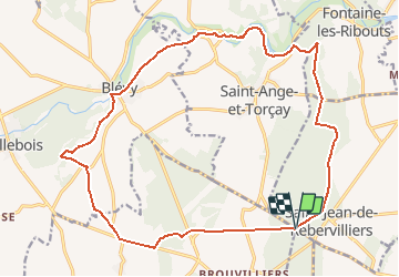
17.5 km | 19.7 km-effort
1h 30min
![](https://static1.geolcdn.com/siteimages/upload/files/16400158638029165_repeat_loop_refresh_sync_direction_icon.png)
Yes
![Trail Other activity Saint-Maixme-Hauterive - Châteauneuf - Photo](https://media.geolcdn.com/t/375/260/ext.jpg?maxdim=2&url=https%3A%2F%2Fstatic1.geolcdn.com%2Fsiteimages%2Fupload%2Ffiles%2F1545311037marcheuse_200dpi.jpg)
![Other activity Other activity](https://static1.geolcdn.com/sitytour/trail-icons/900.png)
Châteauneuf
Other activity
Very easy
Saint-Maixme-Hauterive,
Centre-Loire Valley,
Eure-et-Loir,
France
![](/images/other/stat-length.png)
3.3 km | 3.5 km-effort
1h 46min
![](https://static1.geolcdn.com/siteimages/upload/files/16400158638029165_repeat_loop_refresh_sync_direction_icon.png)
Yes
![Trail Nordic walking Châteauneuf-en-Thymerais - Château Neuf enThymeraie - Photo](https://media.geolcdn.com/t/375/260/ext.jpg?maxdim=2&url=https%3A%2F%2Fstatic1.geolcdn.com%2Fsiteimages%2Fupload%2Ffiles%2F1545311037marcheuse_200dpi.jpg)
![Nordic walking Nordic walking](https://static1.geolcdn.com/sitytour/trail-icons/102.png)
Château Neuf enThymeraie
Nordic walking
Medium
Châteauneuf-en-Thymerais,
Centre-Loire Valley,
Eure-et-Loir,
France
![](/images/other/stat-length.png)
10.2 km | 11.7 km-effort
2h 5min
![](https://static1.geolcdn.com/siteimages/upload/files/16400158638029165_repeat_loop_refresh_sync_direction_icon.png)
Yes
![Trail Walking Saint-Ange-et-Torçay - 11551150-St Ange 17.07 - Photo](https://media.geolcdn.com/t/375/260/ext.jpg?maxdim=2&url=https%3A%2F%2Fstatic1.geolcdn.com%2Fsiteimages%2Fupload%2Ffiles%2F1553511878bg_sport_marche.png)
![Walking Walking](https://static1.geolcdn.com/sitytour/trail-icons/101.png)
11551150-St Ange 17.07
Walking
Medium
Saint-Ange-et-Torçay,
Centre-Loire Valley,
Eure-et-Loir,
France
![](/images/other/stat-length.png)
17.6 km | 20 km-effort
Unknown
![](https://static1.geolcdn.com/siteimages/upload/files/16400158638029165_repeat_loop_refresh_sync_direction_icon.png)
Yes
![Trail Walking Saint-Maixme-Hauterive - saint m'aime Hauterive - Photo](https://media.geolcdn.com/t/375/260/ext.jpg?maxdim=2&url=https%3A%2F%2Fstatic1.geolcdn.com%2Fsiteimages%2Fupload%2Ffiles%2F1553511878bg_sport_marche.png)
![Walking Walking](https://static1.geolcdn.com/sitytour/trail-icons/101.png)
saint m'aime Hauterive
Walking
Medium
Saint-Maixme-Hauterive,
Centre-Loire Valley,
Eure-et-Loir,
France
![](/images/other/stat-length.png)
14.5 km | 16.3 km-effort
3h 32min
![](https://static1.geolcdn.com/siteimages/upload/files/16400158638029165_repeat_loop_refresh_sync_direction_icon.png)
No
![Trail Walking Maillebois - Maillebois Blevy - Photo](https://media.geolcdn.com/t/375/260/ext.jpg?maxdim=2&url=https%3A%2F%2Fstatic1.geolcdn.com%2Fsiteimages%2Fupload%2Ffiles%2F1553511878bg_sport_marche.png)
![Walking Walking](https://static1.geolcdn.com/sitytour/trail-icons/101.png)
Maillebois Blevy
Walking
Medium
Maillebois,
Centre-Loire Valley,
Eure-et-Loir,
France
![](/images/other/stat-length.png)
10.6 km | 11.9 km-effort
2h 47min
![](https://static1.geolcdn.com/siteimages/upload/files/16400158638029165_repeat_loop_refresh_sync_direction_icon.png)
Yes
![Trail Walking Châteauneuf-en-Thymerais - ALBG RANDO HOMMAGE JACQUES 2024 - Photo](https://media.geolcdn.com/t/375/260/ext.jpg?maxdim=2&url=https%3A%2F%2Fstatic1.geolcdn.com%2Fsiteimages%2Fupload%2Ffiles%2F1553511878bg_sport_marche.png)
![Walking Walking](https://static1.geolcdn.com/sitytour/trail-icons/101.png)
ALBG RANDO HOMMAGE JACQUES 2024
Walking
Medium
Châteauneuf-en-Thymerais,
Centre-Loire Valley,
Eure-et-Loir,
France
![](/images/other/stat-length.png)
9.9 km | 11.3 km-effort
2h 33min
![](https://static1.geolcdn.com/siteimages/upload/files/16400158638029165_repeat_loop_refresh_sync_direction_icon.png)
Yes
![Trail Walking Châteauneuf-en-Thymerais - 15707762-Châteauneuf en Thymerais 19.84 - Photo](https://media.geolcdn.com/t/375/260/ext.jpg?maxdim=2&url=https%3A%2F%2Fstatic1.geolcdn.com%2Fsiteimages%2Fupload%2Ffiles%2F1553511878bg_sport_marche.png)
![Walking Walking](https://static1.geolcdn.com/sitytour/trail-icons/101.png)
15707762-Châteauneuf en Thymerais 19.84
Walking
Medium
Châteauneuf-en-Thymerais,
Centre-Loire Valley,
Eure-et-Loir,
France
![](/images/other/stat-length.png)
19.8 km | 22 km-effort
Unknown
![](https://static1.geolcdn.com/siteimages/upload/files/16400158638029165_repeat_loop_refresh_sync_direction_icon.png)
Yes
![Trail Walking Saint-Ange-et-Torçay - 14558309-St Ange 17.00 - Photo](https://media.geolcdn.com/t/375/260/ext.jpg?maxdim=2&url=https%3A%2F%2Fstatic1.geolcdn.com%2Fsiteimages%2Fupload%2Ffiles%2F1553511878bg_sport_marche.png)
![Walking Walking](https://static1.geolcdn.com/sitytour/trail-icons/101.png)
14558309-St Ange 17.00
Walking
Medium
Saint-Ange-et-Torçay,
Centre-Loire Valley,
Eure-et-Loir,
France
![](/images/other/stat-length.png)
17 km | 19.8 km-effort
Unknown
![](https://static1.geolcdn.com/siteimages/upload/files/16400158638029165_repeat_loop_refresh_sync_direction_icon.png)
Yes