![](/images/other/stat-length.png)
![Trail Walking Gouzon - l'étang des grands champs - Photo](https://media.geolcdn.com/t/1900/400/ext.pjpeg?maxdim=2&url=https%3A%2F%2Fservices.sitytrail.com%2FGeolivesWS%2FDownloadMedia.ashx%3FTrailID%3D137702%26Media%3D8e224ab9-ff87-487a-b89f-7b880b24518b.jpg)
l'étang des grands champs
JeanLucA4
User
![Length](/images/other/stat-length.png)
Length
11.3 km
![Max alt](https://static1.geolcdn.com/siteimages/upload/files/1508320355ic_sort_altitude_max_24dp.png)
Max alt
398 m
![Uphill gradient](https://static1.geolcdn.com/siteimages/upload/files/1508320355ic_sort_den_pos_24dp.png)
Uphill gradient
68 m
![Km-Effort](/images/other/stat-length.png)
Km-Effort
12.2 km
![Min alt](https://static1.geolcdn.com/siteimages/upload/files/1508320355ic_sort_altitude_min_24dp.png)
Min alt
374 m
![Downhill gradient](https://static1.geolcdn.com/siteimages/upload/files/1508320355ic_sort_den_neg_24dp.png)
Downhill gradient
69 m
![Boucle](https://static1.geolcdn.com/siteimages/upload/files/16400158638029165_repeat_loop_refresh_sync_direction_icon.png)
Boucle
Yes
Creation date :
2014-12-10 00:00:00.0
Updated on :
2014-12-10 00:00:00.0
![Walking](https://static1.geolcdn.com/sitytour/trail-icons/101.png)
2h43
Difficulty : Easy
![Scan this QR Code to open this trail in the SityTrail application](https://capi.geolives.com/qq0zvz2zws4bq2lad0pu/sitytour/trails/137702/qr.png?size=200)
FREE GPS app for hiking
About
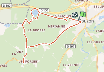
Trail Walking of 11.3 km to be discovered at New Aquitaine, Creuse, Gouzon. This trail is proposed by JeanLucA4.
Description
07/2012
Dans la Creuse, à partir de Gouzon,direction Lauradoueix, le Deignon, les Forges. Revenir vers l'étang des grands champs à partir du Deignon. Puis retour par l'ancienne N145.
Positioning
Country:
France
Region :
New Aquitaine
Department/Province :
Creuse
Municipality :
Gouzon
Location:
Unknown
Start:(Dec)
Start:(UTM)
440937 ; 5115671 (31T) N.
Comments
Trails nearby
![Trail Walking Gouzon - vers les étangs de thiolet - Photo](https://media.geolcdn.com/t/375/260/ext.jpg?maxdim=2&url=https%3A%2F%2Fservices.sitytrail.com%2FGeolivesWS%2FDownloadMedia.ashx%3FTrailID%3D319063%26Media%3D86abc16b-adda-4050-8034-5d139a773eeb.JPG)
![Walking Walking](https://static1.geolcdn.com/sitytour/trail-icons/101.png)
vers les étangs de thiolet
Walking
Easy
Gouzon,
New Aquitaine,
Creuse,
France
![](/images/other/stat-length.png)
8.6 km | 9.4 km-effort
2h 6min
![](https://static1.geolcdn.com/siteimages/upload/files/16400158638029165_repeat_loop_refresh_sync_direction_icon.png)
Yes