Trail Walking Formiguères - les camporeills - Photo
 xav34830
xav34830

User

© OpenStreetMap contributors
Length
Length
17.5 km
Max alt
Max alt
2416 m
Uphill gradient
Uphill gradient
763 m
Km-Effort
Km-Effort  
28 km
Min alt
Min alt
1779 m
Downhill gradient
Downhill gradient
769 m
Boucle
Boucle
Yes
Creation date :
2014-12-10 00:00:00.0
Updated on :
2014-12-10 00:00:00.0

(1 Reviews)

Walking
Walking
5h54
Difficulty : Easy

Scan this QR Code to open this trail in the SityTrail application

FREE GPS app for hiking

Logo SityTrail SityTrail

IGN / Geographical institutes

Download SityTrail from the App Store Download SityTrail from Google Play

Logo SityTrail SityTrail World

The world is yours!

Download SityTrail from the App Store Download SityTrail from Google Play Download SityTrail on Huawei AppGallery

About

Trail Walking of 17.5 km to be discovered at Occitania, Pyrénées-Orientales, Formiguères. This trail is proposed by xav34830.

Elevation profile

Photos

Positioning

Country:
France
Region :
Occitania
Department/Province :
Pyrénées-Orientales
Municipality :
Formiguères
Location:
Unknown
Start:(UTM)
422134 ; 4719627 (31T) N.

Comments

Please log in to post a review or rate the element


Toujours gros problème de dénivelle avec iPhone.ravi d'avoir les cartes espagnoles


Trails nearby

Trail Walking Formiguères - Les Camporells par la Lladure  - Photo
Walking
jcmartin

Walking

Medium
(1)
Formiguères, Occitania, Pyrénées-Orientales, France
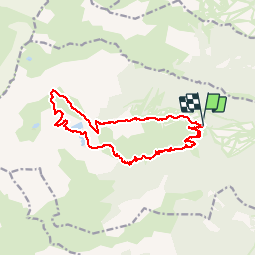
15.1 km | 24 km-effort
5h 7min
Yes
Trail sport Formiguères - 20240728 Station Formiguères - Camporeils - Photo
sport
ThonyM

sport

Very easy
Formiguères, Occitania, Pyrénées-Orientales, France
16 km | 27 km-effort
Unknown
Yes
Trail Walking Formiguères - 20210819 Porteille d’Orlu, étang du diable - Photo
Walking
ThonyM

Walking

Difficult
Formiguères, Occitania, Pyrénées-Orientales, France
16.4 km | 29 km-effort
5h 3min
Yes
Trail Walking Formiguères - 20210710 pla del bosc - Foumigueres - Photo
Walking
ThonyM

Walking

Easy
Formiguères, Occitania, Pyrénées-Orientales, France
12.5 km | 18.3 km-effort
2h 47min
Yes
Trail Snowshoes Les Angles - 2021-02-11 Sortie CAF - Les Angles - vers les Camporells - Photo
Snowshoes
eric.mignot

Snowshoes

Medium
Les Angles, Occitania, Pyrénées-Orientales, France
16.8 km | 24 km-effort
7h 0min
Yes
Trail Snowshoes Formiguères - Formigueres el collet  - Photo
Snowshoes
GUIDE
antignacs

Snowshoes

Very easy
Formiguères, Occitania, Pyrénées-Orientales, France
6.4 km | 8.7 km-effort
2h 47min
Yes
Trail Snowshoes Matemale - Tour lac mattemale neige  - Photo
Snowshoes
GUIDE
antignacs

Snowshoes

Very easy
Matemale, Occitania, Pyrénées-Orientales, France
9.1 km | 10.4 km-effort
3h 5min
Yes
Trail Walking Les Angles - Boucle depuis lac de Balcere vers Estany de l'Esparver - Photo
Walking
prous31

Walking

Medium
Les Angles, Occitania, Pyrénées-Orientales, France
13.4 km | 21 km-effort
4h 22min
Yes
Trail Walking Puyvalador - Rieutort  - Photo
Walking
merencianoep

Walking

Puyvalador, Occitania, Pyrénées-Orientales, France
7.8 km | 12.9 km-effort
2h 26min
Yes


Close
My subscriptions