![](/images/other/stat-length.png)
![Trail Mountain bike Poncin - 2 h de singles et de vignes - Poncin - Photo](https://media.geolcdn.com/t/1900/400/ext.pjpeg?maxdim=2&url=https%3A%2F%2Fstatic1.geolcdn.com%2Fsiteimages%2Fupload%2Ffiles%2F1524743154velo.jpg)
2 h de singles et de vignes - Poncin
tracegps
User
![Length](/images/other/stat-length.png)
![Max alt](https://static1.geolcdn.com/siteimages/upload/files/1508320355ic_sort_altitude_max_24dp.png)
![Uphill gradient](https://static1.geolcdn.com/siteimages/upload/files/1508320355ic_sort_den_pos_24dp.png)
![Km-Effort](/images/other/stat-length.png)
![Min alt](https://static1.geolcdn.com/siteimages/upload/files/1508320355ic_sort_altitude_min_24dp.png)
![Downhill gradient](https://static1.geolcdn.com/siteimages/upload/files/1508320355ic_sort_den_neg_24dp.png)
![Boucle](https://static1.geolcdn.com/siteimages/upload/files/16400158638029165_repeat_loop_refresh_sync_direction_icon.png)
![Mountain bike](https://static1.geolcdn.com/sitytour/trail-icons/202.png)
2h00
Difficulty : Difficult
![Scan this QR Code to open this trail in the SityTrail application](https://capi.geolives.com/qq0zvz2zws4bq2lad0pu/sitytour/trails/136870/qr.png?size=200)
FREE GPS app for hiking
About
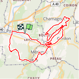
Trail Mountain bike of 25 km to be discovered at Auvergne-Rhône-Alpes, Ain, Poncin. This trail is proposed by tracegps.
Description
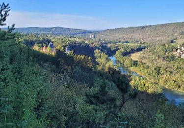
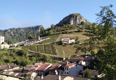
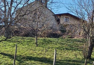
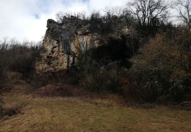
Après un départ de Poncin, un petit échauffement sur le plat. Puis à la sortie du 1er single, ça monte !!! On traverse les vignes de Cerdon, pour rejoindre le site d'escalade, que l'on va surplomber par un single technique. La proximité du vide imposera aux moins techniques (ou aux plus prudents) de mettre pied à terre sur de courtes portions Ce sera l'occasion d'une belle vue sur le village de Cerdon et ses alentours. A la sortie de ce passage, on rejoint par un chemin le village de Bôches, puis on revient à proximité du site d'escalade pour rejoindre, après un passage en sous-bois rafraîchissant, une autre portion de single technique. Une pause à l'église St Alban (en ruine) permet de contempler encore le paysage. Puis descente sur Cerdon, par un single technique et pentu, qui va faire chauffer les freins. Après avoir traversé le village, on longe le cours d'eau du Veyron. Au bout, 2 solutions : soit on rejoint la trace aller (juste en face), soit on a encore un peu de jus et on opte pour le reste du parcours qui ajoute un peu de dénivelé au compteur. On rejoint le village de Mérignat par un chemin pentu, puis on en sort par un autre sentier pentu (c'est la mode là-bas). Enfin descente sur le village de Breignes, qu'on traverse pour rejoindre les vignes et redescendre tranquillement sur Poncin par un chemin en légère descente qui reposera.
Positioning
Comments
Trails nearby
![Trail Walking Poncin - leymiat merignai breigne - Photo](https://media.geolcdn.com/t/375/260/ext.jpg?maxdim=2&url=https%3A%2F%2Fstatic1.geolcdn.com%2Fsiteimages%2Fupload%2Ffiles%2F1553511878bg_sport_marche.png)
![Walking Walking](https://static1.geolcdn.com/sitytour/trail-icons/101.png)
Walking
![](/images/other/stat-length.png)
![](https://static1.geolcdn.com/siteimages/upload/files/16400158638029165_repeat_loop_refresh_sync_direction_icon.png)
![Trail Walking Challes-la-Montagne - challes la montagne barrage lallement la cueille sameriat - Photo](https://media.geolcdn.com/t/375/260/3cb2918d-30ca-499e-bf94-e7bdff3fa3f8.jpg&format=jpg&maxdim=2)
![Walking Walking](https://static1.geolcdn.com/sitytour/trail-icons/101.png)
Walking
![](/images/other/stat-length.png)
![](https://static1.geolcdn.com/siteimages/upload/files/16400158638029165_repeat_loop_refresh_sync_direction_icon.png)
![Trail Walking Cerdon - 01_CERDON_CASCADE_FOUGE_18 km_780m - Photo](https://media.geolcdn.com/t/375/260/026a26c5-b2f7-4ada-8315-1f30b324ac8e.jpg&format=jpg&maxdim=2)
![Walking Walking](https://static1.geolcdn.com/sitytour/trail-icons/101.png)
Walking
![](/images/other/stat-length.png)
![](https://static1.geolcdn.com/siteimages/upload/files/16400158638029165_repeat_loop_refresh_sync_direction_icon.png)
![Trail Walking Poncin - les bords de l ain depart povin - Photo](https://media.geolcdn.com/t/375/260/1cf13da9-1f19-47d9-8ce3-5d16a77dd449.jpg&format=jpg&maxdim=2)
![Walking Walking](https://static1.geolcdn.com/sitytour/trail-icons/101.png)
Walking
![](/images/other/stat-length.png)
![](https://static1.geolcdn.com/siteimages/upload/files/16400158638029165_repeat_loop_refresh_sync_direction_icon.png)
![Trail Walking Jujurieux - 01-Jujurieux-Neuville-restau-18-7km-440m-fev22 - Photo](https://media.geolcdn.com/t/375/260/51235138-d6dc-494f-9a52-96125c4e0560.jpg&format=jpg&maxdim=2)
![Walking Walking](https://static1.geolcdn.com/sitytour/trail-icons/101.png)
Walking
![](/images/other/stat-length.png)
![](https://static1.geolcdn.com/siteimages/upload/files/16400158638029165_repeat_loop_refresh_sync_direction_icon.png)
![Trail Walking Cerdon - Le cerdon parr le drapeau - Photo](https://media.geolcdn.com/t/375/260/36e91cd3-f8b8-4408-8ac1-7b7204422aa9.jpg&format=jpg&maxdim=2)
![Walking Walking](https://static1.geolcdn.com/sitytour/trail-icons/101.png)
Walking
![](/images/other/stat-length.png)
![](https://static1.geolcdn.com/siteimages/upload/files/16400158638029165_repeat_loop_refresh_sync_direction_icon.png)
![Trail Road bike Poncin - Circuit l'Ain à vélo n° 22 - Et au milieu coule une rivière... - Photo](https://media.geolcdn.com/t/375/260/ext.jpg?maxdim=2&url=http%3A%2F%2Fwww.circuits-de-france.com%2Fimage%2Fphoto%2F7774_33600_0_fr.jpg)
![Road bike Road bike](https://static1.geolcdn.com/sitytour/trail-icons/201.png)
Road bike
![](/images/other/stat-length.png)
![](https://static1.geolcdn.com/siteimages/upload/files/16400158638029165_repeat_loop_refresh_sync_direction_icon.png)
![Trail Walking Cerdon - Cerdon : La cascade de Fouges (18 km - D. 823 m) - Photo](https://media.geolcdn.com/t/375/260/be00382b-1477-4d53-bf4f-55ec6d8fd5ca.jpg&format=jpg&maxdim=2)
![Walking Walking](https://static1.geolcdn.com/sitytour/trail-icons/101.png)
Walking
![](/images/other/stat-length.png)
![](https://static1.geolcdn.com/siteimages/upload/files/16400158638029165_repeat_loop_refresh_sync_direction_icon.png)
![Trail Walking Jujurieux - les châteaux de jujurieux - Photo](https://media.geolcdn.com/t/375/260/9583454c-9322-4e50-aa44-6fe2cafeea4d.jpg&format=jpg&maxdim=2)
![Walking Walking](https://static1.geolcdn.com/sitytour/trail-icons/101.png)
Walking
![](/images/other/stat-length.png)
![](https://static1.geolcdn.com/siteimages/upload/files/16400158638029165_repeat_loop_refresh_sync_direction_icon.png)