![](/images/other/stat-length.png)
![Trail Cycle Hoeilaart - Hoeilaart-La Hulpe-Foret de Soignes - Photo](https://media.geolcdn.com/t/1900/400/ext.pjpeg?maxdim=2&url=https%3A%2F%2Fstatic1.geolcdn.com%2Fsiteimages%2Fupload%2Ffiles%2F1524743154velo.jpg)
Hoeilaart-La Hulpe-Foret de Soignes
jcvroye
User
![Length](/images/other/stat-length.png)
Length
21 km
![Max alt](https://static1.geolcdn.com/siteimages/upload/files/1508320355ic_sort_altitude_max_24dp.png)
Max alt
152 m
![Uphill gradient](https://static1.geolcdn.com/siteimages/upload/files/1508320355ic_sort_den_pos_24dp.png)
Uphill gradient
304 m
![Km-Effort](/images/other/stat-length.png)
Km-Effort
25 km
![Min alt](https://static1.geolcdn.com/siteimages/upload/files/1508320355ic_sort_altitude_min_24dp.png)
Min alt
63 m
![Downhill gradient](https://static1.geolcdn.com/siteimages/upload/files/1508320355ic_sort_den_neg_24dp.png)
Downhill gradient
304 m
![Boucle](https://static1.geolcdn.com/siteimages/upload/files/16400158638029165_repeat_loop_refresh_sync_direction_icon.png)
Boucle
Yes
Creation date :
2014-12-10 00:00:00.0
Updated on :
2014-12-10 00:00:00.0
![Cycle](https://static1.geolcdn.com/sitytour/trail-icons/200.png)
1h23
Difficulty : Easy
![Scan this QR Code to open this trail in the SityTrail application](https://capi.geolives.com/qq0zvz2zws4bq2lad0pu/sitytour/trails/136789/qr.png?size=200)
FREE GPS app for hiking
About
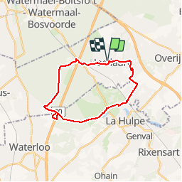
Trail Cycle of 21 km to be discovered at Flanders, Flemish Brabant, Hoeilaart. This trail is proposed by jcvroye.
Description
Balade au départ de la place de Hoeilaart ( Parking aisé ) et passage par le château de La Hulpe, Forêt de Soignes, Groenendael ( Passerelle du chemin de fer ) et retour
Positioning
Country:
Belgium
Region :
Flanders
Department/Province :
Flemish Brabant
Municipality :
Hoeilaart
Location:
Hoeilaart
Start:(Dec)
Start:(UTM)
603844 ; 5625080 (31U) N.
Comments
Trails nearby
![Trail Walking Hoeilaart - GG-Bw-04_Hoeilaart - Genval - Photo](https://media.geolcdn.com/t/375/260/364592d0-bbf8-45ce-9ea9-708b8ca7581f.jpg&format=jpg&maxdim=2)
![Walking Walking](https://static1.geolcdn.com/sitytour/trail-icons/101.png)
GG-Bw-04_Hoeilaart - Genval
Walking
Very difficult
(6)
Hoeilaart,
Flanders,
Flemish Brabant,
Belgium
![](/images/other/stat-length.png)
23 km | 28 km-effort
5h 54min
![](https://static1.geolcdn.com/siteimages/upload/files/16400158638029165_repeat_loop_refresh_sync_direction_icon.png)
No
![Trail Walking Auderghem - Oudergem - RB-Br-09 Raccourci 2 - Photo](https://media.geolcdn.com/t/375/260/ext.jpg?maxdim=2&url=https%3A%2F%2Fservices.sitytrail.com%2FGeolivesWS%2FDownloadMedia.ashx%3FTrailID%3D247903%26Media%3D4f2f6ef8-5647-4df5-b72e-d8a55c5e5b6f.jpg)
![Walking Walking](https://static1.geolcdn.com/sitytour/trail-icons/101.png)
RB-Br-09 Raccourci 2
Walking
Easy
(9)
Auderghem - Oudergem,
Brussels-Capital,
Unknown,
Belgium
![](/images/other/stat-length.png)
15.3 km | 18 km-effort
4h 5min
![](https://static1.geolcdn.com/siteimages/upload/files/16400158638029165_repeat_loop_refresh_sync_direction_icon.png)
Yes
![Trail Walking Auderghem - Oudergem - RB-Br-09 - Photo](https://media.geolcdn.com/t/375/260/ext.jpg?maxdim=2&url=https%3A%2F%2Fservices.sitytrail.com%2FGeolivesWS%2FDownloadMedia.ashx%3FTrailID%3D247899%26Media%3D7b6d3a4f-3999-4d35-8f7d-f23163489b77.jpg)
![Walking Walking](https://static1.geolcdn.com/sitytour/trail-icons/101.png)
RB-Br-09
Walking
Medium
(8)
Auderghem - Oudergem,
Brussels-Capital,
Unknown,
Belgium
![](/images/other/stat-length.png)
20 km | 25 km-effort
5h 34min
![](https://static1.geolcdn.com/siteimages/upload/files/16400158638029165_repeat_loop_refresh_sync_direction_icon.png)
Yes
![Trail Walking La Hulpe - RB-Bw-12 - Raccourci - Forêt et campagnes au sud de Bruxelles - Photo](https://media.geolcdn.com/t/375/260/ext.jpg?maxdim=2&url=https%3A%2F%2Fservices.sitytrail.com%2FGeolivesWS%2FDownloadMedia.ashx%3FTrailID%3D220408%26Media%3D24b0bc9e-ebac-4d93-8d00-eff7571ad0a0.jpg)
![Walking Walking](https://static1.geolcdn.com/sitytour/trail-icons/101.png)
RB-Bw-12 - Raccourci - Forêt et campagnes au sud de Bruxelles
Walking
Difficult
(15)
La Hulpe,
Wallonia,
Walloon Brabant,
Belgium
![](/images/other/stat-length.png)
14.3 km | 17.7 km-effort
4h 1min
![](https://static1.geolcdn.com/siteimages/upload/files/16400158638029165_repeat_loop_refresh_sync_direction_icon.png)
Yes
![Trail Mountain bike Sint-Genesius-Rode - VTT des etangs - Photo](https://media.geolcdn.com/t/375/260/ext.jpg?maxdim=2&url=https%3A%2F%2Fservices.sitytrail.com%2FGeolivesWS%2FDownloadMedia.ashx%3FTrailID%3D672124%26Media%3Df9c91142-2f99-4e68-a9bd-48ecc49645c7.JPG)
![Mountain bike Mountain bike](https://static1.geolcdn.com/sitytour/trail-icons/202.png)
VTT des etangs
Mountain bike
Medium
(1)
Sint-Genesius-Rode,
Flanders,
Flemish Brabant,
Belgium
![](/images/other/stat-length.png)
31 km | 37 km-effort
2h 24min
![](https://static1.geolcdn.com/siteimages/upload/files/16400158638029165_repeat_loop_refresh_sync_direction_icon.png)
No
![Trail Walking La Hulpe - La Hulpe - Circuit Natura 2000, des sites qui valent le détour - Bw02 - Photo](https://media.geolcdn.com/t/375/260/7fa79586-43de-4fc0-89c7-4bc45138438a.jpg&format=jpg&maxdim=2)
![Walking Walking](https://static1.geolcdn.com/sitytour/trail-icons/101.png)
La Hulpe - Circuit Natura 2000, des sites qui valent le détour - Bw02
Walking
Medium
(5)
La Hulpe,
Wallonia,
Walloon Brabant,
Belgium
![](/images/other/stat-length.png)
4.7 km | 5.9 km-effort
1h 16min
![](https://static1.geolcdn.com/siteimages/upload/files/16400158638029165_repeat_loop_refresh_sync_direction_icon.png)
No
![Trail Mountain bike Sint-Genesius-Rode - vtt de la forêt de Soigne - Photo](https://media.geolcdn.com/t/375/260/ext.jpg?maxdim=2&url=https%3A%2F%2Fservices.sitytrail.com%2FGeolivesWS%2FDownloadMedia.ashx%3FTrailID%3D394333%26Media%3Daba8d68d-2f84-442f-b081-8683a39ccf4b.JPG)
![Mountain bike Mountain bike](https://static1.geolcdn.com/sitytour/trail-icons/202.png)
vtt de la forêt de Soigne
Mountain bike
Easy
(1)
Sint-Genesius-Rode,
Flanders,
Flemish Brabant,
Belgium
![](/images/other/stat-length.png)
31 km | 38 km-effort
2h 27min
![](https://static1.geolcdn.com/siteimages/upload/files/16400158638029165_repeat_loop_refresh_sync_direction_icon.png)
Yes
![Trail Walking Sint-Genesius-Rode - De Rhode Saint-Genèse à Groenendaal parl la forêt de Soignes - Photo](https://media.geolcdn.com/t/375/260/ext.jpg?maxdim=2&url=https%3A%2F%2Fservices.sitytrail.com%2FGeolivesWS%2FDownloadMedia.ashx%3FTrailID%3D361516%26Media%3Dafc15552-96c3-47a7-a25a-a7fd8498bfed.JPG)
![Walking Walking](https://static1.geolcdn.com/sitytour/trail-icons/101.png)
De Rhode Saint-Genèse à Groenendaal parl la forêt de Soignes
Walking
Easy
(4)
Sint-Genesius-Rode,
Flanders,
Flemish Brabant,
Belgium
![](/images/other/stat-length.png)
10.3 km | 11.9 km-effort
2h 36min
![](https://static1.geolcdn.com/siteimages/upload/files/16400158638029165_repeat_loop_refresh_sync_direction_icon.png)
Yes
![Trail Walking Auderghem - Oudergem - RB-Br-09 Raccourci 1 - Photo](https://media.geolcdn.com/t/375/260/ext.jpg?maxdim=2&url=https%3A%2F%2Fservices.sitytrail.com%2FGeolivesWS%2FDownloadMedia.ashx%3FTrailID%3D247901%26Media%3D4f2f6ef8-5647-4df5-b72e-d8a55c5e5b6f.jpg)
![Walking Walking](https://static1.geolcdn.com/sitytour/trail-icons/101.png)
RB-Br-09 Raccourci 1
Walking
Easy
(4)
Auderghem - Oudergem,
Brussels-Capital,
Unknown,
Belgium
![](/images/other/stat-length.png)
16 km | 19.1 km-effort
4h 20min
![](https://static1.geolcdn.com/siteimages/upload/files/16400158638029165_repeat_loop_refresh_sync_direction_icon.png)
Yes
belle variété entre village château et foret
assenois