Trail Snowshoes Crest-Voland - Crest- Voland - Photo
© OpenStreetMap contributors
Length
Length
4.7 km
Max alt
Max alt
1596 m
Uphill gradient
Uphill gradient
395 m
Km-Effort
Km-Effort  
8.7 km
Min alt
Min alt
1210 m
Downhill gradient
Downhill gradient
26 m
Boucle
Boucle
No
Creation date :
2014-12-10 00:00:00.0
Updated on :
2014-12-10 00:00:00.0

(0 Reviews)

Snowshoes
Snowshoes
2h00
Difficulty : Unknown

Scan this QR Code to open this trail in the SityTrail application

FREE GPS app for hiking

Logo SityTrail SityTrail

IGN / Geographical institutes

Download SityTrail from the App Store Download SityTrail from Google Play

Logo SityTrail SityTrail World

The world is yours!

Download SityTrail from the App Store Download SityTrail from Google Play Download SityTrail on Huawei AppGallery

About

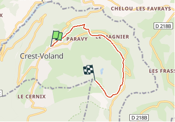
Trail Snowshoes of 4.7 km to be discovered at Auvergne-Rhône-Alpes, Savoy, Crest-Voland. This trail is proposed by albertville.

Description

Le Lachat par le Versant Est

Elevation profile

Points of interest

Point of interest Crest-Voland - Passage de route - Photo
albertville
CREST-VOLAND 

Positioning

Country:
France
Region :
Auvergne-Rhône-Alpes
Department/Province :
Savoy
Municipality :
Crest-Voland
Location:
Unknown
Start:(UTM)
306143 ; 5074338 (32T) N.

Trails nearby

Trail Walking Hauteluce - sous Bisanne au lac des Saisies - Photo
Walking
syl_34

Walking

Medium
(1)
Hauteluce, Auvergne-Rhône-Alpes, Savoy, France
18.1 km | 28 km-effort
5h 36min
Yes
Trail Walking Praz-sur-Arly - Balade dans le Val d'Arly - Le Crêt du Midi - Photo
Walking
tracegps

Walking

Difficult
(2)
Praz-sur-Arly, Auvergne-Rhône-Alpes, Upper Savoy, France
11.2 km | 21 km-effort
5h 0min
Yes
Trail Walking Cohennoz - suuntoapp-Hiking-2024-09-12T06-49-26Z - Photo
Walking
GUIDE
holtzv

Walking

Very difficult
Cohennoz, Auvergne-Rhône-Alpes, Savoy, France
22 km | 37 km-effort
8h 21min
No
Trail Walking Notre-Dame-de-Bellecombe - NOTRE DAME DE BELLECOMBE - Photo
Walking
albertville

Walking

Very easy
(3)
Notre-Dame-de-Bellecombe, Auvergne-Rhône-Alpes, Savoy, France
13.3 km | 23 km-effort
5h 15min
Yes
Trail Walking Saint-Nicolas-la-Chapelle - Saint Nicolas la Chapelle - Photo
Walking
albertville

Walking

Very easy
(1)
Saint-Nicolas-la-Chapelle, Auvergne-Rhône-Alpes, Savoy, France
9.3 km | 18.2 km-effort
4h 3min
Yes
Trail Walking Saint-Nicolas-la-Chapelle - SAINT NICOLAS LA CHAPELLE - Photo
Walking
albertville

Walking

Very easy
(1)
Saint-Nicolas-la-Chapelle, Auvergne-Rhône-Alpes, Savoy, France
9.5 km | 16.8 km-effort
3h 41min
No
Trail Walking Hauteluce - Mont Clocher - Photo
Walking
aglagla5

Walking

Very easy
(2)
Hauteluce, Auvergne-Rhône-Alpes, Savoy, France
7.3 km | 10.4 km-effort
1h 47min
Yes
Trail Walking Praz-sur-Arly - Torraz christomet 928m 18kms  - Photo
Walking
GUIDE
Danielba

Walking

Medium
Praz-sur-Arly, Auvergne-Rhône-Alpes, Upper Savoy, France
16.2 km | 29 km-effort
7h 13min
No
Trail Walking Praz-sur-Arly - Praz sur arly ban rouge  1050m 18.7kms  - Photo
Walking
GUIDE
Danielba

Walking

Medium
Praz-sur-Arly, Auvergne-Rhône-Alpes, Upper Savoy, France
17.4 km | 31 km-effort
8h 40min
Yes


Close
My subscriptions