Trail Walking La Chapelle-en-Valgaudémar - gioberney  - Photo
© OpenStreetMap contributors
Length
Length
24 km
Max alt
Max alt
2584 m
Uphill gradient
Uphill gradient
1138 m
Km-Effort
Km-Effort  
41 km
Min alt
Min alt
1091 m
Downhill gradient
Downhill gradient
1674 m
Boucle
Boucle
No
Creation date :
2014-12-10 00:00:00.0
Updated on :
2014-12-10 00:00:00.0

(0 Reviews)

Walking
Walking
7h38
Difficulty : Medium

Scan this QR Code to open this trail in the SityTrail application

FREE GPS app for hiking

Logo SityTrail SityTrail

IGN / Geographical institutes

Download SityTrail from the App Store Download SityTrail from Google Play

Logo SityTrail SityTrail World

The world is yours!

Download SityTrail from the App Store Download SityTrail from Google Play Download SityTrail on Huawei AppGallery

About

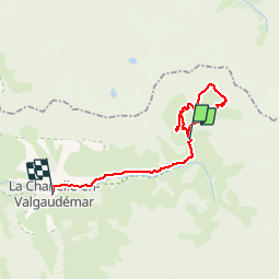
Trail Walking of 24 km to be discovered at Provence-Alpes-Côte d'Azur, Hautes-Alpes, La Chapelle-en-Valgaudémar. This trail is proposed by renaud.levant.

Description

Départ du chalet du Gioberney, à l'extrêmité nord-est du Valgaudemar; passage par le lac du Lauzon, puis montée au refuge du Pigeonnier et retour.

Elevation profile

Positioning

Country:
France
Region :
Provence-Alpes-Côte d'Azur
Department/Province :
Hautes-Alpes
Municipality :
La Chapelle-en-Valgaudémar
Location:
Unknown
Start:(UTM)
285123 ; 4968932 (32T) N.

Trails nearby

Trail Walking La Chapelle-en-Valgaudémar - Refuge de Chalance - Photo
Walking
GUIDE
Marco05

Walking

Difficult
(1)
La Chapelle-en-Valgaudémar, Provence-Alpes-Côte d'Azur, Hautes-Alpes, France
7.5 km | 22 km-effort
5h 1min
Yes
Trail Walking La Chapelle-en-Valgaudémar - Tour du Vieux Chaillol 2/5 - Du Gîte Le Casset au Refuge de Vallonpierre - Photo
Walking
tracegps

Walking

Medium
(1)
La Chapelle-en-Valgaudémar, Provence-Alpes-Côte d'Azur, Hautes-Alpes, France
11.8 km | 24 km-effort
4h 30min
No
Trail On foot La Chapelle-en-Valgaudémar - Refuge du Pigeonnier - Photo
On foot
GUIDE
Marco05

On foot

Difficult
La Chapelle-en-Valgaudémar, Provence-Alpes-Côte d'Azur, Hautes-Alpes, France
7.8 km | 18.6 km-effort
4h 13min
Yes
Trail On foot La Chapelle-en-Valgaudémar - Refuge de Vallonpierre - Photo
On foot
GUIDE
Marco05

On foot

Difficult
La Chapelle-en-Valgaudémar, Provence-Alpes-Côte d'Azur, Hautes-Alpes, France
13.8 km | 24 km-effort
5h 33min
Yes
Trail On foot La Chapelle-en-Valgaudémar - Refuge de Chabournéou - Photo
On foot
GUIDE
Marco05

On foot

Medium
La Chapelle-en-Valgaudémar, Provence-Alpes-Côte d'Azur, Hautes-Alpes, France
10.2 km | 17.1 km-effort
3h 53min
Yes
Trail Walking La Chapelle-en-Valgaudémar - Valgaudemar - Gioberney Lac du Lauzon  - 7.3km 490m 2h45 - 2018 06 27 - public - Photo
Walking
GUIDE
Orcal37

Walking

Difficult
La Chapelle-en-Valgaudémar, Provence-Alpes-Côte d'Azur, Hautes-Alpes, France
7.2 km | 13.6 km-effort
4h 30min
Yes
Trail Walking La Chapelle-en-Valgaudémar - Valgaudemar - Rif du Sap Le Clot - 6km 190m 1h45 - 2018 07 04 - public - Photo
Walking
GUIDE
Orcal37

Walking

Medium
La Chapelle-en-Valgaudémar, Provence-Alpes-Côte d'Azur, Hautes-Alpes, France
6 km | 8.5 km-effort
2h 20min
Yes
Trail Walking La Chapelle-en-Valgaudémar - Valgaudemar - Gioberney Refuge de Vallonpierre - 16km 850m 5h35 - 2018 07 03 - public - Photo
Walking
GUIDE
Orcal37

Walking

Difficult
La Chapelle-en-Valgaudémar, Provence-Alpes-Côte d'Azur, Hautes-Alpes, France
16 km | 27 km-effort
7h 35min
Yes
Trail Walking La Chapelle-en-Valgaudémar - PARC NATIONAL DES ECRINS: REFUGE DU PIGEONNIER - Photo
Walking
djeepee74

Walking

Medium
La Chapelle-en-Valgaudémar, Provence-Alpes-Côte d'Azur, Hautes-Alpes, France
9.4 km | 21 km-effort
3h 22min
Yes


Close
My subscriptions