Trail Walking Meuzac - le césar - Photo
© OpenStreetMap contributors
Length
Length
16.1 km
Max alt
Max alt
474 m
Uphill gradient
Uphill gradient
236 m
Km-Effort
Km-Effort  
19.3 km
Min alt
Min alt
385 m
Downhill gradient
Downhill gradient
240 m
Boucle
Boucle
Yes
Creation date :
2014-12-10 00:00:00.0
Updated on :
2014-12-10 00:00:00.0

(1 Reviews)

Walking
Walking
3h06
Difficulty : Easy

Scan this QR Code to open this trail in the SityTrail application

FREE GPS app for hiking

Logo SityTrail SityTrail

IGN / Geographical institutes

Download SityTrail from the App Store Download SityTrail from Google Play

Logo SityTrail SityTrail World

The world is yours!

Download SityTrail from the App Store Download SityTrail from Google Play Download SityTrail on Huawei AppGallery

About

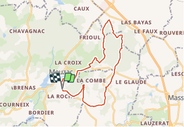
Trail Walking of 16.1 km to be discovered at New Aquitaine, Haute-Vienne, Meuzac. This trail is proposed by marcheur75.

Description

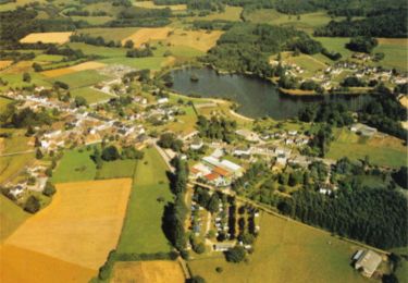
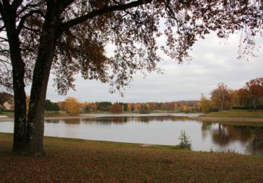
Ballade dans les bois et les étangs de Meuzac
Bonne ballade
         

Elevation profile

Photos

Points of interest

Point of interest Saint-Germain-les-Belles - Etang - Photo
marcheur75
SAINT-GERMAIN-LES-BELLES 

Positioning

Country:
France
Region :
New Aquitaine
Department/Province :
Haute-Vienne
Municipality :
Meuzac
Location:
Unknown
Start:(UTM)
378266 ; 5044651 (31T) N.

Comments

Please log in to post a review or rate the element
 

Trails nearby

Trail Walking Meuzac - Autour du Plan d'Eau de Forge Neuve - Meuzac - Photo
Walking
tracegps

Walking

Easy
Meuzac, New Aquitaine, Haute-Vienne, France
8.3 km | 10.1 km-effort
1h 30min
Yes
Trail Mountain bike Meuzac - De landes en forêts - Meuzac - Photo
Mountain bike
tracegps

Mountain bike

Difficult
Meuzac, New Aquitaine, Haute-Vienne, France
28 km | 36 km-effort
2h 30min
Yes
Trail Walking Meuzac - De landes en forêts - Meuzac - Photo
Walking
tracegps

Walking

Difficult
Meuzac, New Aquitaine, Haute-Vienne, France
28 km | 36 km-effort
6h 30min
Yes
Trail Walking Meuzac - Meuzac-en partie père castor.  - Photo
Walking
Georges 18

Walking

Medium
Meuzac, New Aquitaine, Haute-Vienne, France
6.3 km | 7.7 km-effort
1h 26min
No
Trail Walking Benayes - Benayes- Le Pont Faure - Photo
Walking
houbart

Walking

Very easy
Benayes, New Aquitaine, Corrèze, France
7.3 km | 9.3 km-effort
1h 59min
Yes
Trail Walking Montgibaud - Montgibaud- Le tilleul de Sully - Photo
Walking
houbart

Walking

Easy
Montgibaud, New Aquitaine, Corrèze, France
7.4 km | 9.6 km-effort
2h 0min
Yes
Trail Mountain bike Meuzac - et tu f - Photo
Mountain bike
pjoly

Mountain bike

Very difficult
Meuzac, New Aquitaine, Haute-Vienne, France
36 km | 49 km-effort
27min
No


Close
My subscriptions