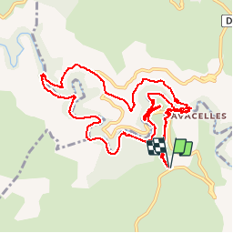
![](/images/other/stat-length.png)
![Trail Walking Saint-Maurice-Navacelles - Cirque de Navacelles par baume Auriol - Photo](https://media.geolcdn.com/t/1900/400/ext.pjpeg?maxdim=2&url=https%3A%2F%2Fstatic1.geolcdn.com%2Fsiteimages%2Fupload%2Ffiles%2F1553511878bg_sport_marche.png)
Cirque de Navacelles par baume Auriol
mitika
User
![Length](/images/other/stat-length.png)
![Max alt](https://static1.geolcdn.com/siteimages/upload/files/1508320355ic_sort_altitude_max_24dp.png)
![Uphill gradient](https://static1.geolcdn.com/siteimages/upload/files/1508320355ic_sort_den_pos_24dp.png)
![Km-Effort](/images/other/stat-length.png)
![Min alt](https://static1.geolcdn.com/siteimages/upload/files/1508320355ic_sort_altitude_min_24dp.png)
![Downhill gradient](https://static1.geolcdn.com/siteimages/upload/files/1508320355ic_sort_den_neg_24dp.png)
![Boucle](https://static1.geolcdn.com/siteimages/upload/files/16400158638029165_repeat_loop_refresh_sync_direction_icon.png)
![Walking](https://static1.geolcdn.com/sitytour/trail-icons/101.png)
--
Difficulty : Difficult
![Scan this QR Code to open this trail in the SityTrail application](https://capi.geolives.com/qq0zvz2zws4bq2lad0pu/sitytour/trails/132730/qr.png?size=200)
FREE GPS app for hiking
About
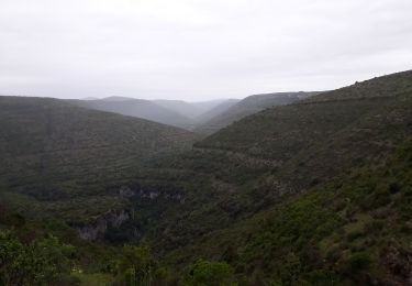
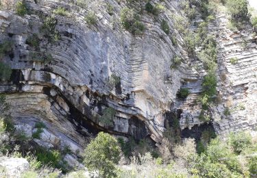
Trail Walking of 13.9 km to be discovered at Occitania, Hérault, Saint-Maurice-Navacelles. This trail is proposed by mitika.
Description
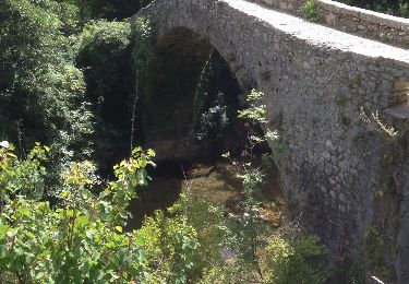
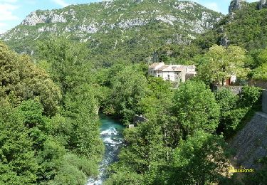
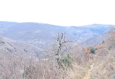
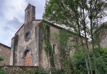
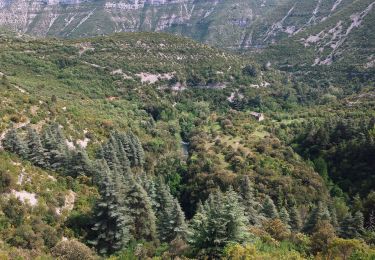
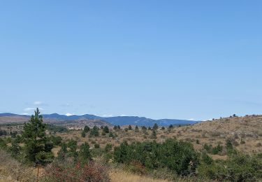
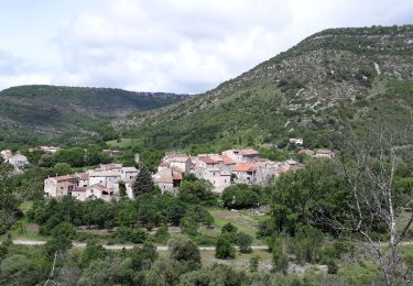
Départ randonnée : La Baume Auriol (Hérault 34) Cirque de Navacelles : Variante par la Baume Auriol (difficulté moyenne).La descente dans le cirque est pentue sur un chemin étroit et il faut garder des forces pour la remontée.Ce circuit peut aussi se faire depuis le village de Navacelles en faisant la descente dans le cirque en voiture.
Positioning
Comments
Trails nearby
![Trail Walking Saint-Maurice-Navacelles - cirque de Navacelles - Photo](https://media.geolcdn.com/t/375/260/ext.jpg?maxdim=2&url=https%3A%2F%2Fservices.sitytrail.com%2FGeolivesWS%2FDownloadMedia.ashx%3FTrailID%3D331316%26Media%3D20140805152414.jpg)
![Walking Walking](https://static1.geolcdn.com/sitytour/trail-icons/101.png)
Walking
![](/images/other/stat-length.png)
![](https://static1.geolcdn.com/siteimages/upload/files/16400158638029165_repeat_loop_refresh_sync_direction_icon.png)
![Trail Walking Rogues - Madières - La Sauvie - Photo](https://media.geolcdn.com/t/375/260/ext.jpg?maxdim=2&url=https%3A%2F%2Fservices.sitytrail.com%2FGeolivesWS%2FDownloadMedia.ashx%3FTrailID%3D214916%26Media%3D15483_6.jpg)
![Walking Walking](https://static1.geolcdn.com/sitytour/trail-icons/101.png)
Walking
![](/images/other/stat-length.png)
![](https://static1.geolcdn.com/siteimages/upload/files/16400158638029165_repeat_loop_refresh_sync_direction_icon.png)
![Trail Walking Vissec - sentier du Regagnas - Photo](https://media.geolcdn.com/t/375/260/da6617d7-2a0d-4d03-9eaa-131f37014f58.jpg&format=jpg&maxdim=2)
![Walking Walking](https://static1.geolcdn.com/sitytour/trail-icons/101.png)
Walking
![](/images/other/stat-length.png)
![](https://static1.geolcdn.com/siteimages/upload/files/16400158638029165_repeat_loop_refresh_sync_direction_icon.png)
![Trail On foot Saint-Maurice-Navacelles - Navacelles Vissec par le chemin du facteur - Photo](https://media.geolcdn.com/t/375/260/5eb51299-e303-4e2d-9d78-ac9fc254c62c.jpeg&format=jpg&maxdim=2)
![On foot On foot](https://static1.geolcdn.com/sitytour/trail-icons/100.png)
On foot
![](/images/other/stat-length.png)
![](https://static1.geolcdn.com/siteimages/upload/files/16400158638029165_repeat_loop_refresh_sync_direction_icon.png)
![Trail On foot Blandas - Randonnée Cirque de Navacelles - Causse de Blandas - Vissec - Moulin de la Foux - Photo](https://media.geolcdn.com/t/375/260/8ddb3d2c-f886-47a1-a994-79ae500f0ce8.jpeg&format=jpg&maxdim=2)
![On foot On foot](https://static1.geolcdn.com/sitytour/trail-icons/100.png)
On foot
![](/images/other/stat-length.png)
![](https://static1.geolcdn.com/siteimages/upload/files/16400158638029165_repeat_loop_refresh_sync_direction_icon.png)
![Trail Walking Blandas - Causse de Blandas et Vallée de la Vis - Photo](https://media.geolcdn.com/t/375/260/63d6e02c-c419-4b36-9d67-d9ec414c30bc.jpg&format=jpg&maxdim=2)
![Walking Walking](https://static1.geolcdn.com/sitytour/trail-icons/101.png)
Walking
![](/images/other/stat-length.png)
![](https://static1.geolcdn.com/siteimages/upload/files/16400158638029165_repeat_loop_refresh_sync_direction_icon.png)
![Trail Walking Blandas - Vissec / Moulin de la Foux - Photo](https://media.geolcdn.com/t/375/260/10a13c13-90e1-488e-8e53-bc3d65b1bc36.jpg&format=jpg&maxdim=2)
![Walking Walking](https://static1.geolcdn.com/sitytour/trail-icons/101.png)
Walking
![](/images/other/stat-length.png)
![](https://static1.geolcdn.com/siteimages/upload/files/16400158638029165_repeat_loop_refresh_sync_direction_icon.png)
![Trail Walking Blandas - Bois de calot rouge - Photo](https://media.geolcdn.com/t/375/260/a9a713a3-ac0f-45b3-9482-9c5a24bfa783.jpg&format=jpg&maxdim=2)
![Walking Walking](https://static1.geolcdn.com/sitytour/trail-icons/101.png)
Walking
![](/images/other/stat-length.png)
![](https://static1.geolcdn.com/siteimages/upload/files/16400158638029165_repeat_loop_refresh_sync_direction_icon.png)
![Trail Walking Saint-Maurice-Navacelles - Cirque de Navacelles Causses et Gorges de la Vis - Photo](https://media.geolcdn.com/t/375/260/dae2c70d-6c56-4f7c-a199-7ae450c239f7.jpg&format=jpg&maxdim=2)
![Walking Walking](https://static1.geolcdn.com/sitytour/trail-icons/101.png)
Walking
![](/images/other/stat-length.png)
![](https://static1.geolcdn.com/siteimages/upload/files/16400158638029165_repeat_loop_refresh_sync_direction_icon.png)