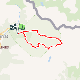
![](/images/other/stat-length.png)
![Trail Walking el Serrat - refugi-sorteny-pic-estanyo-pic-cabaneta - Photo](https://media.geolcdn.com/t/1900/400/ext.pjpeg?maxdim=2&url=https%3A%2F%2Fstatic1.geolcdn.com%2Fsiteimages%2Fupload%2Ffiles%2F1553511878bg_sport_marche.png)
refugi-sorteny-pic-estanyo-pic-cabaneta
phidge
User
![Length](/images/other/stat-length.png)
![Max alt](https://static1.geolcdn.com/siteimages/upload/files/1508320355ic_sort_altitude_max_24dp.png)
![Uphill gradient](https://static1.geolcdn.com/siteimages/upload/files/1508320355ic_sort_den_pos_24dp.png)
![Km-Effort](/images/other/stat-length.png)
![Min alt](https://static1.geolcdn.com/siteimages/upload/files/1508320355ic_sort_altitude_min_24dp.png)
![Downhill gradient](https://static1.geolcdn.com/siteimages/upload/files/1508320355ic_sort_den_neg_24dp.png)
![Boucle](https://static1.geolcdn.com/siteimages/upload/files/16400158638029165_repeat_loop_refresh_sync_direction_icon.png)
![Walking](https://static1.geolcdn.com/sitytour/trail-icons/101.png)
--
Difficulty : Unknown
![Scan this QR Code to open this trail in the SityTrail application](https://capi.geolives.com/qq0zvz2zws4bq2lad0pu/sitytour/trails/131509/qr.png?size=200)
FREE GPS app for hiking
About
Trail Walking of 11.8 km to be discovered at Andorra. This trail is proposed by phidge.
Description
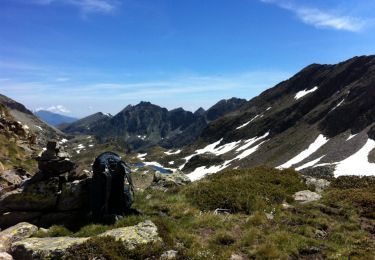
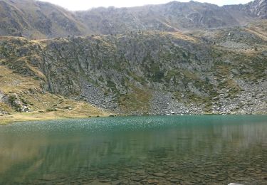
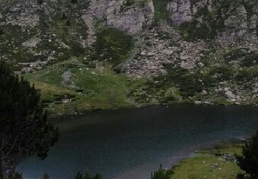
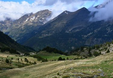
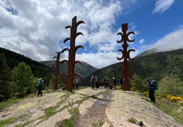
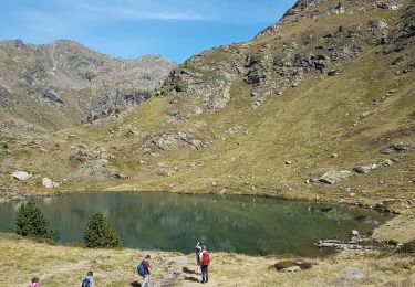
Excursió per terres Andorranes. Deixem el cotxe al Grau de la Llosa. En pocs minuts arribem fins al Refugi de Sorteny. Agafem el camí que ens porta fins el Pic de l'Estanyó, tot passant pel Roc del Rellotge, l'Estanyó. Una forta pujada per la Serra del Roc del Rellotge ens porta finalment fins el Pic de l'Estanyó, de 2915m. A partir d'aquí descendim una miqueta cap als colls de més a l'est, fins que una suau pendent en porta fins el Pic de la Cabaneta, de 2862m. Baixem inicialment pel camí marcat que porta fins a la Collada de Meners, però abans de començar a pujar ens desviem camp a través per tarteres i clapes de neu fins anar a buscar el GRP. Passant pel Pas de Serrera, i de nou, pel refugi de Sorteny, el GR ens porta fins al cotxe.
Positioning
Comments
Trails nearby
![Trail Walking - llorts_lac_angonella - Photo](https://media.geolcdn.com/t/375/260/ext.jpg?maxdim=2&url=https%3A%2F%2Fservices.sitytrail.com%2FGeolivesWS%2FDownloadMedia.ashx%3FTrailID%3D793517%26Media%3Dfix__20170721150953.jpg)
![Walking Walking](https://static1.geolcdn.com/sitytour/trail-icons/101.png)
![Trail Walking - Lac Estany de l'Estanyo - Photo](https://media.geolcdn.com/t/375/260/ext.jpg?maxdim=2&url=https%3A%2F%2Fmedia.geolcdn.com%2Ff%2Ff7c5075f-2281-4dcd-8411-36ac3bb86224.JPG)
![Walking Walking](https://static1.geolcdn.com/sitytour/trail-icons/101.png)
![Trail Walking - Andorre TSM groupe 2 vendredi 13 septembre - Photo](https://media.geolcdn.com/t/375/260/ext.jpg?maxdim=2&url=https%3A%2F%2Fmedia.geolcdn.com%2Ff%2F695cc9e4-9bde-4be3-97a9-506aad1c36da.jpg)
![Walking Walking](https://static1.geolcdn.com/sitytour/trail-icons/101.png)
Walking
![](/images/other/stat-length.png)
![](https://static1.geolcdn.com/siteimages/upload/files/16400158638029165_repeat_loop_refresh_sync_direction_icon.png)
![Trail Walking - Andorre TSM groupe 2 mardi 10 septembre après-midi - Photo](https://media.geolcdn.com/t/375/260/ext.jpg?maxdim=2&url=https%3A%2F%2Fmedia.geolcdn.com%2Ff%2Ffc847cd1-6465-46e2-840b-ad5a182e14dd.jpg)
![Walking Walking](https://static1.geolcdn.com/sitytour/trail-icons/101.png)
Walking
![](/images/other/stat-length.png)
![](https://static1.geolcdn.com/siteimages/upload/files/16400158638029165_repeat_loop_refresh_sync_direction_icon.png)
![Trail Walking Aston - etang soulanet - Photo](https://media.geolcdn.com/t/375/260/ext.jpg?maxdim=2&url=https%3A%2F%2Fstatic1.geolcdn.com%2Fsiteimages%2Fupload%2Ffiles%2F1553511878bg_sport_marche.png)
![Walking Walking](https://static1.geolcdn.com/sitytour/trail-icons/101.png)
![Trail On foot - Andorre : Parc de Sorteny - Photo](https://media.geolcdn.com/t/375/260/ext.jpg?maxdim=2&url=https%3A%2F%2Fmedia.geolcdn.com%2Ff%2F078ec51f-0c6b-4dce-9631-936e4d33ee68.jpg)
![On foot On foot](https://static1.geolcdn.com/sitytour/trail-icons/100.png)
![Trail sport - Ortiz - Photo](https://media.geolcdn.com/t/375/260/ext.jpg?maxdim=2&url=https%3A%2F%2Fmedia.geolcdn.com%2Ff%2F119fa109-5a2a-456e-9c8b-e18e4b6e9501.jpg)
![Trail Other activity - arial2 - Photo](https://media.geolcdn.com/t/375/260/ext.jpg?maxdim=2&url=https%3A%2F%2Fservices.sitytrail.com%2FGeolivesWS%2FDownloadMedia.ashx%3FTrailID%3D436636%26Media%3D20150621115828.jpg)
![Other activity Other activity](https://static1.geolcdn.com/sitytour/trail-icons/900.png)
![Trail Walking - estanyo sorteny - Photo](https://media.geolcdn.com/t/375/260/ext.jpg?maxdim=2&url=https%3A%2F%2Fmedia.geolcdn.com%2Ff%2Fb5834ccd-711b-453d-9f14-8e6323ca4637.jpg)
![Walking Walking](https://static1.geolcdn.com/sitytour/trail-icons/101.png)